This north London district owes its name to the family estate on which it was developed.
The district, one of the first planned residential developments in London, was developed in the early 1770s along what was known as New Road. It can be found to the north of Clerkenwell with King’s Cross to the west and Angel to the east.
Set within rolling fields, it was named for the family who owned the land which it was developed – that of Henry Penton, a Lord of the Admiralty, whose family, who hailed from Winchester, had owned the land for a couple of generations. The suffix “ville” was added to give the land sales appeal (a move which proved less popular after the rise of Napoleon thanks to its associated with French).
The new suburb was laid out mostly in a grid pattern on Islington Hill with the first street, named Penton Street, was completed in 1773. Building of further streets continued sporadically over the ensuing decades until the 1840s.
A church – St James Pentonville – was built halfway up the hill on Pentonville Road; it survived until its demolition in 1984. The burial grounds now form a public park – the Joseph Grimaldi Park (named for the clown who is buried within it). Other notable burials include Henry Penton.
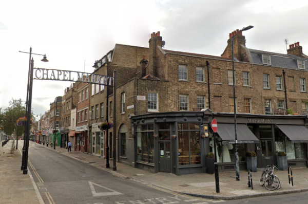
Chapel Market was built as a residential street in 1790 but gradually transformed into a market and shops (it still contains some original properties).
Other landmarks include St Silas Church, Pentonville, which opened in 1863 and still stands in Risinghill Street, and the Church of St Mark the Evangelist, which opened in Myddleton Square in 1855, and was demolished in 1970.
Initially a fashionable place to live, this led to the term ‘Pentonville’ being used to describe an area beyond its original boundaries (Charles Dickens was apparently guilty of doing this). But its reputation began to fade during the mid-19th century as some homes were converted into businesses and others became boarding houses and tenements. By the turn of the century it was one of London’s poorest districts.
The area was partly redeveloped with council housing during the period between the two world wars – this was continued to a greater degree after World War II.
Incorporated into the London Borough of Finsbury in 1899, Pentonville became part of the London Borough of Islington in 1965 (there was Pentonville ward in the borough until 1978).
Famous residents have included philospher and economist John Stuart Mill (born at 13 Rodney Street in 1806) and Vladimir Lenin, who lived with his wife at 30 Holford Square just off Pentonville Road briefly in 1902-03.
Pentonville Road, formerly part of New Road, shares the name and a number of other streets also feature related names including, of course, the aforementioned Penton Street. Interestingly, the (in)famous HM Prison Pentonville, is not located in the area but in Caledonian Road in Barnsbury, some distance to the north.
Of course, Pentonville (in the form of Pentonville Road) can also be found in the pale blue section of properties on the Monopoly board.
