A complex of three docks located on the Isle of Dogs, the West India Docks were founded more than 200 years ago and in recent decades have been redeveloped as the financial centre of Canary Wharf.
Canals
LondonLife – Quiet corner…
Lost London – ‘Canute’s Canal’…
A waterway said to have been cut by the Viking Canute (also spelled Cnut) in the 11th century, the canal, according to the story, was constructed so his fleet of ships – blocked by London Bridge – could get upstream.
The story goes that in May, 1016, the Dane Canute (and future King of England), led an army of invasion into England to reclaim the throne his father, Sweyn Forkbeard, had first won three years earlier.
Canute needed to get his ships upriver of London Bridge to besiege the city which was held by the Saxons under Edmund Ironside (made king in April after his father Athelred’s death) but was blocked by the fortified, although then wooden, London Bridge.
So Canute gave orders for the digging of a trench or canal across some part of Southwark so his ships could pass into the river to the west of the bridge and he could encircle the city.
The canal – also known as ‘Canute’s Trench’ – was duly dug and the city was besieged – although the Vikings lifted the siege without taking the city (which does seems like a lot of work for not much result in the end) and the war was eventually decided elsewhere.
Various routes of the canal have been posited as possibilities – including the suggestion that there was an entry at Rotherhithe (Greenland Dock has been sited as one location) and exit somewhere near Lambeth or further south at Vauxhall (and one possibility is that Canute, rather than digging a long canal, simply cut through the bank holding back the Thames on either side of London Bridge and flooded the lands behind).
Various waterways have also been identified with it including the River Neckinger, parts of which survive, and the now lost stream known as the Tigris.
Whether the canal actually existed – and what form it took – remains a matter of some debate (although the low-lying, marshy land of Southwark at the time surely would have helped with any such project). But whether lost or simply mythical, the truth of ‘Canute’s Canal’ remains something of a mystery. For the moment at least.
LondonLife – London’s tranquil top 10…
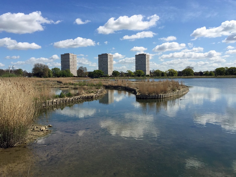
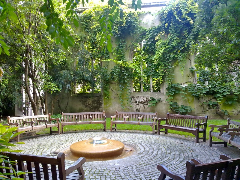
Woodlands, former churches and secluded city parks are all among the top 10 most tranquil places in London, according to the Tranquil City Index. According to a list published by the London Evening Standard, the top 10 puts Woodberry Wetlands in Stoke Newington (pictured above) at number one followed by the church ruins (now a park) of St Dunstan-in-the-East in the City of London (below), Cody Dock at Bow Creek and Beckenham Place Park. Postman’s Park in the City of London comes in at number five, followed by the Red Cross Garden in Southwark, Myatt’s Fields Park in Camberwell, Southmere Lake at Thamesmead, the Japanese Garden in Hammersmith Park (pictured) and, at number 10, the Paddington Arm of the Grand Union Canal. The index is the work of Tranquil City, an organisation which explores “our relationship with tranquillity in the urban environment to promote health, wellbeing and balance”. PICTURE: Top – diamond geezer (licensed under CC BY-NC-ND 2.0); Below – James Stringer (licensed under CC BY-SA 2.0).
LondonLife – Georgian ice house (re)discovered…
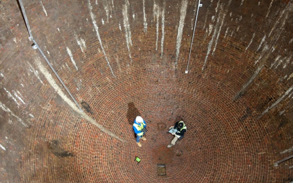
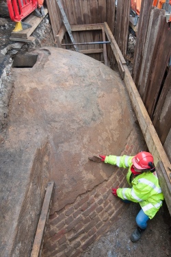 An 18th century ice house has been (re)discovered beneath the streets of Marylebone during a residential development project known as Regent’s Crescent. The subterranean red brick ice house – which measures 7.5 metres wide and 9.5 metres deep and was built in the 1780s – was used by pioneering ice-merchant William Leftwich during the 1820s to bring high quality ice to wealthy households and service the trend to serve frozen treats to guests as well as supply increasing demand from food retailers and medical institutions. Leftwich, seeing a niche for clean, quality ice (ice sourced from local canals and lakes during winter was often dirty), shipped ice collected in Norway’s frozen lakes and then transported it into London via Regent’s Canal. Now listed as a scheduled monument by Historic England, the egg-shaped ice house was rediscovered by MOLA archaeologists who were working on the site on behalf of property developer Great Marlborough Estates. It will now be incorporated into the gardens of Regent’s Crescent which have been newly designed by Kim Wilkie as part of the £500 million development project. The Grade I-listed crescent was originally designed by John Nash (of Buckingham Palace and Brighton Pavilion fame) and built in 1819. The houses were destroyed during the Blitz and replica properties were built in the 1960s. But the ice house, an entrance tunnel and ante-chamber all survived the bombing and remain in what MOLA has called “excellent condition”. It is anticipated that the ice house chamber will be open to public viewing via a special corridor during archaeological and architectural festivals.
PICTURES: Top – Buildings archaeologists from MOLA record the interior of the ice house/A MOLA archaeologist brushes the near perfect exterior of the ice house exposed during excavation in 2015 (Images© MOLA).
What’s in a name?…Little Venice
A nickname for a section of Paddington (or is it Maida Vale?) centred on the junction of Regent’s Canal and the Grand Union Canal (which links through to Paddington Basin), the origins of the term Little Venice are somewhat mysterious.
Some claim the area owes its moniker to the 19th century poet Robert Browning who moved back to London from Italy after his wife, Elizabeth Barrett Browning, died in 1861 and settled in the area until 1887 (before returning to Italy – Venice – where he died in 1889).
It was while living in the area that some say he apparently coined the name (his residence there, meanwhile, is also noted in the naming of Browning’s Pool, located at the junction of the two canals).
Others, however, give credit to another iconic 19th century literary figure – Lord Byron – but suggest the context wasn’t so much praise but rather a wishful statement noting that London could have had its own Venice if the canals weren’t so filthy.
Either way, the name apparently didn’t gain much currency until after World War II (and the ‘Little’ was apparently a late addition – the area was first simply known as London’s Venice).
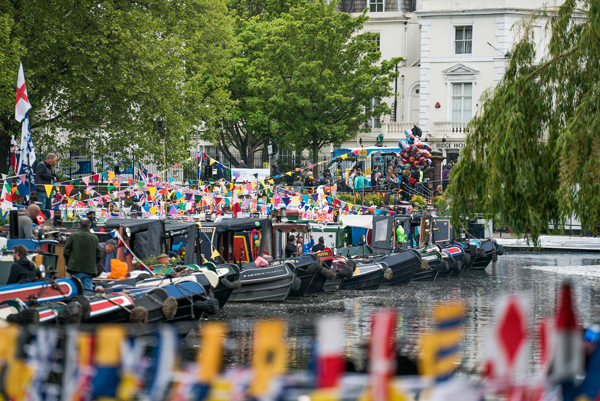
These days, Little Venice is a sought-after residential district and hosts some great cafes as well as pubs and theatres – including the Puppet Theatre Barge. It also serves as a terminus for various canal boat companies and hosts the annual IWA Canalway Cavalcade, which has been taking place since 1983 (pictured above).
As well as boasting its own island, Browning’s Pool, meanwhile, is also home to Rembrandt Gardens, named so in 1975 in honour of the 700th anniversary of the founding of Amsterdam.
Robert Browning aside, others who have lived in the area reportedly include artist Lucian Freud, singer Robbie Williams, entrepreneur Richard Branson and Michael Bond, creator of Paddington Bear.
PICTURE: Paul Hudson/CC BY 2.0
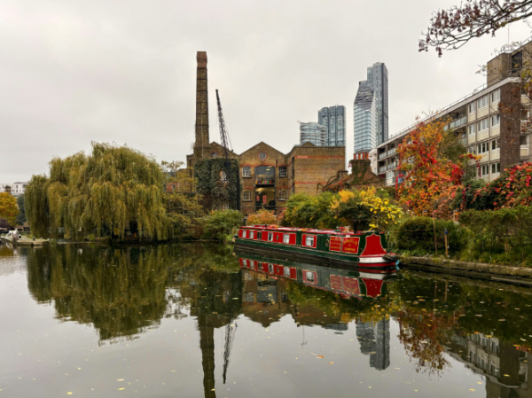
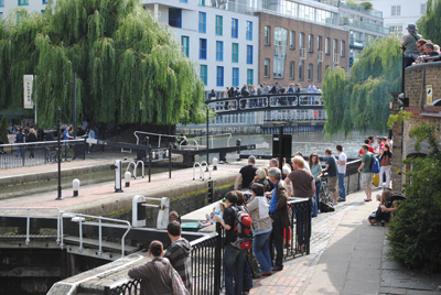
LondonLife – Quiet afternoon on the canal…

Regent’s Canal in the city’s north. For more on the history of the canal, see our much earlier post here.
What’s in a name?…Camden Town…
As with so many London locations, the name Camden Town comes from a previous landowner – but more indirectly it originates with the great 16th and 17th century antiquarian and topographer William Camden.
The story goes like this: late in his life William Camden – author of Britannia, a comprehensive description of Great Britain and Ireland – settled near Chislehurst in Kent on a property which became known as Camden Place.
In the 18th century, the property came into the possession of Sir Charles Pratt, a lawyer and politician (among other things, he was Lord Chancellor in the reign of King George III), who was eventually named 1st Earl of Camden.
It was Pratt who, having come into the possession of the property by marriage, in about 1791 divided up land he owned just to the north of London (which has apparently once been the property of St Paul’s Cathedral) and leased it, resulting in the development of what became Camden Town (Pratt, himself, meanwhile, is memorialised in the name of Pratt Street which runs between Camden High Street and Camden Street).
In 1816, the area received a boost when Regent’s Canal was built through it – the manually operated, twin Camden Lock is located in the heart of Camden Town.
Although it has long carried a reputation of one of the less salubrious of London’s residential neighbourhoods (a reputation which is changing), Camden Town is today a vibrant melting pot of cultures, thanks, in no small part, to the series of markets, including the Camden Lock Market, located there as well as its live music venues.
Past residents have included author Charles Dickens, artist (and Jack the Ripper candidate) Walter Sickert, a member of the so-called ‘Camden Town Group’ of artists, and, in more recent times, the late singer Amy Winehouse.
Of course, the name Camden – since 1965 – has also been that of the surrounding borough.
What’s in a name?…Maida Vale
This district in west London – located to the south-west of St Johns Wood – takes its name from the Italian town of Maida in Calabria where, in 1806, the British won a victory over Napoleon.
Led by Sir John Stuart (later Count of Maida), about 5,000 British troops defeated a larger number of French in a battle in what was a much-needed boost to the British after the defeat at Austerlitz in December the previous year.
 There was apparently a pub located in the area named, in the wake of the victory, ‘The Hero of Maida’ in reference to Stuart and his role in the battle. The pub has since gone but its name lives on in the street and the district which still carries it.
Landmarks in Maida Vale include the basin – complete with houseboats and the puppet theatre barge – known as Little Venice (some say this name was coined by poet Robert Browning; others attribute it to Lord Byron) where Regent’s Canal meets with the Paddington arm of the Grand Junction Canal (pictured is Regent’s Canal looking toward Little Venice).
Maida Vale is also home to the BBC Maida Vale Studios (on Delaware Road) while notable residents have included computer science pioneer Alan Turing who was born at 2 Warrington Crescent in 1912 and David Ben-Gurion, first Prime Minister of Israel, who lived at 75 Warrington Crescent.
The area to the south-west is unofficially known as Maida Hill and this was apparently initially the name used for the entire area until the more romantic Maida Vale came into usage in the mid 19th century. Maida Vale also gives its name to a Tube station – it opened in 1915.
Famous Londoners – John Nash…
Arguably the greatest architect of Regency London, John Nash’s imprint can still be seen in numerous sites around the city, from the master-planning of Regent’s Park and Regent Street to the beautiful buildings of All Soul’s Church in Langham Place and Marble Arch on the edge of Hyde Park.
Born the son of a Welsh millwright in Lambeth, London, on 18th January, 1752, Nash – who went on to work in a range of different architectural styles – trained as a draughtsman under the tutelage of architect Sir Robert Taylor and in 1777 established his own business as a builder and surveyor.
 But he certainly didn’t meet with immediate success and, following failure as a building speculator (he built properties in Bloomsbury Square and Great Russell Street but failed to make enough money from the venture – there’s a blue plaque on one of the houses, which he lived in, at 66 Great Russell Street), was declared bankrupt in 1783.
Meanwhile, his personal life was also in turmoil during these years – in 1775 he had married, Jane Kerr, the daughter of a Surrey surgeon, but separated from her in the early 1780s after various troubles including her eventually apparently having a child with a Welshman named Charles Charles, who is said to have died in prison after he was jailed for adultery.
Brought down by his misfortune, in the mid 1780s Nash moved to Carmarthen in Wales where he had family. Taking up work here, by the late 1780s he was designing prisons – the first was at Carmarthen – and worked on a number of other prominent buildings including St David’s Cathedral and various country houses.
Rising to prominence in Carmarthen society, by 1797, however, Nash was again working in London, initially in partnership with the renowned landscape architect Humphrey Repton with whom he had formed a business relationship some years earlier (although the partnership had soured over finances by 1800).
He built a substantial home at 29 Dover Street in Mayfair and in 1798, his first wife presumably dead, he married his second wife, Mary Anne Bradley, and soon started work on building a Gothic-inspired residence for them, known as East Cowes Castle, on the Isle of Wight. It was completed in 1802 but enlarged some years later.
Nash designed numerous country properties in the early 19th century, inspired by everything from castles to Italianate architecture, both in England and Ireland and soon came to the attention of the Prince Regent, the future King George IV (there was a rumour his wife was one of the prince’s discarded mistresses).
In 1806 he was officially made Deputy Surveyor General in the Office of Woods and Forests – the office which managed the Crown estate, and from 1815 on, he largely worked for the prince alone. Among the major London commissions from his royal patron were the design of Regent Street (he and his wife moved into number 14 in 1823) and the development of Regent’s Park on land formerly known as Marylebone Park and surrounding housing estates (for more on The Regent’s Park, see our earlier entry here). He also redeveloped St James’s Park.
In 1815, he was commissioned to develop the Prince Regent’s Marine Pavilion in Brighton and by 1822 had transformed the building into the spectacular Royal Pavilion which can be visited there today.
Nash was also involved in the development of The Regent’s Canal – which linked the Grand Union Canal in London’s west to the River Thames in London’s east and was completed in 1820 – and built many of the grand villas which still line it (for more on Regent’s Canal, see our earlier entry here).
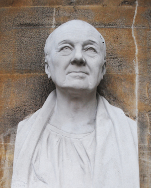
Becoming an official architect to the Office of Works in 1813 (an appointment which only ended in 1832, three years before his death), Nash went on to design churches – including All Soul’s in Langham Place (he’s depicted above in a bust at the church) – as well as West End theatres including the Haymarket Theatre and the Royal Opera House (which burnt down in 1867) as well as the adjacent Royal Opera Arcade and residences including Carlton House Terrace and Clarence House (for more on this, see our earlier entry here).
Other major commissions included the redevelopment of Buckingham Palace (parts of the current building are his work but the main facade isn’t – for more on the palace history, see our earlier entry here) and the Royal Mews, and the creation of Marble Arch, originally envisaged as the main gateway to the palace (see our earlier entry here). Nash also designed a conservatory for Kew Gardens.
Nash’s close relationship with the Prince Regent (who become King George IV on 29th January, 1820), meant that when the king died in 1830, he found himself on the outer (and his reputation took many years to recover thanks to his association with the unpopular king). With no knighthood forthcoming for his efforts (unlike many of his contemporaries) and the chance of further work unlikely (his work on Buckingham Palace had been left unfinished due to concerns over rising costs), Nash retired to his house on the Isle of Wight.
He died there on 13th May, 1835, and was buried in the churchyard at St James’s Church in East Cowes. He was survived by his wife who, having settled his debts, retired to Hampstead.
For an in-depth study of Nash, try Geoffrey Tyack’s book, John Nash: Architect of the Picturesque.
The Royal Parks – 8. Bushy Park
And so we come to the final entry in our special series on Royal Parks – Bushy Park (Royal Parks also look after Brompton Cemetery, but given it’s not strictly a park, we’ll deal with that in an upcoming post).
 Lying off the beaten track near Hampton Court in south-west London, Bushy Park’s location means it’s perhaps the least glamourous of the Royal Parks we have looked at. Yet, like the other parks, its connection with royalty goes back a long way – in this case to the time of King Henry VIII.
The park was included as part of the Hampton Court estate given to the king by Cardinal Wolsey. Henry immediately transformed what had been farmland (complete with artifical medieval rabbit warrens, the remains of which can still be seen) into a deer chase and enclosed the park with a brick wall (a section of the original wall lies on the north side of Hampton Court Road).
The character of the park was altered again in 1610 when King Charles I ordered the creation of the Longford River, a 12 mile ornamental canal designed to bring water from the River Colne in Hertfordshire to the park’s water features.
Christopher Wren had a hand in the park’s design in 1699 when he designed Chestnut Avenue – a mile long formal roadway which runs through the centre of the park. He also added the round pond at its end and placed a fountain topped with a statue in its midst.
Known as the Diana Fountain after the Roman goddess of hunting, the statue (pictured above with Chestnut Avenue behind) actually represents one of Diana’s nymphs Arethusa. It was commissioned by King Charles I for his wife, Queen Henrietta Maria, and originally stood at Somerset House before Oliver Cromwell moved it to the Privy Garden at Hampton Court and Wren then moved it to its current location.
The 17th and 18th century also saw the appearance of houses at the park to be used as hunting lodges (and the ranger’s home), and gardens were added.
Worth noting here is the story of shoemaker Timothy Bennet. A resident of nearby Hampton Wick, in 1752, when an old man, he successfully fought to ensure a public right-of-way through the park after the then ranger, Lord Halifax, ordered it closed to the public. There’s a monument to him outside Hampton Wick Gate and a walking path which runs across the park at perpendicular to Chestnut Avenue is still known as Cobbler’s Walk.
More gardens were added in the 20th century including the Waterhouse and Pheasantry Plantations. Other areas include the tranquil Woodland Gardens and the Water Gardens which are comprised of a Baroque-style collection of pools, cascades, basins and the canal. There are also a series of ponds – including a pond for model boats – to the east of Chestnut Avenue.
The park saw service in both World Wars. During the first, Canadian troops were stationed there (there’s a totem pole in the Woodland Garden marking this) and other areas within the park were used for growing produce as part of the “Dig for Victory” campaign.
During the second, it was used again for food production and in 1942 became a US base and later Supreme Headquarters Allied Expeditionary Forces – the location where General Dwight Eisenhower planned Operation Overland, the reinvasion of Europe which kicked off with the D-Day landings. There are memorials concerning this connection in the park’s north-east corner.
Facilities today include the Pheasantry Welcome Centre, which opened in 2009, and includes a cafe, toilets and information. There are also sporting facilities, a small cafe near the carpark and a children’s playground.
WHERE: The park lies north of Hampton Court Palace, just west of Kingston and Hampton Wick and south of Teddington (nearest train station is Hampton Wick or Hampton Court). WHEN: 24 hours except in September and November when it’s open between 8am and 10.30pm; COST: Free; WEBSITE: www.royalparks.gov.uk/Bushy-Park.aspx
Where’s London’s oldest…canal?
 London’s oldest canal is one that perhaps doesn’t immediately spring to mind when considering the city’s waterways – the Limehouse Cut in the city’s east.
Authorised by an Act of Parliament passed in 1766, the Cut was built in 1770 to link the River Lea (or Lee) – which it joins at Bromley-by-Bow – to the Thames at Limehouse.
It was designed to enable sailing barges coming down the Lee to avoid navigating the rather difficult curves in the lower reaches of the river at Bow Creek (and waiting for the tide to come in to the Thames so the barges could then go around the Isle of Dogs to the docks).
In 1968, the exit lock which led from the cut directly to the Thames was replaced by another short section of canal which linked it to what is now known as Limehouse Basin and was previously known as Regent’s Canal Dock.
The cut these days features an innovative floating towpath which leads under the A12, the northern approach road of the Blackwall Tunnel, and the old factory buildings which once lined it are giving way to modern apartment complexes and office blocks. Pictured is a section of the Limehouse Cut near the Limehouse Basin end.
10 small (and fascinating) museums in London…6. London Canal Museum
London’s Regent’s Canal no longer plays the important transport role it once did – it’s now largely for pleasure that people ply the waters from the East London Docks up to Little Venice. But its key contribution to the city’s development and those of other canals across the country are celebrated at this small museum.
 The museum, which sits just behind King’s Cross railway station, was opened in 1992 and features two floors of exhibits. They include half a narrow boat, the Coronis, which you can walk through to experience the cramped conditions in which the boatmen and their families once lived. There are also some fascinating recordings of people who actually did live on narrowboats about what life was like as well as displays and photographs of a lifestyle now long gone.
Outside, in Battlebridge Basin, is a moored a small collection of narrowboats while upstairs is a more detailed history of how the canals were developed, some fascinating film archival footage on a continuous loop, and a chance to operate a model of a lock.
As an added bonus, the museum is housed in what was once an ice warehouse and it’s still possible to view one of two massive ice wells which occupied the basement space where blocks of ice imported from Norway were once stored.
There are also displays on the history of the former ice business owner, Carlo Gatti, and some interesting information about the early days of ice and icecream in London – of particular note is the collection of ‘licking dishes’ in which icecream was sold for a penny.
WHERE: London Canal Museum, 12-14 New Wharf Road (nearest Tube station is King’s Cross); WHEN: 10am to 4.30pm, Tuesday to Sunday (open late until 7.30pm on the first Thursday of each month); COST: £4 an adult/£3 concessions/£2 children/£10 a family; WEBSITE: www.canalmuseum.org.uk
LondonLife – Waterbus on Regent’s Canal
 Regent’s Canal was fully opened in 1820 and linked the Grand Junction Canal, which ended at Little Venice in Paddington in London’s west, with the East London Docks and Limehouse in the east. Architect John Nash was one of the directors of the canal company and it was thanks to his friendship with the Prince Regent, the future King George IV, that the canal obtained its name. Nash saw the canal as an integral part of his plans for The Regent’s Park and it now runs along the park’s northern edge. Nash’s assistant James Morgan was the canal’s chief engineer. The waterbus service, which operates between Little Venice and Camden Loch, runs at various times daily until October. See here for timetable details.
What’s in a name?…King’s Cross
The location now known as King’s Cross, north-west of the City, takes its name from a monument adorned with an 11 foot high statue of King George IV which once stood on a site now occupied by King’s Cross Railway Station.
The area had been previously known as Broadford Bridge or Battlebridge – the latter a name many associated with the apparently erroneous belief that it was here, at a bridge which once crossed the River Fleet, the Iceni Queen Boudicca (also known as Boadicea) ill-fatedly confronted the Roman Army under the command of Gaius Suetonius Paulinus.
From the 1830’s (King George IV ruled from 1820 to 1830), however, the area took on the name of King’s Cross thanks to the erection of what Walter Thornbury described in his 1878 text, Old and New London, as a “ridiculus octagonal structure crowned by an absurd statue of George IV”.
The structure, said to be 60 feet high, was erected at the intersection of Gray’s Inn Road, Pentonville Road and what we now know as Euston Road, and during its relatively short lifespan, was employed at different times as a police station and as a pub (complete, apparently, with a camera obscura in the upper level).
It was completely removed by 1845 (King’s Cross Railway Station officially opened in 1852).
The area of King’s Cross has been settled back as far as Roman times – St Pancras Old Church is one of the oldest sites of Christian worship in England although the current church is Victorian – but it wasn’t until the 1700s and 1800s that it was transformed in to an urban area with the arrival of canals – including The Regent’s Canal – and the railways.
Traditionally one of London’s poorest areas, it survived World War II bombings but subsequently suffered as the railways declined in the post-war period. By the 1980s, it had become notorious as a red light district.
It has since gone through – and is still going through – a gradual gentrification process, however, with the 67 acre development King’s Cross Central among the projects currently under construction.
Key attractions of the area include The British Library, The London Canal Museum, arts centre King’s Place, and the recently refurbished St Pancras Renaissance London Hotel.
It’s also now home to St Pancras International – London’s Eurostar terminus (having been moved here from Waterloo) – as well as King’s Cross Railway Station which is believed by many, despite the lack of any evidence, to be the burial site of Queen Boadicea (it’s said she still lies beneath platform 9 or 10) and which is the home of the fictitious platform 9 and 3/4 from which Harry Potter catches the train to Hogwarts.
What’s in a name?…Fleet Street
Renowned around the world for its associations with journalism (not to be mention, it’s desirability as a Monopoly property), the origins of Fleet Street’s name go back to a river which still runs through London today.
 The River Fleet (the name Fleet is believed to come from a Saxon word, fleot, which means ‘flood’) these days actually runs under London, flowing from Hampstead Heath in the city’s north via sewers to spill into the Thames beneath Blackfriars Bridge.
A significant river in Roman times, by the medieval period the river had become polluted, thanks to the growth of industry along its banks. After the Great Fire of 1666, it was converted into the New Canal but this rather quickly fell out of use and sections of the river were covered for various urban projects from the 1730s onwards (the final sections, near the headwaters, were apparently covered in the 1870s).
Fleet Street, which takes its name from the river, has been known as such since medieval times and along its length, which runs east from where The Strand ends at Temple Bar to Ludgate Circus, is the location of a number of significant properties – from the Temple, formerly the property of the Knights Templar and now site of two Inns of Court, through to St Bride’s Church, St Dunstan-in-the-West and several old taverns, including Ye Olde Cheshire Cheese.
The street’s association with publishing goes back to the early 1500s when Wynkyn de Worde, apprentice to William Caxton, set up shop there and other printers and publishers followed. London’t first daily newspaper, The Daily Courant, was published there from 1702 and the street subsequently became home to many national newspapers (the press in the UK is still referred to as ‘Fleet Street’ although these days no newspapers are based there – the last media outlet, Reuters, moved out in 2005).
There have recently been suggestions that the river Fleet could once again be uncovered as part of a bid to revitalise London’s “lost” waterways.
