Located in the heart of Leicester Square, this fountain is topped with a statue of William Shakespeare.
Victorian
Famous Londoners -Thomas Cubitt…
A master builder and architect responsible for the development of key historic streets and squares in inner London during the first half of the 19th century, Thomas Cubitt’s legacy can still be seen in many places around London today.
Born in Buxton, near Norwich in Norfolk, on 25th February, 1788, Cubitt was the son of carpenter Jonathan Cubitt and his wife Agnes.
He took up his father’s trade at an early age and, drawing on those skills, journeyed to India as a ship’s carpenter, earning enough that he could start his own building firm around 1810. Joined by his brother William, they established themselves on Gray’s Inn Road in Holborn.
Their first major job was the construction of the London Institution in Finsbury Circus in 1815 and they went on to work on speculative housing projects in Camden Town and in Highbury Park in Stoke Newington.
Cubitt’s approach to such housing developments was somewhat revolutionary – he was one of the first builders to employ people of various trades, meaning he could offer those who sought his services something of a one-stop shop.
It was around this time – 25th March, 1821 – that he married Mary Anne Warner at St Marylebone Church. They would go on to have at least 12 children (and his descendants reportedly include Queen Camilla – he’s her great-great-great grandfather).
Cubitt’s major works in the development of London came in the 1820s when he was commissioned to build housing on the Duke of Bedford’s estate in Bloomsbury and by Richard Grosvenor, later 2nd Marquess of Westminster, to build homes in Belgravia, centred on Belgrave and Eaton Squares.
He also built housing to the south of Belgravia in an area which become known as Pimlico, nicknamed “Mr Cubitt’s District”, and as part of that development built several hundred yards of the Thames Embankment.
Said to be called the “Emperor of the Building Trade” by some, Cubitt also undertook development in Clapham Park and was responsible for a large part of Kemp Town in Brighton.
In 1827, the partnership between Thomas and his brother William (which also included younger brother Lewis, an engineer) was dissolved. William, later a Lord Mayor of London, took over management of the Gray’s Inn Road business, while Thomas focused his attentions on other projects (Lewis, meanwhile, would late rejoin William in the business).
Thomas’ subsequent projects included working with Prince Albert on the design and construction of Osborn House on the Isle of Wight, and, between 1847-50, building extensions to Buckingham Palace (as part of that work, he was responsible for moving the Marble Arch from the palace to Hyde Park). Cubitt was also one of those behind plans to turn Battersea’s water-logged fields into a public park.
Later in life, Cubitt bought and built a mansion for himself, Denbies House near Dorking. It was there that he died on 20th December, 1855. He was buried at the West Norwood Cemetery in south London. He was survived by his wife, seven of his children and both William and Lewis. Queen Victoria was among those who paid tribute to his life and career.
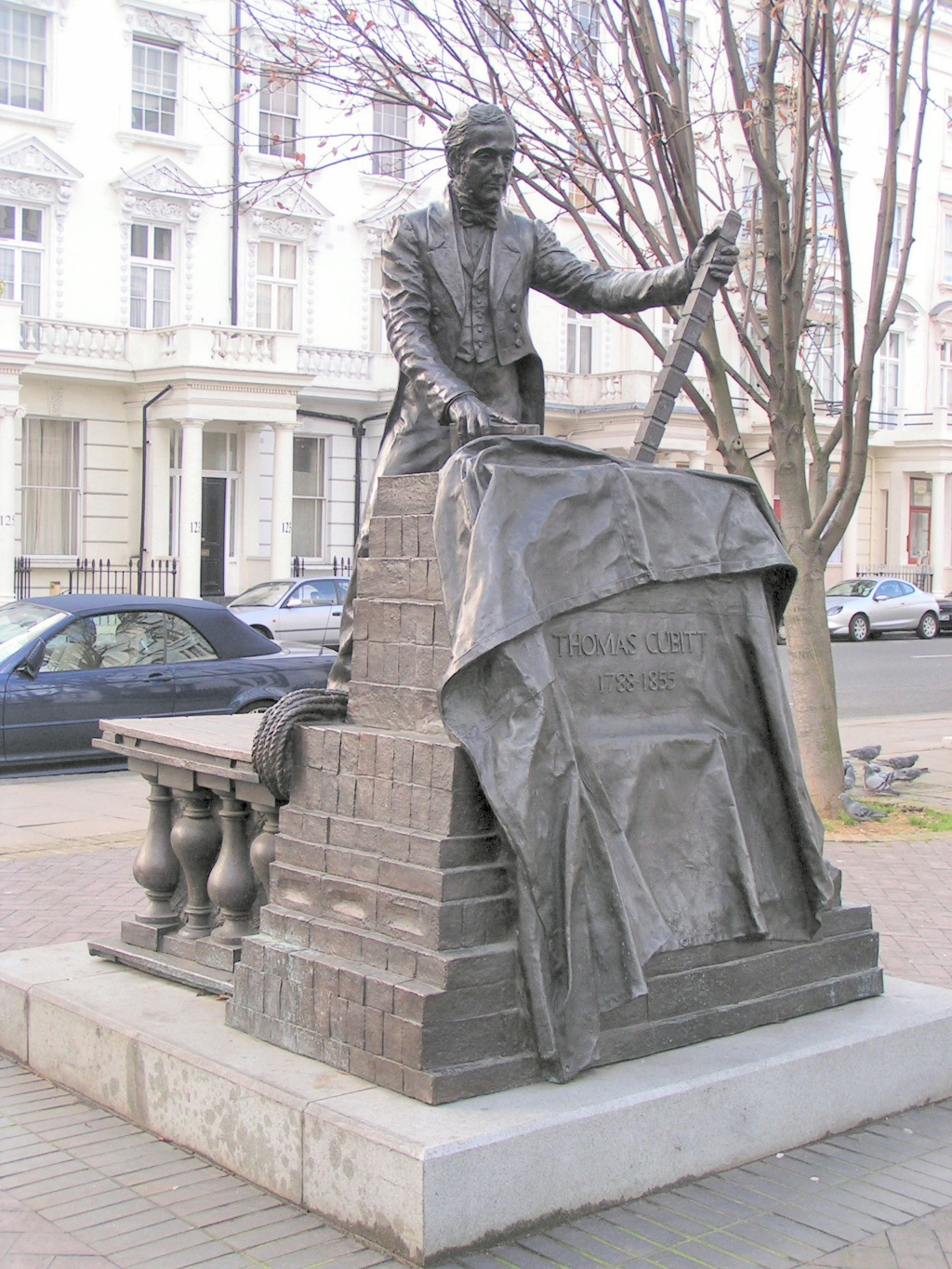
A statue of him (pictured) in Denbigh Street, London – near some of his former workshops – was unveiled by Gerald Grosvenor, 6th Duke of Westminster, in 1995. It is the work of William Fawke and donated by the Sanctuary Housing Association. There is a second statue of him in Dorking.
An English Heritage Blue Plaque marks the site of his former workshop at 3 Lyall Street – known as Cubitt Lodge, the building was built by him in 1847 and remained his headquarters and workshop until his death.
London Pub Signs – The Three Greyhounds…


This Soho institution, located in a mock Tudor building in Greek Street, has something of a storied music history.
The pub’s name is apparently related to the dogs that were in years’ past used in the area for hunting hares.
There’s been a pub here since at least 1847 and its location in an area redolent with music history has led to an interesting clientele. They are said to have included members of punk groups The Sex Pistols, who resided nearby Denmark Street, and The Clash.
It’s also suggested the pub was the “drinking haunt” of Wolfgang Amadeus Mozart although it seems his time in London predates the current building by decades (and he was only a child when in London).
The pub also featured in the film Bend It Like Beckham.
The pub, now part of the Nicholson chain, can be found at 25 Greek Street. For more, see https://www.nicholsonspubs.co.uk/restaurants/london/thethreegreyhoundssoholondon#/.
What’s in a name?…Stockwell…
This district in the Borough of Lambeth in south London was formerly a rural manor located on the southern edge of London.
The name, variants of which date back to at least the late 12th century, is said to relate to the Old English words for a tree trunk – ‘stoc’ – and a well or spring, ‘wella’, and has been interpreted as meaning the well or spring by a tree stump, tree truck or perhaps a wood (there was apparently a Stockwell Wood which has long since disappeared).
The manor of Stockwell was formed at the end of the 13th century when King Edward I acquired the manor of South Lambeth and divided it into two, creating the manors of Stockwell and Vauxhall (the manor house itself, parts of which survived until the 19th century, stood on the north side of Stockwell Road).
The area become known for its market gardens and was transformed into an urban landscape until the mid-19th century. Remnants of the 19th century housing stock can still be found in areas including the Stockwell Park Conservation Area in the west of the district.
The area around Stockwell Tube station, which first opened in 1890 and has since been rebuilt a couple times, was heavily bombed during World War II and rebuilt following the war. New developments included a number of social housing estates.
Today, Stockwell and nearby South Lambeth host the district known as Little Portugal which, centred on South Lambeth Road, is home to one of the UK’s largest Portuguese communities. The area is also home to several other immigrant communities.
Local landmarks include the oldest surviving building in the area – St Andrew’s Church, Stockwell Green (built in 1767), the Stockwell Congregational Church (1798) and the Stockwell War Memorial.
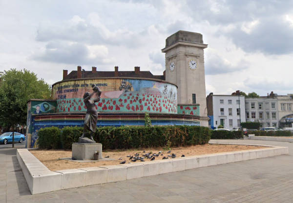
The latter – a white stone tower – is located on a site first laid out in the 1920s and features a mural on an adjoining ventilation shelter commemorating French Resistance fighter Violette Szabo (there’s a Blue Plaque on her former home in Burnley Road) and other Stockwell residents who died in war. There is also the ‘Bronze Woman’ statue which was unveiled in 2008 as a tribute to Black Caribbean women.
Residents of Stockwell have included artist Arthur Rackham and pioneering theatre director Joan Littlewood as well as musician David Bowie (born in Stansfield Road), actors Joanna Lumley (who still lives there) and Roger Moore (born in Aldebert Terrace).
Tragically, Stockwell Tube station was where Brazilian man Jean Charles de Menezes was fatally shot by police on 22nd July, 2005, after being misidentified as one of four suicide bombers who were on the run after their devices had failed to detonate the previous day (the attempts had come just two weeks after the 7th July bombings in which more than 50 people had been killed).
Treasures of London – Coronation Stone, Kingston upon Thames…
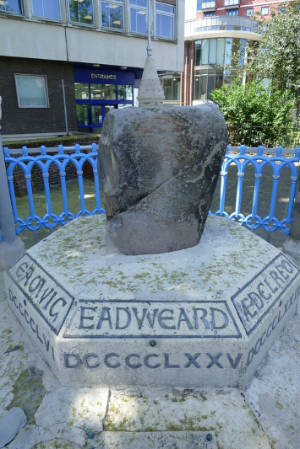
This month marks the 1,100th anniversary of the coronation of the Saxon King Aethelstan, so we thought it fitting to recall the place of his coronation, believed to be the Coronation Stone at the heart of the south-west London Royal Borough of Kingston upon Thames.
Located outside the Guildhall, the now Grade I-listed stone is an ancient block of sarsen stone which was originally at a chapel, believed to have been wooden, on the edge of the town’s market place (close to the site of All Saints Church which originally dates from the 12th century).
Subscribe to access all of Exploring London’s content for just £3 a month.
Lost London – Kew Gardens’ flagpole(s)…
Once the tallest wooden flagpole in the world at 68 (225 feet) tall, the Kew Gardens flagpole stood for almost 50 years before it was dismantled in 2007.
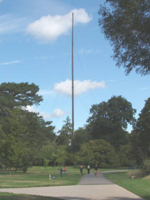
The flagpole, a Douglas fir from Copper Canyon on Vancouver Island, was erected on 5th November, 1959, as a gift from the the British Columbia Loggers Association in Canada to mark both the centenary of the Canadian province of British Columbia (1958) and the bicentenary of Kew Gardens (1959).
The tree, which was around 370-years-old when cut, had originally weighed 37 tonnes, but after it was floated up the Thames to Kew and there underwent shaping, this was reduced to 15 tonnes.
Sadly, in 2006, it unfortunately failed its safety inspection – thanks to decay and woodpeckers – and was taken down the following year.
The flagpole was apparently the third (strictly the fourth) erected on the same site at the gardens which had originally been occupied by the ‘Temple of Victory’, a structure which had been built on the orders of King George III to commemorate the Anglo-German victory over the French at the 1759 Battle of Minden during the Seven Years’ War and which was removed in the mid 19th century.
The first flagpole on the site, which stood more than 31 metres (100 feet) tall. was erected in 1861. It had also come from Vancouver Island in British Columbia and replaced one which had snapped when it was in the process of being erected.
The pole was finally taken down in 1913 after being found to be suffering from dry rot.
A replacement, again from British Columbia, was erected in 1919 (its raising having been somewhat delayed by factors related to World War I). It was removed some time before 1959.
After the third giant flagpole was removed (the concrete footing can still be seen), the gardens decided not to erect another as that would mean cutting down another large tree. While far less of a spectacle, there is now a lesser flagpole near Victoria Gate where the flag is flown on special occasions.
10 historic London docks…7. Royal Docks…
This series of three inter-connected docks in London’s east were once the largest enclosed docks in the world (they’re still the largest enclosed docks in the UK).
Subcribe for just £3 a month to access all of Exploring London’s content…
LondonLife – Cambridge completes a clean sweep at The Boat Race…
CCambridge took the honours over Oxford in both the men’s and women’s races as well as both reserve races and the lightweight men’s and women’s races in the annual rowing event on the River Thames in west London on Sunday.

The Light-Blues won the men’s race by five-and-a-half lengths – their sixth victory in seven years, while the women won by two-and-a-half lengths in their eighth consecutive win.

There was controversy when the women’s race had to be restarted – the first time its happened on the Championship Course (the women’s race moved there in 2015 having earlier been held at Henley-on-Thames and before 1977 on the River Isis in Oxford and the Cam in Cambridge – and history was also made in the men’s race with Sarah Winckless the first female umpire.

The first men’s race was held in 1829 and the first women’s in 1927. It takes place over what is known as the Championship Course which covers 4.25 miles between Putney and Mortlake.
For more on the race, see www.theboatrace.org.
10 historic London docks…5. The London Docks…
Once the largest enclosed docks in the world, the London Docks were constructed in Wapping in the early 19th century.
Subscribe for just £3 a month to access all of Exploring London’s content.
London pub signs – The Mudlark…
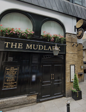
This pub, located in Southwark, just north of Borough Market (and Southwark Cathedral), owes its name to the proximity of the river and the traditional practice of mudlarking – a word used to describe the idea of scavanging the banks of the Thames for valuables.
Mudlarking rose to prominence in the 18th and 19th centuries and the mudlarks were often children, mostly boys, who would undertake the dangerous activity of scavanging the foreshore of the tidal Thames on a daily basis in an effort to supplement the family income.
The 19th century journalist Henry Mayhew wrote about mudlarks he encountered on the river, including a nine-year-old who, dressed in nothing but trousers that had been worn away to shorts, had apparently already been about the activity for three years.
The mudlarks were after anything that could be sold for a small income – coal, ropes, bones, iron and copper nails.
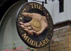
The practice continues today – and has unearthed some fascinating historic finds – but anyone wanting to do so needs a permit from the Port of London Authority (and must respect rules around their finds that are of an historical nature).
The pub, meanwhile, originally dates from the mid-1700s and used to feature child mudlarks on its sign (it now has a hand holding a mudlark’s find of a coin).
It is (unsurprisingly, given the location) said to be popular with market traders and attendees.
The pub, located on Montague Close, is these days part of the Nicholson’s chain. For more, see https://www.nicholsonspubs.co.uk/restaurants/london/themudlarklondonbridge#/
10 historic London docks…2. St Katharine Docks…
Located just to the east of the Tower of London, St Katharine Docks were opened in 1828 following the demolition of more than 1,000 houses along with a brewery and what was left of the medieval St Katharine’s Hospital.
Subscribe for just £3 a month to access all our content!
This Week in London – The Charles Dickens Museum celebrates 100 years; activist Olive Morris commemorated; and, ‘The Story of Soldier Magazine’…
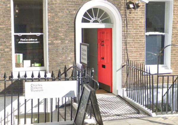
• The Charles Dickens Museum, located in the author’s former home at 48 Doughty Street in Bloomsbury, is marking its centenary this year, and to celebrate the occasion, it’s holding a special exhibition of highlights from its collection. The museum, which first opened its doors on 9th June, 1925, has brought together everything from Dickens’ hairbrush, walking stick and only surviving suit through to portraits and photographs made during his lifetime as well as original manuscripts, letters to his family and friends and rare first editions. The exhibition runs on 29th June. Admission charge applies. For more, see https://dickensmuseum.com/.
• Housing rights campaigner and activist Olive Morris has been commemorated with an English Heritage Blue Plaque in Brixton. Jamaican-born Morris (1952-1979), who dedicated her life to helping the oppressed and exploited, hosted Black women’s study groups and lived as a squatter at the three storey property at 121 Ralston Road in the 1970s. She was a significant figure in the British Black Panther movement, co-founded the Brixton Black Women’s Group and the Organization of Women of African and Asian Descent in 1978, and was one of the “Old Bailey three” who were acquitted after being prosecuted over a protest outside the Old Bailey, winning the right to a fair representation of Black people on the jury during the court proceedings. For more, see www.english-heritage.org.uk/visit/blue-plaques/.
• Soldier magazine, the official magazine of the British Army, is marking its 80th anniversary with an exhibition ay the National Army Museum. The Story of Soldier Magazine charts the publication’s history from March, 1945, when it was launched by Field Marshal Bernard Law Montgomery, through the role it’s played in covering every major conflict since as well as the issues shaping military life. Runs until 6th July. Admission is free. For more, see https://www.nam.ac.uk.
Send all items for inclusion to exploringlondon@gmail.com.
What’s in a name?…Archway…
This north London district in the London Borough of Islington owes its name to a bridge which straddles Archway Road (part of the Great North Road or A1).
The bridge’s origins go back to the early 19th century when work began on a 230 metre-long tunnel underneath Highgate Hill which would allow users to bypass the hill’s steep gradient. If completed, it’s said it would have been the earliest road tunnel in Britain.
But in April, 1812, the tunnel collapsed and a cutting through the hill, utilising the work done on the collapsed tunnel, was then proposed. It would become Archway Road.
Hornsey Lane, however, ran across the top of the hill linking Highgate to its west to Crouch End in the east, and to ensure the lane remained when the cutting was completed, it was decided to build a viaduct to carry the lane across the cutting.
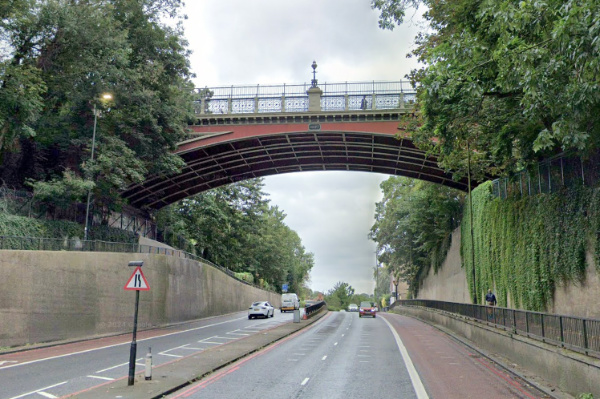
The resultant structure was designed by none other than John Nash in the style of a Roman aqueduct and opened in 1813.
Archway Road, which ran underneath the arch, was operated as a toll road until 1871.
The bridge, meanwhile, was demolished in 1900 and replaced by a cast iron bridge, designed by Alexander Binnie, which still stands.
The area was referred to as Highgate Archway but gradually the Highgate was dropped and plain Archway adopted.
This was reinforced by the naming of the Tube station in Junction Road which was originally named Highgate when it opened in 1907 as the terminus of the Northern Line but was renamed Archway (Highgate) in 1939 and then just Archway in 1947.
Landmarks in this predominantly leafy residential area include the Whittington Hospital, originally built as the Holborn Union Infirmary 1877-79, on Highgate Hill.
On a similar theme, the Whittington Stone can also be found at the bottom end of Highgate Hill. It is said to commemorate the spot where Dick Whittington, having decided to leave London after failing to make his fortune, heard the Bow Bells ringing and turned back (the stone is topped with a statue of Whittington’s famous cat).
The green expanse of Hampstead Heath lies just to the west.
LondonLife – London, 1879…
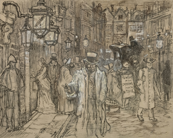
10 towers with a history in London – 9. The Queen’s Tower, Imperial College London…
This free-standing, 287 foot-high tower is a survivor – it’s all that remains of the Imperial Institute.
Subscribe for just £3 a month to get access to all Exploring London’s stories – that’s less than the cost of a cup of coffee!
London Explained – Albertopolis…

A nickname, connected to Prince Albert (beloved husband of Queen Victoria), which was given to an area of South Kensington centred on Exhibition Road which is packed with various cultural and educational institutions.
The land, which had been the Kensington Gore Estate, was purchased by the Royal Commission for the Exhibition of 1851 on the suggestion of Prince Albert using the profits made from the Great Exhibition which had been held just to the north in Hyde Park. His vision was for arts and science quarter which included schools, colleges and libraries as well as museums, exhibition rooms and spaces for events.
Among the buildings subsequently constructed upon it were those bearing Prince Albert’s name including Royal Albert Hall and the Victoria and Albert Museum along with the huge Albert Memorial.
Other institutions on the land include the Natural History Museum, Imperial College London, the Royal College of Music, the Royal College of Art, the Science Museum, the Royal Geographical Society and the since removed Royal Horticultural Society Gardens.
The area gained its nickname in the 1850s due to the Prince’s role in the Great Exhibition and its subsequent purchase and was seen to both celebrate, but also by some, to satirise him. It fell out of use after the Prince’s death in 1861 but was subsequently revived in the 1960s and since to bring attention to buildings in the area threatened with demolition.
A pedestrian subway under Exhibition Road runs north from South Kensington Station and gives access to the museums (when it was built in 1885, a toll of one penny was charged to use it).
10 towers with a history in London – 4. Caledonian Park Clock Tower…
Located in Islington, the Caledonian Park Clock Tower is a local landmark and among all that now remains of the 19th century Metropolitan Cattle Market.
Subscribe for just £3 a month – less than the cost of a coffee – to get access to all of Exploring London’s content!
10 towers with a history in London – 2. The tower of St Olave, Old Jewry…
This tower is a survivor and was originally part of the rebuilt Church of St Olave, Old Jewry.
The medieval church, which was apparently built on the site of an earlier Saxon church, originally dated from 12th century. Its name referred to both the saint to whom it was dedicated – the patron saint of Norway, St Olaf (Olave) – and its location in the precinct of the City that was largely occupied by Jews (up until the infamous expulsion of 1290).
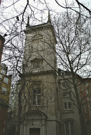
The church, which is also referred to as Upwell Old Jewry (this may have related to a well in the churchyard), was the burial place of two former Lord Mayors – mercer Robert Large (William Caxton was his apprentice) and publisher John Boydell (who apparently washed his face under the church pump each morning). Boydell’s monument was later transferred to St Margaret Lothbury.
The church was sadly destroyed in the Great Fire of 1666 but it was among those rebuilt under the eye of Sir Christopher Wren in the 1670s. It’s from this rebuilding that the current tower dates.
At this time, the parish was united with that of St Martin Pomeroy (which had already shared its churchyard and which was also destroyed in the Great Fire).
Wren’s church was eventually demolished in 1887 as moves took place to consolidate church parishes under the Union of Benefices Act – the parish was united with that of St Margaret Lothbury and proceeds from the sale were used to fund the building of St Olave, Monor House. It’s worth noting that a Roman pavement was found on the site after the church demolition.
The tower (and the west wall), meanwhile, survived. The tower was subsequently turned into a rectory for St Margaret Lothbury and later into offices.
Interestingly, the Grade I-listed, Portland stone tower is said to be the only one built by Wren’s office which is battered – that is, wider at the bottom than the top. It’s topped by some obelisk-shaped pinnacles and a weather vane in the shape of a sailing ship which was taken from St Mildred, Poultry (was demolished in 1872).
The tower’s former clock was built by Moore & Son of Clerkenwell. It was removed at the time of the church demolition was installed in the tower of St Olave’s Hart Street. The current clock was installed in 1972.
Lost London – The Guildhall Chapel…
Used by the Lord Mayor of London and his retinue as a location for weekly worship for more than 200 years, the Guildhall Chapel was once an important part of the City infrastructure.
Please consider supporting our work for just £3 a month.
Treasures of London – The Griffin Tazza…
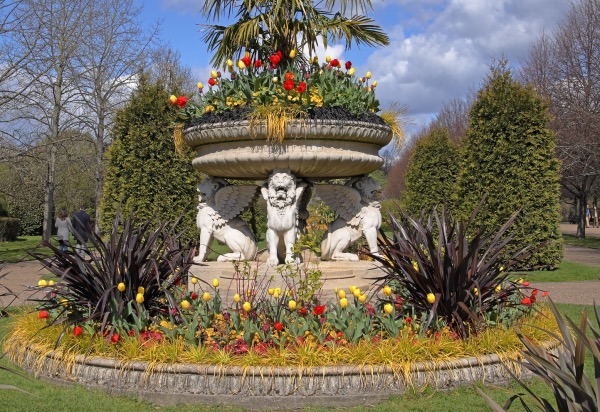
Located in The Regent’s Park, this circular stone planter – often called the ‘Lion Vase’ – dates from the 1860s.
The vase (‘tazza’ just means ‘vase’), which features a circular bowl sitting atop four winged lions or griffins, was designed by Austin and Seeley out of artificial stone.
It was installed as the centrepiece of the Italian Gardens by their designer, William Andrews Nesfield, in 1863.
The vase – which is one of about 30 stone vases in the Avenue Gardens – was restored in the mid-1990s.
WHERE: The Griffin Tazza, The Avenue Gardens, The Regent’s Park (nearest Tube stations are Regent’s Park and Great Portland Street); WHEN: 5am to 9:30pm daily; COST: Free: WEBSITE: www.royalparks.org.uk/visit/parks/regents-park-primrose-hill

