London hills
10 London hills – 7. Brockley Hill…
Located in Stanmore in London’s northern outskirts, Brockley Hill has an elevation of 136 metres above sea level.
The name apparently comes from an Old English word for badger holes (the sandy soil on top of the hill being easier for them to dig than the surrounding clay).
The Celtic tribe the Catuvellauni is believed to have had a settlement on the hill top and legend says that it was on the hill that a battle was fought between the Catuvellauni, under their leader Cassivellanus, and the Roman Julius Caesar in 54 BC.
The Romans later are understood to have established their own settlement on the hill – Sulloniacae – which was served as an imperial posting station on Watling Street as it made its way north from Marble Arch to Verulamium (St Albans).
The sandy soil also meant the area was a centre for pottery making during the Roman period, in particular flagons and vessels known as mortaria (bricks were made here in more recent centuries). There’s a plaque commemorating the Roman pottery on the A5 (just pass the junction with Wood Lane)
There is an obelisk commemorating the battle on top of the hill which was erected in 1750 (which can still be seen although it suggests the Catuvellauni won the battle when historians today believe the reverse). It stands now in the grounds of the Royal National Orthopaedic Hospital which moved into the site of an earlier hospital in the late 1920s.
10 London hills – 6. Shooter’s Hill…

The highest point in the Borough of Greenwich in London’s south-east, Shooter’s Hill rises to 433 feet (132 metres) above sea level and provides views over the Thames to the north and London to the west as well as Kent and Essex.
The name, which is also that of the surrounding district, apparently comes from the fact that archery was practiced there in the Middle Ages.
But the area – which still is reasonably well wooded – was also the haunt of highwaymen (in response, there was a gallows at the crossroads at the bottom of the hill and a gibbet on the summit where bodies were displayed).
The modern road known as Shooters Hill Road, part of the A2 and later the A207, follows part of the route of the ancient roadway known as Watling Street.
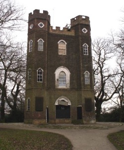
Landmarks on the hill include a Gothic revival water tower dating from 1910 and a rather impressive folly known as Severndroog Castle which was built in in 1784 by Lady James in honour of her husband, Commodore Sir William James, who captured a pirate fortress at Suvarnadurg on India’s west coast in 1755.
Other landmarks include Christ Church Shooters Hill which features a Grade II-listed milestone and a Bronze Age mound known as Shrewsbury Barrow.
Literary mentions include one in Samuel Pepys’ famous diary – he rode past a body on the gibbet in 1661 – and in Charles Dickens’ A Tale of Two Cities.
10 London hills – 1. Ludgate Hill…
Rome has its seven hills, Athens has the Acropolis and Paris – well, who can go past Montmatre? Yet, while hills may not be the first thing which come to mind when thinking of London, the city is home to numerous (low) peaks which have shaped the urban environment since ancient times (and some of which provide magnificent viewing points).
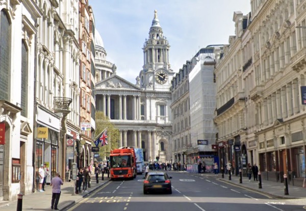
First up, we’re looking at Ludgate Hill, located in the western end of the City of London. One of the three ancient hills within the City walls, Ludgate Hill, which is now the site of St Paul’s Cathedral, is believed in Roman times to have been the site of a temple dedicated to Diana.
The hill, which today rises just 17.6 metres above sea level (the highest point lying apparently just to the north of the cathedral), is named after the former city gateway of Ludgate which is, in turn, named after the mythical King Lud.
These days the hill’s name is also commemorated in a street – Ludgate Hill – which runs from Ludgate Circus at its western end to St Paul’s Churchyard at its eastern end. It was also formerly the name of a railway station which opened in the late 1860s but was closed in 1923.
