There are a number of “city farms” in London and one of the largest is Mudchute Park and Farm on the Isle of Dogs.
Isle of Dogs
10 historic London docks…9. Millwall Dock…
Located on the southern end of the Isle of Dogs, Millwall Dock opened in March, 1868.
Subscribe for just £3 a month to see all of Exploring London’s content…
10 historic London docks…4. West India Docks…
A complex of three docks located on the Isle of Dogs, the West India Docks were founded more than 200 years ago and in recent decades have been redeveloped as the financial centre of Canary Wharf.
Subscribe to see all our content for just £3 a month!
LondonLife – Mudchute Park & Farm, Isle of Dogs…
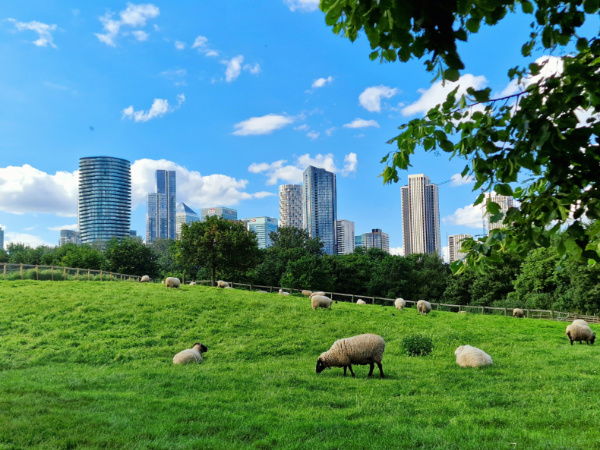
Established in the 1970s, Mudchute Farm and Park – at 32 acres – is one of the largest urban farms in Europe and is home to more than 100 animals including, as well as these sheep, pigs, goats, cows, ducks, geese, chickens, rabbits, and llamas. For more, see www.mudchute.org.
10 subterranean sites in London – 1. The Greenwich Foot Tunnel…

An institution linking the Isle of Dogs to Greenwich underneath the Thames for more than a century, the Greenwich Foot Tunnel was built to provide an alternative to a sometimes unreliable ferry service – thanks to weather – and was principally aimed at workers making their way from their homes in London’s south to docks and shipyards.
It was one of two tunnel crossings – the other being at Woolwich – which were lobbied for by Will Crooks, chair of the LCC’s bridges committee and later MP for Woolwich.
Designed by engineer Sir Alexander Binnie for the London County Council, the project – which reportedly cost some £127,000 – commenced in June, 1899, with the tunnel completed and opened, with very little fanfare (there was apparently no opening ceremony) on 4th August, 1902.
The design features a glass-topped dome at either end with steps spiralling downward (reported as 87 steps to the north and 100 to the south). Lifts were installed in 1904 and then upgraded in the 1990s and more recently in 2012. The tunnel itself. which is positioned at a depth of about 50 feet, is made of cast-iron and lined with 200,000 glazed white tiles. It measures 1,215 feet long with an internal diameter of nine feet.
The northern end of the tunnel was damaged by bombs during World War II and repairs include a thick steel and concrete lining that substantially reduce the interior size of the tunnel for a short distance.
The tunnel, which has its own friends group, is classed as a public highway and so as a matter of law is kept open 24 hours a day. Its depth means it remains a cool place even on a hot day.
WHERE: Greenwich Foot Tunnel (nearest DLR (northern end) is Island Gardens and (southern end) is Cutty Sark; WHEN: Always; COST: free; WEBSITE: www.royalgreenwich.gov.uk/info/200102/walking/693/foot_tunnels.
PICTURES: Top – James Stringer under licence CC BY-NC 2.0; and below – Neil Turner under licence CC BY-SA 2.0

10 of the most memorable (and historic) views of London – 10. View of Maritime Greenwich…
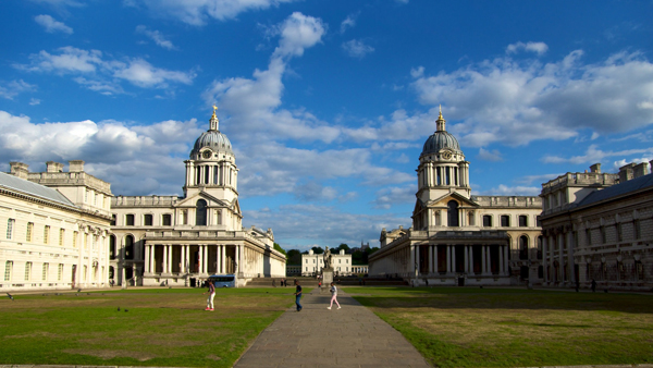 For the final in our series of memorable (and historic) views of London, we’re returning to Greenwich, except this time we’re looking across the River Thames from the southern end of the Isle of Dogs at some of the historic buildings of maritime Greenwich.
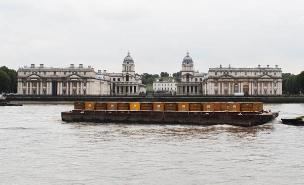
The splendid view from Island Gardens on the north bank of the Thames today reveals Sir Christopher Wren’s Old Royal Naval College, the Queen’s House and beyond that the Royal Observatory in Greenwich Park. But it wasn’t always so.
Prior to its demolition by King Charles II in 1660, this was the site of a royal palace known Greenwich Palace or the Palace of Placentia which had occupied the site since the mid-15th century (and was rebuilt by King Henry VII in the late 15th/early 16th centuries).
Charles decided to demolish it to build a new palace on the site but only a section of it was ever completed and it was never used as a royal palace. In the late 17th century, Greenwich Hospital – incorporating what was built of Charles’ palace – was constructed on the site as a home for retired sailors from the Royal Navy. From 1869, it was used as the Royal Naval College and now houses a range of organisations (see our previous post here for more).
The Queen’s House, which lies at the centre of the view, was designed by Inigo Jones and started on the orders of Anne of Denmark, wife of King James I. But it remained unfinished when Queen Anne died in 1614 and it was Henrietta Maria, wife of King Charles I, who completed it. The house these days serves as a gallery (for more, see our earlier post here).
Behind the Queen’s House can be seen the Royal Observatory, home of Greenwich Mean Time and the Prime Meridian (see our previous post here) – as well as, of course, the (previously aforementioned) statue of General Wolfe. Also in the modern view from Island Gardens is the Cutty Sark and the National Maritime Museum.
It’s believed that the view from where Island Gardens now stands is that replicated in Canaletto’s painting, Greenwich Hospital from the North Bank of the Thames (although, oddly, whether Canaletto ever actually visited the site is apparently a matter of some dispute).
Greenwich Park and the buildings on the other side of the river can be accessed from the park Island Gardens by the Greenwich Foot Tunnel.
WHERE: Island Gardens on the north bank of the River Thames (nearest DLR is Island Gardens); WHEN: Anytime; COST: Free; WEBSITE: (For Greenwich Park across the river – www.royalparks.gov.uk/Greenwich-Park.aspx).
PICTURE:Top – Paul Hudson/Flickr/CC BY 2.0; Below – David Adams
10 notable blue plaques of London – 7. A blue plaque for a ship…
As mentioned last week, there are a number of official English Heritage blue plaques in London which commemorate events rather than people.
Alongside the blue plaque commemorating the first V1 flying bomb to hit London (the subject of last week’s entry) is a blue plaque commemorating the site where one of world’s most famous ships – the SS Great Eastern – was built.
 The plaque is located at Burrells Wharf, 262 Westferry Road, on the Isle of Dogs in the Docklands, and it was there that the design of Isambard Kingdom Brunel, who had previously designed the SS Great Western and the SS Great Britain, was realised under the direction of naval architect and ship builder John Scott Russell, of J Scott Russell & Co.
The ship, which had a double hull and immense paddle wheels, took some five years to build at a site in Millwall on the Isle of Dogs (if you’re interested in the etymology of the latter, see our earlier post here).
It was supposed to be launched before a crowd of thousands on 3rd November, 1857, (the Great Eastern Ship Company had sold tickets). But the launch was unsuccessful as the equipment supposed to haul the ship to the water failed (and it was during this unsuccessful attempt that the ship was apparently initially christened SS Leviathan; her name was changed to the SS Great Eastern soon after).
A couple of further unsuccessful attempts were made before, on 31st January, 1858, the 211 metre long ship – aided by an unusually high tide – was finally sent into the Thames (unusually, it was launched sideways).
The outfitting of the ship, which started in January, 1859, took six months and on 6th September, the ship made its maiden voyage from London to Weymouth, a voyage which was marred by the tragic death of a number of stokers in a boiler explosion. Sadly, Brunel himself died soon after the maiden voyage, not in the sort of triumphant circumstances he might have hoped for.
While it was originally designed to sail to India and the Far East, it was in the Atlantic where the ship took up the passenger trade. Her first voyage to North America took place in June the following year and the SS Great Eastern continued to cross the Atlantic over the next few years (including during the American Civil War when she took British troops to Canada) but, blighted by back luck (including, in 1862, running into an uncharted rock in New York harbour) and facing the competition of faster, smaller ships, she was never really a commercial success.
Sold off, the SS Great Eastern was reinvented in the mid 1860s as a cable-laying ship and did so in various parts of the world until, after being laid-up in 1874, sailing to Liverpool where she became something of a tourist attraction and a floating billboard before eventually being scrapped in 1889.
There was legend that two skeletons were found between the two hulls when the ship was broken up – that of a riveter and his ‘bash boy’ (a young lad charged with heating and putting the rivets in the hole) – and it was believed by some that it was their deaths which had brought the ship such bad luck.
The plaque was erected in 1992.
PICTURE: Spudgun67/CC BY-SA 4.0/Wikipedia
What’s in a name?…Limehouse

This part of East London is believed to take its name not from lime trees nor from a house bearing that name. Rather it owes its origins to the process by which chalk shipped from Kent was converted into lime.
The process of ‘lime burning’ – which took place in these parts on the northern bank of the River Thames – involves heating the chalk in a bottle-shaped kiln, also known as an oast. Hence ‘lime oast’ became corrupted into Limehouse.
 The earliest reference to the name comes from the early medieval era but in later centuries the area was noted not so much for its lime-burning but its links with shipping – particularly following the opening on the Limehouse Cut in 1770 which linked the Thames with the River Lea and allowed goods to taken from the north of London directly to ships on the Thames without the need to navigate around the Isle of Dogs (see our earlier post on the Limehouse Cut). Limehouse Basin (pictured above, from the Limehouse Cut) opened in the early 19th century.
The area, which became increasingly industrialised as a result, is also known for its links to the Chinese community – and this included, in the Victorian era, opium dens, but the association ended around the 1950s by which time the Chinese community had largely moved to Soho (where Chinatown still stands today).
Among the area’s most prominent buildings are the Nicholas Hawksmoor-designed church, St Anne’s Limehouse (pictured), and the historic pub, The Grapes.
What’s in a name?…Canary Wharf
No, Canary Wharf is not so named because it was the centre of London’s lucrative trade in canaries.
 Rather it received its name from the fact that it was at a quay here that ships from the Spanish Canary Islands and the Mediterranean landed laden with cargos of fruit.
The wharf, part of the West India Docks on the Isle of Dogs, was built in 1936 by Fruit Lines Limited and a warehouse the following year.
The area where the wharf was once located was redeveloped under a massive regeneration project starting in the late 1980s and is now one of London’s key financial districts, filled with modern, multi-storey office towers and home to the second-tallest tower in the UK, One Canada Square (seen above with the pyramid-shaped roof).
10 Historic London Markets – 3. Billingsgate Market…
Now the UK’s largest inland fish market (and located in Poplar, east London), the history of Billingsgate Market goes back centuries.
 Known originally by various spellings including Blynesgate and Byllynsgate, Billingsgate may have been named for watergate on the north bank of the Thames near where the market was originally established (an alternate theory is that it was named for a man named Biling or an mythological British king, Belin).
The right to collect tolls and customs at Billingsgate, along with Cheap and Smithfield, was granted by King Henry IV in 1400.
Billingsgate only became particularly associated with fish in the 1500s and in 1699, an Act of Parliament was passed making it “a free and open market for all sorts of fish whatsoever” (this was with the exception of eels, restricted to being sold by Dutchmen from boats in the river – a reward for the help they provided after the Great Fire of 1666).
While for much of the market’s history, fish was sold for stalls and sheds around the ‘hythe’ or dock at the site known as Billingsgate, in 1850 the first purpose-built market building was constructed in Lower Thames Street.
Deemed inadequate for the task at hand, however, it was demolished after slightly more than 20 years of service. A new building, designed by then City Architect Sir Horace Jones and constructed by John Mowlem, was opened in on the same site in 1876. In the late 19th century, it is said to have been the largest fish market in the world. The heritage listed former fish market building in Lower Thames Street (pictured above) is now used as a venue for corporate events, catwalk shows, post premiere parties and concerts (see the website for more www.oldbillingsgate.co.uk).
In 1982, the market was relocated to a 13 acre site on the Isle of Dogs, just to the north-east of Canary Wharf. The building contains a trading floor with some 98 stands and 30 shops as well as an 800 tonne freezer store. An average of 25,000 tonnes of fish and fish products are sold through its merchants every year and the market has an annual turnover of around £200 million.
The role of the fish porter – who traditionally have been the only people licensed to move fish around the market – was opened up to anyone following a fiercely fought battle between the porters, traders and the City of London Corporation earlier this year.
The market is open to the general public and tours can be arranged – head to the website for details.
WHERE: Billingsgate Market, Trafalgar Way, Poplar (nearest Tube Station is Canary Wharf); WHEN: 4am to 9.30am Tuesday to Saturday (children under 12 are not permitted on the market floor and non-slip shoes are advisable); COST: Free; WEBSITE: www.cityoflondon.gov.uk/business/wholesale-food-markets/billingsgate/Pages/default.aspx.
Where’s London’s oldest…canal?
 London’s oldest canal is one that perhaps doesn’t immediately spring to mind when considering the city’s waterways – the Limehouse Cut in the city’s east.
Authorised by an Act of Parliament passed in 1766, the Cut was built in 1770 to link the River Lea (or Lee) – which it joins at Bromley-by-Bow – to the Thames at Limehouse.
It was designed to enable sailing barges coming down the Lee to avoid navigating the rather difficult curves in the lower reaches of the river at Bow Creek (and waiting for the tide to come in to the Thames so the barges could then go around the Isle of Dogs to the docks).
In 1968, the exit lock which led from the cut directly to the Thames was replaced by another short section of canal which linked it to what is now known as Limehouse Basin and was previously known as Regent’s Canal Dock.
The cut these days features an innovative floating towpath which leads under the A12, the northern approach road of the Blackwall Tunnel, and the old factory buildings which once lined it are giving way to modern apartment complexes and office blocks. Pictured is a section of the Limehouse Cut near the Limehouse Basin end.
