 Long connected with the low end trade in words, Grub Street was once located on the site where the Barbican development now stands.
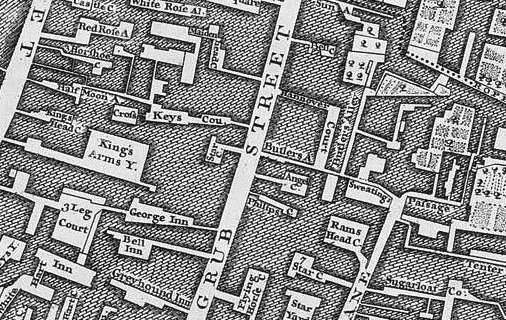
The street – its name possibly comes from a man called Grubbe or refers to a street infested with worms – was located in the parish of St Giles-without-Cripplegate outside the city wall. It northwards ran from Fore Street to Chiswell Street and had numerous alleys and courts leading off it.
Originally located in an area of open fields used for archery and so inhabited by bowyers and others associated with the production of bows and arrows, the relative cheapness of the land – due to its marshiness – later saw the Grub Street and its surrounds become something of a slum, an area of “poverty and vice”.
During the mid-17th century, it became known as a home for (often libellous or seditious) pamphleteers, journalists and publishers seeking to escape the attention of authorities.
And so began the association of Grub Street with writing “hacks”, paid line-by-line as they eked out a living in tawdry garrets (although how many actually worked in garrets remains a matter of debate). The word “hack”, incidentally, is derived from Hackney, and originally referred to a horse for hire but here came to refer to mediocre writers churning out copy for their daily bread rather than any sense of artistic merit.
Residents included Samuel Johnson (early in his career), who, in 1755 included a definition for it in his famous dictionary – “a street near Moorfields in London, much inhabited by writers of small histories, dictionaries and temporary poems, whence any mean production is called grubstreet”, and 16th century historian John Foxe, author of the famous Book of Martyrs.
The street, which was also referenced by the likes of Alexander Pope and Jonathan Swift as a symbol of lowbrow writing, was renamed Milton Street (apparently after a builder, not the poet) in 1830. Part of it still survives today but most of it disappeared when the Barbican complex was created between the 1960s and 1980s.
PICTURE: John Rocque’s map of 1746 showing Grub Street.