Apologies for the delay in posting this piece – next week we’ll post the final in this series!
The first underground railway system in the world, the London Underground – fondly known as the ‘Tube’ – is this year celebrating the 150th anniversary of its creation.
Born out of an idea to link the inner city with the various large rail termini on the outskirts, the first section of what is now the underground system – a six kilometre stretch between Paddington and Farringdon – opened on 9th January, 1863, and was run by the Metropolitan Railway, known less formally as the ‘Met’.
 It was constructed using the ‘cut and cover’ method in which streets were dug up and tracks laid in a trench before being covered by brick-lined tunnels and the street above replaced (the method was later abandoned, apparently due to the disruption it caused to traffic). The first trains were steam-driven locomotives and drew gas-lit wooden carriages behind them (the first journey was re-enacted earlier this year – see our earlier post here. Other events commemorating the 150th included a visit to Baker Street Station by Queen Elizabeth II, Prince Philip and the Duchess of Cambridge).
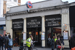
The idea proved a success – 26,000 people used the new railway every day during the first six months of its operation – and the Metropolitan District Railway opened a new line between Westminster and South Kensington (station is pictured) in December, 1868, while the first Tube tunnel under the Thames, from the Tower of London to Bermondsey, opened in 1880, and what is now the Circle Line was completed in 1884.
In December 1890, the world’s first deep-level electric railway opened, running between King William Street in the City and passing under the Thames to Stockwell. Ten years later the ‘Twopenny Tube’, more formally known as the Central London Railway, opened between Shepherd’s Bush and Bank (it was from this that the use of the word ‘Tube’ to describe the Underground system caught on).
The uniting of the system began the following year with the creation of the Underground Electric Railway Company of London and by World War I, all but the Met were within a single group organisation. The name Underground first appeared on stations in 1908, the same year electric ticket machines were introduced.
In 1933, the Underground came under the control of the London Passenger Transport Board – the same year that Harry Beck’s first diagrammatic map of the underground system appeared.
Stations in the system were used as air raid shelters during World War II – part of the Piccadilly Line was closed and used as a storage site for treasures from the British Museum. Following the war, the organisation running the system went through various name changes until the formation of London Underground in 1985.
The system has since expanded – the Victoria Line was opened in the late 1960s and the Jubilee Line a decade later – and now consists of more than 408 kilometres of railway lines and 275 stations which serve more than three million passengers a day – equating to more than a billion a year, the same as the entire national rail network.
For more on the history of the Underground, see our earlier 10 Questions with London Transport Museum curator Simon Murphy. Poster Art 150 – London Underground’s Greatest Designs runs at the London Transport Museum until October. Admission charge applies. For more (including the many events around the exhibition), see www.ltmuseum.co.uk/whats-on/events/events-calendar#posterart150.
For more, check out David Bownes’ Underground: How the Tube Shaped London or Andrew Martin’s Underground, Overground: A Passenger’s History of the Tube
 .
.


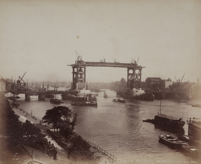
 Albury Street in Deptford, 1911. The image, taken by the London County Council, is just one of thousands which form part of a new free, online resource, Collage – The London Picture Archive. The world’s largest collection of images of London, the archive contains more than 250,000 images of London spanning the period from 1450 to the present day. It includes more than 8,000 historical photographs of life on the capital’s streets as well as major events – everything from the Great Fire of London in 1666 to the construction of Tower Bridge in the late 19th century. The photographs, maps, prints, paintings and films in the collection are all drawn from the collections of the City of London Corporation’s Guildhall Art Gallery and the London Metropolitan Archives in Clerkenwell. Other images shown here include (above right) ‘Street Life in London’, 1877 (taken by Adolphe Smith and John Thomson, this image was an early use of photography); (below) ‘Construction of the Metropolitan Railway (the first tube line)’, 1862 (taken at King’s Cross Station); and (far below), ‘The Construction of Tower Bridge’, 1891-1892 (taken from Tower Embankment). Collage – The London Picture Archive is free to access and available at