Located in an inlet where the River Neckinger enters the Thames just to the east of Tower Bridge, this dock has been used since the early middle ages.
St Saviour’s Dock
Lost London – Jacob’s Island…
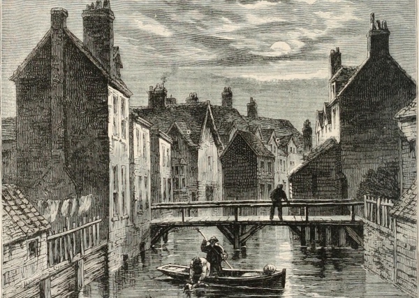
Famous for its mentions by Charles Dickens, Jacob’s Island – located in Bermondsey – was not actually a true island.
It was a small parcel of land formed into an “island” thanks to its location in a loop of the Neckinger River and, on the south side of the loop, a man-made ditch which was used as a mill run for Bermondsey Abbey.
 The “island” – which on a modern map was located just to the south of the street known as Bermondsey Wall West, east of Mill Street, west of George Row and north of Wolseley Street, was home to a notorious slum or “rookery” between the 18th and early 19th centuries,
It was most famously mentioned in Charles Dickens’ book, Oliver Twist and was where the notorious Bill Sikes died in the mud of ‘Folly Ditch’ – a reference to the ditch surrounding the island – as he attempted to elude the authorities.
Dickens describes Jacob’s Island in the book as a place “where the buildings on the banks are dirtiest and the vessels on the river blackest with the dust of colliers and the smoke of close-built low roofed houses, there exists the filthiest, the strangest, the most extraordinary of the many localities that are hidden in London”. In the preface to the 1867 edition of the book, he even wrote of its ongoing existence which was apparently doubted by one City alderman, saying “Jacob’s Island continues to exist (like an ill-bred place as it is) in the year one thousand eight hundred and sixty-seven, though improved and much changed”.
The slum itself existed until the late-1800s – much of it was razed in a fire of 1861 – in subsequent decades, the ditches surrounding it were filled in and the area redeveloped into warehouses.
The River Neckinger, incidentally, is one of London’s ‘lost rivers’. Its name means ‘devil’s neckerchief’ or ‘devil’s necklace’ – a reference to the hangman’s noose – and it is believed to refer in here to the gibbet from which pirates were hung close to the mouth of where the river entered the Thames at nearby St Saviour’s Dock and where their bodies left to deter others from taking a similar path.
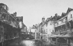
PICTURE: Top – Jacob’s Island and Folly Ditch, an engraving from a book published in 1873 (Internet Archive Book Images/licensed under CC BY-SA 2.0); Right – ‘Folly Ditch’, pictured here in about 1840.
10 sites from London at the time of the Magna Carta – 8. Bermondsey Abbey…
 Bermondsey Abbey, which was more than 130-years-old by the time King John put his seal to the Magna Carta in 1215, has an unusual connection to the unpopular king – it is one of a number of buildings in London which has, at various times in history, been erroneously referred to as King John’s Palace.
This suggestion – that it was a palace which was later converted into an abbey – may have arisen from a site on the former abbey grounds being known at some point in its history as King John’s Court (that name was said to commemorate the fact that King John visited the abbey).
Putting how King John’s name came to be linked with the abbey aside, we’ll take a quick look at the history of the abbey which rose to become an important ecclesiastical institution in medieval times.
While there was a monastic institution in Bermondsey as far back as the early 8th century, the priory which was here during the reign of King John was founded in 1082, possibly on the site of the earlier institution, by a Londoner named as Aylwin Child(e), apparently a wealthy Saxon merchant who was granted the land by King William the Conqueror.
In 1089, the monastery – located about a mile back from the river between Southwark and Rotherhithe – became the Cluniac Priory of St Saviour, an order centred on the French abbey of Cluny, and was endowed by King William II (William Rufus) with the manor of Bermondsey.
It was “naturalised” – that is, became English – by the first English prior, Richard Dunton, in 1380, who paid a substantial fine for the process. It was elevated to the status of an abbey by Pope Boniface IX in 1399.
It had some important royal connections – King John’s father, King Henry II and his wife Queen Eleanor celebrated Christmas here in 1154 (their second child, the ill-fated Henry, the young King, was born here a couple of months later), and Queen Catherine (of Valois), wife of King Henry V, died here in 1437. It was also at Bermondsey Abbey that Elizabeth Woodville, the widow of King Edward IV and mother of the two “Princes in the Tower”, died in 1492 following her retirement from court.
The abbey, which grew to have an enormous income thanks to its acquisition of property in a range of counties, survived until the Dissolution when, in 1537, King Henry VIII closed its doors. It was later acquired by Sir Thomas Pope who demolished the abbey and built a mansion for himself on the site (and founded Trinity College in Oxford apparently using revenues from the property). We’ll deal more with its later history in an upcoming post.
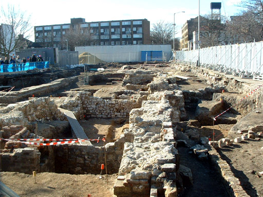
The ruins of the abbey were extensively excavated in the past few decades and some of the remaining ruins of the abbey can still be seen buildings around Bermondsey Square and a blue plaque commemorating the abbey was unveiled in 2010. Bermondsey Street runs roughly along the line of the path which once led from the abbey gates to the Thames and the abbey had a dock there still commemorated as St Saviour’s Dock. The abbey’s name is commemorated in various streets around the area.
For more on the history of the Magna Carta, see David Starkey’s Magna Carta: The True Story Behind the Charter.
PICTURE: An archaeological dig at the ruins of Bermondsey Abbey in 2006. Zefrog/Wikipedia.
