Former tea clipper Cutty Sark is finally nearing the end of £50 million restoration project in its dry dock at Greenwich. The ship, almost destroyed in a fire in May 2007 which broke out while the ship was undergoing conservation work, is expected to reopen to the public next year – just in time for the Olympics. The extensive restoration project recently marked the completion of the ship’s intricate gold leaf “gingerbread”, located on the upper hull on either side of the bow, and the figurehead (pictured). The Cutty Sark undertook her first voyage – to Shanghai – in 1870 and continued to ply the waters between China and the UK until 1878 when steamships took over the route. The ship continued, however, to operate as a cargo vessel (including hauling wool between Australia and the UK) until the early twentieth century when she was eventually restored and used as a training ship. The Cutty Sark, which last went to sea in 1938, came to London in 1951 as part of the Festival of Britain celebrations. She was saved from the scrapyard in 1954 when she took up her position in the drydock at Greenwich and was opened to the public in 1957. For more – including a diary of the restoration work – see www.cuttysark.org.uk.
Author: exploringlondon
London Pub Signs – The London Apprentice
Sitting on the bank of the Thames at Old Isleworth in the city’s west stands The London Apprentice public house.
The pub’s licence dates back to at least 1731 and it has been associated with the likes of such luminaries as King Henry VIII (it’s suggested he met Catherine Howard here – she was later imprisoned in nearby Syon House), King Charles I and King Charles II (the latter apparently cavorted with his mistress, actress Nell Gwynne, here), as well as the ill-fated Lady Jane Grey and Lord Protector Oliver Cromwell.
Others whose names come up in reference to the pub include the ever-present author Charles Dickens (this is said to have been one his favorite pubs) and notorious highwayman Dick Turpin.
While there remain some doubts over its origins, the name of the pub – which stands opposite the small isle known as the Isleworth Ait – is said to stem from the fact that it was here that London apprentices, having faithfully served their masters, came to while away the hours in their downtime. They are said to have entertained themselves by playing about in decorated barges on the river.
There is said to be a tunnel, now blocked, which links the pub with the nearby All Saint’s Church – the story goes that this was used by smugglers to get their contraband into the pub’s cellars.
For more information or to pay a visit, see www.thelondonapprentice.co.uk.
LondonLife – Clive of India in silhouette…
Located on the steps at the end of King Charles Street in Whitehall, this somewhat controversial statue of Robert Clive, known to many as Clive of India, stands outside what was the India Office (and is now the Foreign and Commonwealth Office). The statue was erected in 1912, apparently it was suggested by Lord Curzon, a former viceroy to India.
Where is it? #9
The ninth in the series in which we ask you to identify where in London this picture was taken and what it’s of. If you reckon you know the answer, leave a comment below. We’ll reveal the answer early next week. Good luck!
Yes, as it seems everyone knew (well done Joe from Kew, Mike Paterson, and Gillian Blackman on Facebook) this is an image of Chiswick House, a magnificent example of Palladian architecture in London’s west. Inspired after a Grand Tour of Italy and Greece (and by the work of the Italian Renaissance architect Andrea Palladio), the home was built by the 3rd Duke of Burlington and completed in 1729. It wasn’t designed as a residence but as a grand villa where the Duke could show off his extensive art collection and entertain friends. We’ll be taking a more detailed look in the house and gardens in a future post. In the meantime, you can follow this link for more.
Around London – Leading ladies of the 18th century at NPG; “at risk” in London; and, Antarctic images at the Queen’s Gallery…
• A new exhibition featuring some of London’s leading ladies of the eighteenth century opens at the National Portrait Gallery today. The First Actresses: Nell Gwyn to Sarah Siddons is the first exhibition devoted to eighteenth century actresses and features 53 portraits depicting the likes of Gwyn and Siddons as well as Lavinia Fenton, Mary Robinson and Dorothy Jordan. Highlights of the exhibition include a little known version of Joshua Reynolds’ portrait of Sarah Siddons as the “tragic muse”, William Hogarth’s The Beggar’s Opera and Thomas Gainsborough’s portraits of Giovanna Bacelli and Elizabeth Linley. The exhibition reveals the key role these women played in the celebrity culture found in London (and elsewhere) during the period. As a counterpoint, an accompanying exhibition displays photographs and paintings of some of today’s actresses. Runs until 8th January (an admission charge applies). For more information on the exhibition or the programme of accompanying events, see www.npg.org.uk.
• Cemetery in Hackney and Kensal Green, a park in Hounslow and a Piccadilly property formerly used as the Naval and Military Club are among the “priority sites” listed on English Heritage’s annual Heritage At Risk Register. Released earlier this week, the register’s 10 London”risk priority sites” include London’s first metropolitan cemetery – Kensal Green (All Souls) – which dates from 1833, Gunnersbury Park in West London – featuring a large country home known as Gunnersbury Park House, it was built in 1801-28 and later remodelled, and a mansion at 94 Piccadilly – built in 1756-60 for Lord Egremont, it was later used at the Military and Naval Club and is now for sale. Others on the list include Abney Park Cemetery in Hackney – laid out in 1840, it is described as London’s most important Nonconformist cemetery, a medieval manor farm barn in Harmondsworth in London’s outer west, Tide Mill in Newham, East London, and the entire Whitechapel High Street and Stepney Green conservation areas. For more information, see www.english-heritage.org.uk/caring/heritage-at-risk/.
• On Now: The Heart of the Great Alone: Scott, Shackleton and Antarctic Photography. Opening at the Queen’s Gallery, Buckingham Palace, tomorrow, the exhibition marks the centenary of Captain Robert Scott’s ill-fated expedition to the South Pole and features a collection of photographs presented to King George V by the official photographers on Scott’s expedition of 1910-13 and Ernest Shackleton’s expedition of 1914-16 as well as unique artifacts including the flag given to Scott by Queen Alexandra (the widow of King Edward VII) which was taken to the Pole. Highlights include Herbert Ponting’s images The ramparts of Mount Erebus and The freezing of the sea and Frank Hurley’s stunning images of Shackleton’s ship Endurance as it was crushed by ice. Runs until 15th April, 2012 (admission charge applied). For more, see www.royalcollection.org.uk.
The Royal Parks – 5. The Regent’s Park
A former hunting chase, The Regent’s Park in London’s north-west was extensively developed in the 19th century and remains a good – if not complete – example of a Regency landscape.
As with many of London’s Royal Parks, Regent’s Park (it’s formal name is actually The Regent’s Park but we’ll shorten it for our purposes here) once served as King Henry VIII’s hunting grounds – he seized the park, then known as Marylebone Park Fields after the nearby village and boasting thick woods as well as more open forests, from the Abbey of Barking in 1538.
Used by royalty for the next 50 years, it remained largely unaltered until after the Civil War when, between 1649 and 1660, the Commonwealth ordered many of the trees to be chopped down to pay debts. It was restored to royal ownership with the restoration of the monarchy but, with hunting falling out of fashion, was then leased out to tenant farmers.
It was John Nash who created the park that we know and love today. Friend of the Prince Regent (later King George IV), he was among a number of architects who responded to the Prince Regent’s calls for the creation of a new design featuring a palace for himself.
Nash’s original designs included a round park featuring a lake and canal and surrounded by as many as 56 villas and a palatial summer home for the Prince Regent which would be linked to his other home at St James’s by a processional road.
But only eight of the villas were ever built and only two of them – St John’s Lodge and The Holme – remain (both are private residences but part of the lodge’s gardens are open to the public) while the plans for the Prince Regent’s palace were put on hold when he turned his attention to developing Buckingham Palace instead. The canal, meanwhile, was moved to the park’s northern boundary where it still stands today (see our earlier entry on Regent’s Canal) while the processional route Nash had proposed became Regent Street.
While the park was initially only for the exclusive use of residents and what Royal Park’s call the ‘carriage set’, in 1835, the eastern part of the park was opened to the public for two days a week. Other sections of what is now included in the park, including Primrose Hill, were opened later.
Meanwhile, the fact most of the villas had never been built had left a large amount of free space and so both the Zoological Society and the Royal Botanic Society moved in – the latter laying out what is the Inner Circle with lawns and a lake of its own. Another society to operate in the park was the Royal Toxophilite Society which introduced archery there.
Not much has changed since but for the creation of Queen Mary’s Gardens in the 1930s – these were laid out on the space formally occupied by the Royal Botanic Society which had decided not to renew its lease. The Open Air Theatre performances, which are still held in the gardens today, started at about the same time. The park was damaged by bombing during World War II but has been fully restored.
Other facilities now in the 166 hectare (410 acre) park include a sports facility known as The Hub as well as several cafes, tennis courts and boat hire. The London Zoo, of course, also remains there.
WHERE: The Regent’s Park (nearest tube station is Regent’s Park); WHEN: 5am to at least 4pm (closing times vary depending on the month); COST: Free entry; WEBSITE: www.royalparks.gov.uk/The-Regents-Park.aspx
LondonLife – The Thames Barrier
Laid like an iron necklace across the Thames, as of May this year, the Thames Barrier has protected central London from flooding 119 times since it went operational in 1982. The barrier spans 520 metres of the river near Woolwich, east of the City, and is one of the largest moveable flood barriers in the world. It features 10 steel gates, each of which weighs 3,000 tonnes, which can be raised or lowered. They stand as high as a five-storey building when up and, while you may not think they look it, the piers, which are covered with a protective ‘skin’ of stainless steel, are wide enough apart to accommodate the largest of ships. There are regular boat trips to the barrier from central London and there is an information centre about the barriers which includes a cafe (boats don’t stop at the Thames Barrier Pier, so this can’t be accessed from the river itself). For more on the barrier and the information centre, see www.environment-agency.gov.uk/homeandleisure/floods/38353.aspx.
Famous Londoners – Simon of Sudbury
Recently making news headlines thanks to the work of Adrienne Barker of the University of Dundee in reconstructing his face, Simon of Sudbury wasn’t born in London and, in fact, spent much of his early life elsewhere. But, as Bishop of London and Archbishop of Canterbury, he was a key figure in the 14th century city and it was in London that he eventually met his grisly death during the Peasant’s Revolt.
Simon Theobold was born around 1316 – the son of a wealthy Norfolk merchant – and, while details of his early life are scant, it has been suggested he studied at Cambridge before eventually entering the service of William Bateman, the Bishop of Norwich. He apparently became caught in the middle of a dispute between the bishop and the Abbot of Bury St Edmunds (the details of which we don’t have time to get into here) and it was this which is said to have led to the issuing of a royal order for his arrest, a move which forced him to flee England for the papal court at Avignon.
He quickly came to the attention of the popes and took on an official role, the reward for which was the income from various positions in the English church including Chancellor of Salisbury. In 1356, Pope Innocent VI sent him on a peace mission to King Edward III and it was during this mission that he came to the attention of the king. Having never been formally outlawed, he was apparently forgiven his earlier crimes and was soon acting on behalf of the king including at the Papal court.
In 1361, Simon was made Bishop of London and spent the next 10 years in the role, as well as continuing to act for the king, notably as a diplomat.
In 1375 following the death of incumbent William Whittelsey, he was elevated to the position of Archbishop of Canterbury. His time as archbishop was somewhat troubled – as well as facing accusations of being too close to the king, he also faced criticism over his treatment of Bible translator John Wycliffe – but it was his role in secular politics which led to his demise.
Following the accession of King Richard II in 1377, in 1380 Simon was appointed chancellor, a position which meant he bore the ultimate responsibility for the imposition of an extremely unpopular new poll tax. In 1381, there were calls for his death at the outbreak of rebellion in Kent, notably when the rebels entered Canterbury Cathedral. But as the crisis now known as the Peasant’s Revolt gained momentum, Sudbury remained with the king in the Tower of London where he apparently counselled a hard line.
King Richard II when to parley with the traitors at Mile End on 14th June and there apparently indicated that action would be taken against traitors around him (Wat Tyler was killed when the king again met the rebels, this time at Smithfield, the following day). A group of rebels subsequently stormed the tower and dragged out Sudbury and the treasurer, Sir Robert Hales. Taken to Tower Hill, they were there beheaded. Sudbury’s head, which apparently had a skullcap nailed to his skull, was impaled on a lance and put on display over London Bridge. His body was buried in Canterbury Cathedral.
The skull, meanwhile, was apparently taken down by a Sudbury man and taken back to his home town where it was kept at St Gregory’s Church. Some 630 years later, following an approach by Sudbury locals, forensic artist Adrienne Barker from the University of Dundee was asked to recontruct Simon’s head.
Following some CT scans of the skull, Barker – who carried out the work as part of her MSc Forensic Art studies under the tutelage of renowned facial reconstruction expert Professor Caroline Wilkinson – used state-of-the-art reconstruction techniques to recreate Sudbury’s facial features and complete a series of 3-D bronze-resin casts of his head. The models, one of which will be on permanent display at St Gregory’s Church in Sudbury alongside Simon’s skull, were unveiled in September.
PICTURE: University of Dundee
Treasures of London – The London Stone
The London Stone was once considered to be one of the City’s most important relics with the very existence of the city depending on its survival. Yet, hidden away behind an iron grille set into the front of a building at 111 Cannon Street, the block of Clipsham limestone is these days all but forgotten, occupying an ignominious position opposite the gleaming new Cannon Street Station.
The stone’s origins lie shrouded in mystery but the legend, propagated in the 19th century, goes that it once formed part of an altar built by Trojan wanderer and founder of London, Brutus. Yet, according to the Museum of London, the saying often associated with the legend – “So long as the Stone of Brutus is safe, so long will London flourish” – was apparently invented in 1862.
It has been suggested the stone, which is a Grade II* listed structure, may be a relic of the city of the Roman city of Londinium, although no-one seems to know for sure. The earliest mention of it was apparently around 1100 AD and it was subsequently associated with some of London’s most famous characters.
It is said that Jack Cade, leader of the 15th century Kentish rebellion, struck it with his sword after entering London in a symbolic gesture designed to reflect his taking control of the city and naming himself ‘Lord of London’. The poet William Blake is said to have believed it to be associated with druidism – perhaps it was part of an altar? – and even the great 17th century architect Christopher Wren had a view on it – he thought it was part of a Roman ruin after seeing its foundations.
One widely believed and circulated theory was that it was the stone from which all distances from London were measured during Roman times. Its heritage listing says it may have been a Roman milestone. It has also been suggested it is the base of an Anglo-Saxon waymarker or cross.
The stone was located in its current position after World War II. Since the 18th century it had been set into the wall of a Wren-designed church, St Swithin London Stone, which had stood on the site where the stone now sits but which was demolished in 1962 after being bombed in the Blitz. Prior to being moved to the church, the stone stood upright on the south side of Cannon Street. It was moved to the church after becoming a traffic hazard.
There has been talk in recent years of moving the stone to a better home but for the moment it remains behind the grill by the footpath.
Around London: Taking to the skies over the Thames; a new plumber in Cannon Street; and, new images of war at IWM…
• The proposed cable car crossing of the Thames will be sponsored by airline Emirates in a 10-year, £36 million deal announced last Friday. To be known as the ‘Emirates Air Line’, the cable car will link the DLR station Royal Victoria with the Jubilee Line station North Greenwich and will involve the creation of two new cable car stations bearing the sponsor’s name – Emirates Greenwich Peninsula on the south bank and Emirates Royal Docks on the north. It is the first time a corporate brand will appear on the Tube map. Transport for London has said the new service could be operational by summer 2012 (although whether it will be ready for the Olympics remains uncertain). It will feature 34 cable car gondolas and ferry as many as 2,500 passengers across the river every hour with an expected two million passengers to use the service each year. The journey is expected to take five minutes and will see the gondolas travelling at a height of 160 feet above the river. The sponsorship deal was announced by the Mayor of London, Boris Johnson, along with Tim Clark, president of Emirates Airline, and Mike Brown, managing director of London Underground and Rail.
• The Duke of Gloucester unveiled a new statue, called Plumber’s Apprentice, at Cannon Street Station last week to mark the 400th anniversary of the granting of a Royal Charter to London’s Worshipful Company of Plumbers. Sculpted by Martin Jennings (he also created the statue of British poet Sir John Betjeman that now stands in St Pancras Station), the seven foot tall bronze statue is said to underline the livery company’s ongoing commitment to train young plumbers. The company, which was formed in 1365, received its charter from King James I in 1611. From 1690, following the destruction of the company’s previous hall in the Great Fire of London, it was based in a building on the site of the railway station. In 1863, it was forced to again move when the hall was compulsorily purchased to make way for the railway. Also present at the unveiling were the Lord Mayor of London, Michael Bear, and the Lady Mayoress, herself a sculptress and liverymen of the Worshipful Company of Plumbers. For more, see www.plumberscompany.org.uk.
• On now: Shaped by War: Photographs by Don McCullin. The Imperial War Museum is hosting the largest ever exhibition of the life and works of acclaimed photographer Don McCullin. The display features some 250 photographs including rarely seen before portraits of anonymous victims of war, contact sheets, objects, magazine and personal memorabilia. Conflicts covered include those of the Cold War, in places like Vietnam and Cambodia, Bangladesh and the Middle East – the latter include images from the Gulf War and the 20o3 invasion of Iraq. There is also a newly commissioned video in which McCullin talks about the exhibition. Runs until 15th April, 2012. An admission charge applies. For more, see www.iwm.org.uk.
The Royal Parks – 4. St James’s Park
The fourth in a line of parks stretching from Kensington Palace to Westminster, St James’s Park largely owes its foundation to King James I.
Given its early history is covered in our earlier post, we’ll skip forward to the time of King Charles II when, under to instruction of Frenchman Andre Mollet, the park was redesigned with new landscaping including wide lawns, avenues of trees and a wide, centrally positioned canal. It was King Charles II who also opened the park up to the public (he even mingled with them there along with his mistress Nell Gwynn). Interestingly the first pelicans were also introduced to the park around this time when the Russian ambassador presented a pair of pelicans to the king.
In the 18th century, Horse Guards Parade was added to the park by filling in one end of the park’s canal and was later used for parades. The ceremonies of Beating Retreat and Trooping the Colour are still held there today.
The next major changes came in the 19th century when in 1827-28, architect John Nash oversaw a more romantically inspired renovation, including the transformation of the canal into a natural looking lake and the addition of winding paths, as part of his grand scheme which still shapes much of London today.
It was also at this time that The Mall (which like Pall Mall takes it name from the game of Pelle Melle – see our earlier post) was transformed into a grand processional route (it was opened to traffic later, in 1887). The park, bounded to the west by Buckingham Palace, also takes in the Queen Victoria Memorial – completed in 1914 to replace the Marble Arch which was moved to its current location at the corner of Oxford Street and Park Lane in 1851 – and flower beds which are planted annually with 12,000 geraniums, the color of which is chosen to match the guardsmen’s tunics.
Meanwhile, in 1837, the Ornothological Society of London erected a cottage for the birdkeeper (the thatched cottage can still be seen there today and the post of birdkeeper still exists). The first bridge was placed across the lake in 1851 (and replaced in 1951 with the one that now stands there).
Little has changed in the 23 hectare (58 acre) park since Nash’s day. Newer facilities include a restaurant and a playground at the western end.
WHERE: St James’s Park (nearest tube station is St James’s Park); WHEN: 5am to midnight daily; COST: Free entry; WEBSITE: www.royalparks.gov.uk/St-Jamess-Park.aspx
PICTURE: © Anne Marie Briscombe (courtesy Royal Parks)
LondonLife – Leaves make for strange designs in the Strand…
What’s in a name?…Strand
Now one of the major thoroughfares of the West End, the origins of the roadway known as the Strand go back to the Roman times leading west out of the city.
Later part of Saxon Lundenwic which occupied what is now the West End, it ran right along the northern shore of the Thames and so became known as the Strand (the word comes from the Saxon word for the foreshore of a river). During the following centuries the river was pushed back as buildings were constructed between the road and the river, leaving it now, excuse the pun, ‘stranded’ some distance from where the Thames flows.
Sitting on the route between the City of London and Westminster, seat of the government, the street proved a popular with the wealthy and influential and during the Middle Ages, a succession of grand homes or palaces was built along its length, in particular along the southern side.
All are now gone but for Somerset House – originally the home of the Dukes of Somerset, it was built in the 16th century but rebuilt in the 18th century after which it served a variety of roles including housing the Navy Office, before taking on its current role as an arts centre. Others now recalled in the names of streets coming off the Strand include the Savoy Palace, former residence of John of Gaunt which was destroyed in the Peasant’s Revolt, and York House, once home of the Bishops of Norwich and later that of George Villiers, favorite of King James I (see our earlier Lost London entry on York Watergate for more).
After the aristocracy decamped further west during the 17th and 18th centuries, the road and surrounding area fell into decline but was resurrected with a concerted building effort in the early 19th century (this included the creation of the Victoria Embankment which pushed the Thames even further away) which saw it become a favorite of the those who patronised the arts, including the opening of numerous theatres. Among those which still stand on the Strand today are the Adelphi and Savoy Theatres (this was apparently the first in London to be fitted with electric lights and sits on a site once occupied by the Savoy Palace).
Among the other landmarks along the Strand are the churches of St Mary-le-Strand (the present building which sits on what amounts to a traffic island) dates from 1717 and was designed by James Gibbs, and St Clement Danes, designed by Sir Christopher Wren and completed in 1682 (it is now the Central Church of the Royal Air Force). The Strand is also home to the Victorian-era Royal Courts of Justice (it boasts more than 1,000 rooms), Australia House (home of the oldest Australian diplomatic mission), the Strand Palace Hotel (opened in 1907) and Charing Cross Railway Station.
Where is it? #8
This is the eighth in our series in which we ask you to identify where in London this picture was taken and what it’s of. If you reckon you know the answer, leave a comment below. We’ll reveal the answer early next week. Good luck!
Around London: The East India Company at National Maritime Museum; Open days at London Transport Museum’s depot; and, Atkinson Grimshaw at the Guildhall Art Gallery…
• The National Maritime Museum in Greenwich has launched five month-long festival looking at the East India Company and the mark it’s left on London and the world. The festival, which was launched late last month as a new gallery, Traders: The East India Company and Asia, opened its doors at museum, features musical performances, film screenings, games, discussions, story-telling and debates surrounding the company and its legacy as well as ‘curry and a pint’ nights and tea parties. Also included are two days of celebrations marking Diwali, the Hindu Festival of Lights, on 12th November, and Chinese New Year on 18th February. For more on the events and the museum, see www.nmm.ac.uk.
• London Transport Museum’s Depot in Acton is holding a family open weekend this Saturday and Sunday with ‘make and take’ workshops, object handling sessions and rides on the open air miniature railway and life-sized heritage vehicles. Among those on hand to answer all your questions will be London’s Emergency Response Unit. Open between 11am and 5pm both days (last admission 4pm). An admission charge applies. To book or to find out more information, see www.ltmuseum.co.uk/whats-on/museum-depot/events.
• On Now: Atkinson Grimshaw: Painter of Moonlight. The first major show of Grimshaw’s work for more than 30 years, this exhibition at the Guildhall Art Gallery includes more than 60 paintings from his earliest Pre-Raphaelite inspired landscapes to the Impressionist style seascapes of his last years along with drawings, manuscripts and photographs on loan from public and private collections and descendants of the artist. Grimshaw (1836-1893) was a popular Victorian artist known for his evocative scenes of the urban environment at night and for his landscapes. Runs until 15th January (admission charge applies). There is also a special late viewing (the gallery’s first) on 21st October. For more on the exhibition, see www.guildhallartgallery.cityoflondon.gov.uk/gag/.
The Royal Parks – 3. Green Park
Perhaps the most overlooked and least celebrated of central London’s Royal Parks, Green Park (officially The Green Park) is a peaceful oasis of leafy trees between the bustle of Piccadilly and traffic of Constitution Hill and part of an unending swathe of green which connects Kensington Gardens with, eventually, St James’ Park.
Originally meadowland used for hunting, the earliest known mention of the area where the park now stands was apparently in 1554 when it was believed to be a staging point for Thomas Wyatt (the younger) who led a group of rebels protesting against the marriage of Queen Mary I to King Philip II of Spain. The unfortunate – and unsuccessful (in terms of his rebellion at least) – Wyatt was later beheaded for treason.
In 1668, King Charles II had the park enclosed with a brick wall and stocked with deer, as well as having a ranger’s lodge and icehouse built (to keep his drinks cool when entertaining in summer). While it was initially known as Upper St James’s Park, by 1746 Green Park had its own name. It’s not really known what prompted the name change but the unofficial story is that Queen Catherine of Braganza, wife of King Charles II, found out that her philandering husband had picked some flowers there for another woman – a milkmaid. In revenge, she had every flower in the park pulled up with orders they were not to be replanted. To this day, while some 250,000 daffodils bloom here in spring, there remain no formal flowerbeds in the park.
The 47 acre (19 hectare) park, which was also used on occasion as a duelling ground, underwent further development at the beginning of the following century with the creation of the ornamental Tyburn Pool near the centre of the park.
Queen Caroline, the wife of King George II, meanwhile, had a reservoir built to supply water to St James’s Palace and Buckingham Palace (it was known as the Queen’s Basin) as well as a library and the Queen’s Walk. Planted in 1730, this runs along the eastern side of the park and helped to turn it into a fashionable place in which to be seen (and led to the building of many a mansion in nearby Piccadilly).
Other buildings in the park have included two temporary ‘temples’ – the Temple of Peace (erected in 1749 to mark the end of the War of Austrian Succession) and the Temple of Concord (erected in 1814 to mark 100 years of the rule of the Hanoverian dynasty). Both of these, believe it or not, burnt down during the celebrations they were built for.
The park, which underwent a redesign in which the first trees were planted in the 1820s as part of architect John Nash’s grand plans for St James’s Park, was opened to the general public in 1826 but by then many of its earlier features – including the ranger’s house, Tyburn Pool and the Queen’s Basin – were already gone.
In more recent times, war memorials have been added to the park – the maple-leaf daubed, Pierre Granche-designed memorial to Canadian soldiers in 1994 (Canada is also remembered in Canada Gate on the park’s south side, installed in 1908 to mark the nation’s contribution to the Empire), and a set of memorial gates on Constitutional Hill at the park’s western end which is dedicated to the five million people from the Indian Sub-Continent, Africa and the Caribbean who served in World War II in 2004. The park also features the ‘Diana fountain’, installed in 1952 by the Constance Fund (and currently undergoing restoration).
On 14th June, a 41 royal gun salute is fired here to mark the Queen’s birthday. Salutes are also fired here for the State Opening of Parliament in November or December, Remembrance Sunday, and for State Visits.
WHERE: Green Park (nearest tube station is Green Park and Hyde Park Corner); WHEN: daily; COST: free; WEBSITE: http://www.royalparks.gov.uk/Green-Park.aspx
PICTURE: Courtesy of Royal Parks. © Anne Marie Briscombe
LondonLife – New Sheriffs in the City…
The two new sheriffs of the City of London – Alderman Alan Yarrow and Wendy Mead CC (pictured here second and fourth from left with Lord Mayor Michael Bear between them) – were admitted into office in a ceremony at Guildhall last week following their election in June by the City livery companies. The office of sheriff dates back to the Middle Ages and, until the institution of the mayoralty in 1189, sheriffs or ‘shire reeves’ were charged with governing the city as the king’s representatives, collecting royal revenues and enforcing royal justice. The role now includes ensuring the smooth running of the Central Criminal Court (housed at the Old Bailey), attending the Lord Mayor as he carries out his official duties and presenting petitions from the City to Parliament at the Bar at the House of Commons. Meanwhile, the City of London announced on Monday that Alderman David Wootton, himself a former sheriff (as all Lord Mayors must be) as well as a past master of of the Worshipful Company of Fletchers and of the Worshipful Company of Solicitors, has been elected the 684th Lord Mayor of the City of London. He takes office on Friday, 11th November (the Lord Mayor’s Show takes place the following day). For more, see www.cityoflondon.gov.uk.
PICTURE: Courtesy of City of London Corporation.
London Pub Signs – The Queen’s Larder
In the first of an occasional series looking at the story behind some of London’s pub signs, we take a look at The Queen’s Larder in Queen Square, Bloomsbury.
The origins of the pub go back to the early 18th century – around 1710 – when there was known to be an alehouse on the site now occupied by the tavern. The story goes that as King George III (aka the ‘Mad King George’ depicted in the film of the same name) began to be affected by mental illness he was brought to a house in Queen Square where he stayed and was treated by a Dr Willis.
While he was undergoing this treatment – which was apparently initially successful, his wife Queen Charlotte rented an underground cellar below the alehouse and there stored some of the king’s favorite delicacies.
When a tavern was later built on the site, it was named The Queen’s Larder in honor of the role it had played in providing a storehouse for his treats.
The square itself contains a statue which was believed to be of Queen Anne – after whom the square was renamed (it had previously been known as Devonshire Square) – but it is now thought that the statue may in fact be of Queen Charlotte.
Where is it? #7
This is the seventh in our series in which we ask you to identify where in London this picture was taken and what it’s of. If you reckon you know the answer, leave a comment below. We’ll reveal the answer early next week. Good luck!
No takers this week (are we making them too hard?) The answer is that this is the steeple of the St Marylebone Parish Church near Regent’s Park. Consecrated in 1817 and designed by Thomas Hardwick (a clerk of works to King George III), it was built after the previous church on the site had become too small. Among the many famous people the church has associations with are the poets Robert Browning and Elizabeth Barrett – they were married here in 1846, Elizabethan philosopher Francis Bacon – he was married in one of the previous churches in 1606, and Lord Byron – he was christened in the previous church in 1778. The church is also depicted in the marriage scene in William Hogarth’s The Rake’s Progress. For more on the origins of the word Marylebone, see our previous entry here…
Treasures of London – Harrison’s timekeepers
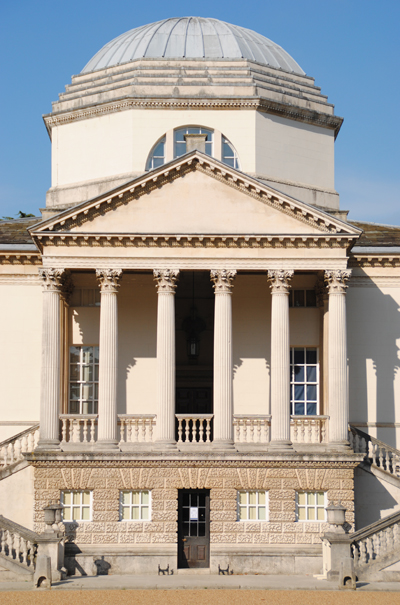
A series of four marine timekeepers which eventually solved the ‘problem’ of longitude – revolutionising sea travel by allowing mariners to accurately locate their position – are housed at the Royal Observatory in Greenwich.
The three clocks and one watch were designed by John Harrison, a working class joiner from Lincolnshire who made it his life’s mission to design a device which would keep accurate time at sea.
Calculating longitude – an east-west position on the earth – is relatively simple. Because time moves forward one hour for every 15 degrees one travels in an eastward direction (or back an hour for every 15 degrees one travels westward), it’s possible to calculate a position by simply knowing the local time at two different places on earth.
The problem was that the pendulum clocks of the 1600s were affected by changes in temperature and humidity and couldn’t keep accurate time on board a ship meaning that while a mariner might know the local time, he could not get an accurate measurement of time elsewhere to compare it to.
While mariners could use the ‘lunar distance method’ to measure longitude – this involved measuring the motion of the moon relative to the stars – it relied on clear skies and was not very accurate. So in 1714 the British Government announced it would award a prize of £20,000 to anyone who could come up with a solution to longitude which was accurate to within half a degree (or two minutes).
Clockmaker John Harrison was among those who took up the challenge (his somewhat tragic story is told in great detail in Dava Sobel’s terrific 1995 book Longitude: The True Story of a Lone Genius Who Solved the Greatest Scientific Problem of His Time). His first effort, known simply as H1, was constructed between 1730 to 1735 and, using a counterbalanced spring mechanism making it independent of gravity, was successfully tested on a voyage to Lisbon.
But Harrison wasn’t satisfied and began work on H2 in 1737 before, after realising its shortcomings three years later, starting work on another clock, H3, in 1740. He worked on this for 19 years but it failed to meet the accuracy requirements of the Board of Longitude which was charged with looking overseeing the awarding of the £20,000.
In 1753, Harrison asked a London watchmaker John Jefferys to create a watch to his designs, initially for his own personal use. But he soon discovered that with a few improvements, H4 – which looks like a large pocketwatch (see picture), could be the answer he was looking for.
In 1761 and 1764, Harrison’s son William took the watch on two voyages to the West Indies, yet, despite the fact that its accuracy was well within the requirements of the Board of Longitude, the board initially refused to pay up. After much wrangling Harrison was finally paid £10,000 but told that to obtain the other half of the money, he would have to create at least two more copies of H4.
Harrison went on to make one copy – H5 – while watchmaker Larcum Kendall, made another, K1, at the direction of the Longitude Board. When Harrison suggested that Kendall’s K1 could be considered the second of the two copies he was required to make, the board rejected the idea. Harrison then appealed directly to the king, George III, and finally to parliament before he was eventually awarded a further £8,750 in 1773.
Kendall’s watch, meanwhile, was taken by Captain James Cook on a three year voyage as far afield as Antarctica. It was a test which proved beyond all doubt the accuracy of the timekeepers. A year after Cook’s return in 1775, John Harrison died in his house in Red Lion Square on 24th March, 1776. It is not known whether he knew of the success of the timekeeper taken on Cook’s voyage.
Harrison’s four timekeepers are now housed at the Royal Observatory where the intriguing story of their creation is told.
WHERE: Royal Observatory, Blackheath Avenue, Greenwich (nearest DLR stations are that of Greenwich and Cutty Sark and it can also be reached by river – stop at Greenwich Pier); WHEN: 10am to 5pm (last admission 4.30pm) daily; COST: £7 adult/£5 concessions/free for children 15 and under (annual passes available – £10 an adult/£7.50 concessions) ; WEBSITE: www.nmm.ac.uk/places/royal-observatory/
PICTURE: Courtesy of the Royal Observatory, Greenwich


