This City of London street runs north-south from the junction of Newgate Street, Holborn Viaduct and Old Bailey to West Smithfield. Its name comes from those who once travelled along it.
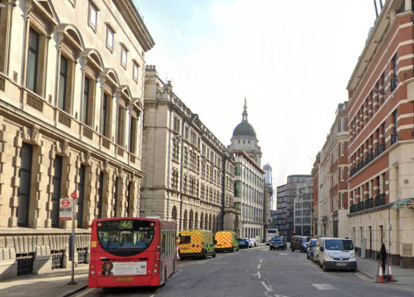
Looking south down Giltspur Street, with the dome of the Old Bailey visible, in 2018. PICTURE: Courtesy of Google Maps
An alternative name for the street during earlier ages was Knightrider Street which kind of gives the game away – yes, the name comes from the armoured knights who would ride along the street in their way to compete in tournaments held at Smithfield. It’s suggested that gilt spurs may have later been made here to capitalise on the passing trade.
The street is said to have been the location where King Richard II met with the leaders of the Peasant’s Revolt who had camped at Smithfield. And where, when the meeting deteriorated, the then-Lord Mayor of London William Walworth, ending up stabbing the peasant leader Wat Tyler who he later captured and had beheaded.
St Bartholomew’s Hospital can be found on the east side of the street. On the west side, at the junction with Cock Lane is located Pye Corner with its famous statue of a golden boy (said to be the place where the Great Fire of London was finally stopped).
There’s also a former watch house on the west side which features a monument to the essayist late 18th century and 19th century Charles Lamb – the monument says he attended a Bluecoat school here for seven years. The church of St Sepulchre-without-Newgate stands at the southern end with the Viaduct Tavern on the opposite side of the road.
The street did formerly give its name to the small prison known as the Giltspur Street Compter which stood here from 1791 to 1853. A prison for debtors, it stood at the street’s south end (the location is now marked with a City of London blue plaque).
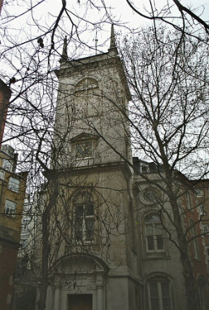
This tower is a survivor and was originally part of the rebuilt Church of St Olave, Old Jewry.
The medieval church, which was apparently built on the site of an earlier Saxon church, originally dated from 12th century. Its name referred to both the saint to whom it was dedicated – the patron saint of Norway, St Olaf (Olave) – and its location in the precinct of the City that was largely occupied by Jews (up until the infamous expulsion of 1290).
The former tower of St Olave, Old Jewry. PICTURE: Mark C Grant (public domain).
The church, which is also referred to as Upwell Old Jewry (this may have related to a well in the churchyard), was the burial place of two former Lord Mayors – mercer Robert Large (William Caxton was his apprentice) and publisher John Boydell (who apparently washed his face under the church pump each morning). Boydell’s monument was later transferred to St Margaret Lothbury.
The church was sadly destroyed in the Great Fire of 1666 but it was among those rebuilt under the eye of Sir Christopher Wren in the 1670s. It’s from this rebuilding that the current tower dates.
At this time, the parish was united with that of St Martin Pomeroy (which had already shared its churchyard and which was also destroyed in the Great Fire).
Wren’s church was eventually demolished in 1887 as moves took place to consolidate church parishes under the Union of Benefices Act – the parish was united with that of St Margaret Lothbury and proceeds from the sale were used to fund the building of St Olave, Monor House. It’s worth noting that a Roman pavement was found on the site after the church demolition.
The tower (and the west wall), meanwhile, survived. The tower was subsequently turned into a rectory for St Margaret Lothbury and later into offices.
Interestingly, the Grade I-listed, Portland stone tower is said to be the only one built by Wren’s office which is battered – that is, wider at the bottom than the top. It’s topped by some obelisk-shaped pinnacles and a weather vane in the shape of a sailing ship which was taken from St Mildred, Poultry (was demolished in 1872).
The tower’s former clock was built by Moore & Son of Clerkenwell. It was removed at the time of the church demolition was installed in the tower of St Olave’s Hart Street. The current clock was installed in 1972.
Looking northward up Pudding Lane (to the right of the picture is a somewhat controversial plaque marking the site of the bakery). PICTURE: Google Maps
While it has been claimed in the past that the name did come from desserts or puddings being sold here, it’s now generally believed that the name relates to the medieval word ‘pudding’ which meant offal – the guts or entrails of animals.
It was apparently down this lane that the butchers of the Eastcheap market (London’s primary meat market in medieval times, located at the northern end of the lane), having slaughtered an animal for consumption, would have the ‘puddings’ carried down the lane so they could be disposed of on waste barges (earlier on, the butchers were apparently permitted to toss the offal into the Thames when tide conditions were right).
The lane, which 16th century historian John Stow said was also known as Rother Lane (due to a Thames wharf called Rothersgate at its southern end) and Red Rose Lane (after a shop sign in the lane), also has the honour of being one of the world’s first designated one-way streets.
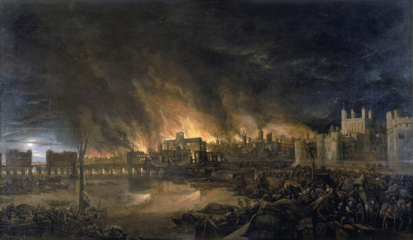
Josepha Jane Battlehooke’s ‘The Great Fire of London’ depicts the scene as though from a boat in the. vicinity of Tower Wharf. PICTURE: Public domain via Wikipedia.
Thomas Dagger, a 17th century journeyman baker, only became famous rather recently when new research identified him as the first witness to one of the seminal events in London’s history – the Great Fire of 1666.
The research was undertaken by Professor Kate Loveman at the University of Leicester for the Museum of London and will be used to inform its gallery displays when it opens its new site at Smithfield in 2026.
Drawing on letters, pamphlets, legal and guild records, Professor Loveman put Dagger, who worked in Thomas Farriner’s bakery on Pudding Lane, at the centre of the the fire’s origin story.
It’s well-known that the fire began in Farriner’s bakery in the early hours of 2nd September, 1666, and went on to consume some 13,200 homes in the city, leaving some 65,000 people homeless. But reports differ as to who was in the bakery when the fire started.
Among accounts pointing to Dagger being present is a letter from MP Sir Edward Harley who wrote in a letter to his wife that Thomas Farriner’s “man” – a term referring to his servant or journeyman – was woken after in the early hours on 2nd September choking from smoke. He reported that Farriner, his daughter and “his man” then escaped out of an upper window, but his maid died.
Dagger’s name is also found grouped with other Farriner household members among witnesses on a subsequent indictment targeting Frenchman Robert Hubert who was convicted and hanged for starting the fire after making a somewhat dubious confession.
Professor Loveman concludes that, based on her research, Thomas Dagger was the first witness to the Great Fire of London, woken by choking smoke shortly before 2am on 2nd September. Aware of the fire, he then alerted other members of the household before, along with his boss Thomas Farriner, Farriner’s son Thomas Farriner, Jr, and Farriner’s daughter Hanna, escaping by climbing out of an window. An unnamed maid who was in the house did not escape with them and was killed.
Professor Loveman’s research further showed that Dagger arrived in London from Wiltshire in 1655 and was apprenticed to one Richard Sapp for nine years but ended up serving part of that time with Farriner. Soon after the fire, in 1667, he took his freedom and by January the following year had married and had a baby. He went on to establish his own bakery at Billingsgate.
Says Professor Loveman: “It was fascinating to find out more about what happened on that famous night. Although most of the evidence about the Farriners is well known to historians, Thomas Dagger’s role has gone unrecognised. Unlike the Farriners, his name didn’t become associated with the fire at the time. Soon after the disaster, he merges back into the usual records of Restoration life, having children and setting up his own bakery. His is a story about the fire, but also about how Londoners recovered.”
John Brodie Donald, the creator of the Lost London Churches Project, talks about how the project came about, its aim and his personal favourite “lost” church…
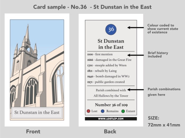
1. First up, when you talk about London’s “lost churches”, what do you mean by the expression? “Of the 108 churches in the City of London in 1600 only 39 remain. The rest have been lost in the last 350 years, either destroyed in the Great Fire of London in 1666 or in the Blitz or demolished by commercial developers as property prices soared.”
2. What is the aim of the Lost London Churches Project? “The Lost London Churches Project aims to promote interest in the ancient church buildings and parishes of the City of London through collectable cards, books, maps and downloadable explorers walks. We have created a ecclesiastical treasure hunt – a way of exploring the history of the square mile that costs nothing and can be easily fitted into a few spare lunchtimes.”
3. How many churches are included in the project? “There are 78 churches for which collectable cards have been produced and these are available in a growing number of churches in the City. It is hard to find evidence of what the churches lost in the fire of 1666 looked like, but hopefully after further research these will be included in a second edition. “
4. Does the project cover every “lost” church in the City of London? “It covers not just ‘lost’ churches but also the extant ones for two reasons. First, because those who are collecting the cards need a place to pick them up which they can do in the churches that still exist. Secondly, although the church buildings were lost, the parishes still remain to this day for administrative reasons. Every one of the 109 churches still has a parish clerk. The parishes have been amalgamated with the existing churches. So, for example, St Vedast in Foster Lane is a church of 13 united parishes having acquired them as the church buildings were lost over the centuries.”
5. Tell us how the Lost London Churches Project came about? “It all started when I was redrawing the Ogilby and Morgan map of 1676 in colour for my own pleasure. This large scale map (100 feet the inch) shows every single house in the City of 350 years ago. It was completed just after the Great Fire and so shows the location of all the lost churches clearly. The original covered 20 separate black and white sheets but I redrew them all joined together in colour on my computer. The end result was so huge it was impractical to print…So it made sense to break it up and publish in a book, and since the most interesting information in the map was the churches lost in the fire. it became the basis for the collectors book for the Lost London Churches project. At the same time, I was going through my late father’s papers and found a booklet of cigarette cards that he had collected in the 1940s. He also had a passion for painting watercolours of churches. That’s when I had the idea of producing a series of ‘cigarette cards’ showing the lost churches and the project was born.”
6. What’s the role of the cards? “The role of the cards is to give some tangible treasure to collect while exploring the lost churches. Like trading cards or Pokemon the challenge is – can you collect them all? In every participating church you will be able to pick up that church’s card along with a pack of five random cards for a small voluntary donation. Cards are also available from the project’s website lostlcp.com.”
7. You mentioned earlier that there were a number of ways the City of London’s churches become lost? “They were lost in three phases. Around 85 were destroyed or damaged in the Great Fire of 1666 of which 34 were never rebuilt. The others were rebuild by Christopher Wren, along with St Pauls Cathedral. Then 26 more churches were lost after the Union of Benefices Act of 1860 triggered a second wave of demolition. The purpose of the act was to combine parishes and free up space for the swelling capital of the British Empire. Lastly, the City suffered badly in the Blitz of World War II which took a further toll on these ancient buildings.”
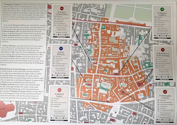
8. How easy is it to spot remnants of the City’s lost churches? “Though the buildings are lost, the parishes remain and you can still see the old parish boundary markers even on modern buildings. The best place to see an example of these is to walk down Cheapside along the New Change shopping centre towards the church of Mary le Bow. In only 100 or so yards you will have crossed the boundaries of five different parishes; St Vedast Foster Lane, St Matthew Friday Street, St Peter Westcheap, All Hallows Bread Street and St Mary Magdalene Milk Street. As you walk down the street look up above the shops ( see picture below) and you will see little plaques marking these parish boundaries. These type of parish boundary markers are scattered throughout the City. Our downloadable explorers walks on Google Maps available (for free) on our website lostlcp.com will show you some routes to find them. There is also a A4 sized map of the ancient parishes we have published for you to use as a guide.”
Parish markers on a building on Cheapside and, inset, in detail.
9. Have you uncovered any particularly interesting stories in your research into London’s lost churches? “I think one the most interesting things is the unusual names and how they were derived: Benet Fink, Stephen Coleman, Mary Somerset, Martin Ludgate and Gabriel Fenchurch. Couldn’t these be the names in an Agatha Christie mystery where the key to the murder is church themed aliases? But seriously, every church has a rich history since most were established before 1200 so in visiting them you are trekking right back to medieval times.”
10. And lastly, do you have a favourite “lost” London church? “My favourite is St Mary Abchurch just off Cannon Street. It is not only the headquarters of the ‘Friends of the City Churches’ charity but also a perfect jewel of a Wren church with the most glorious painted ceiling – like a secret Sistine chapel!”
Said to have been modelled on a rose window once inside Old St Paul’s Cathedral (which was destroyed in the Great Fire of London), the window, also known as Catherine (Katharine) Wheel, features some beautiful examples of 17th century stained glass.
The window, which is located in the chancel of the church of St Katharine Cree in Leadenhall Street in the City not far from Leadenhall Market, was installed when the church was rebuilt in the early 1630s (replacing an earlier medieval church – the church’s tower, however, dates from 1504 and was part of the earlier church on the site). It is abstract in design but
The window, which was removed to ensure its protection during World War II, has undergone repairs and the centre of the wheel was replaced after it was blown out in 1992 when a massive truck bomb went off at the nearby Baltic Exchange.
The Catherine Wheel, incidentally, was an execution device associated with the martyrdom of St Catherine of Alexandria. Catherine had upset the Emperor Maxentius in the early 4th century by speaking out against his persecution of Christians in the early fourth century. Tradition has it that after failing to break her spirit through torture (and, so say some, a marriage proposal which she refused), Maxentius ordered her to be put to death on a spiked wheel, it broke at her touch and she was later beheaded.
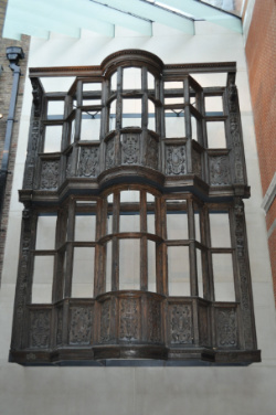
OK, so our last entry in this series isn’t a house, just a facade. But it is a significant and rare example of part of a pre-Great Fire timber-framed house in London which has been relocated.
PICTURE: tx K.B. Thommpson (licensed under CC BY 3.0)
The intricately detailed wooden facade, which can now be found in the V&A in South Kensington, was originally part of a three-and-half storey mansion which stood on the west side of Bishopsgate Without (that is, just outside the City of London’s walls).
It was built by Sir Paul Pindar, a wealthy merchant and diplomat who was knighted by King James I in 1620 (we’ll be featuring more of his story in an upcoming ‘Famous Londoners’ article).
He had purchased several properties in the street in 1597 and then incorporated these properties into a single mansion which also included a new section (of which the striking facade survives).
The house, which Shakespeare himself may well have walked past, was unusually large and sufficiently opulent that it served as the residence of Pietro Contarini, the Venetian ambassador, in 1617–18.
By 1660, it had been divided into smaller dwellings and, having survived the Great Fire of London, subsequently became a residence for the indigent. The front rooms on the ground floor, meanwhile, were turned into a tavern named the Sir Paul Pindar’s Head.
By the late 19th century, however, the nearby Liverpool Street Railway Station needed more room for expansion and, as a result, in 1890 the property was demolished to make space.
Part of the facade, however, was carefully dismantled (albeit some large sections, like the projecting carved window frames, were kept intact) and subsequently moved to the V&A where it was reassembled using carpenters’ marks on the wood.
The restored frontage (without the original glass and leading which was replaced in 1890) initially stood near the front of the museum but in the Noughties was delicately moved to where it now stands in the Medieval and Renaissance Galleries.
While the museum is currently closed as a result of coronavirus restrictions, we publish these details for when you can visit.Timed tickets can be booked for future dates here.
WHERE: Victoria and Albert Museum, Cromwell Road (nearest Tube stations are South Kensington and Gloucester Road); WHEN: Special – see above; COST: Free; WEBSITE: www.vam.ac.uk
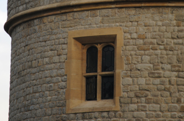
PICTURED: Not the Tower Royal, but a window from the Tower of London.
Dating possibly from as far back as the early medieval period, this royal lodging once stood in the City of London.
The building, which has been described variously as a palace as well as a strongly defended tower house, was located in the parish of St Michael Paternoster and gave its name – Tower Royall – to the street in which it was located (now long gone).
It has been suggested the property could date from as far back as the reign of King Henry I in the early 12th century and it has also been said that King Stephen is said to have lodged there later that same century (although some put the origins a bit later, possibly in the reign of King Edward I, who ruled from 1272 to 1307).
It was apparently in the possession of King Edward III in 1320 – he is said to have granted it to his wife, Queen Phillippa, who enlarged it and established her wardrobe there (hence it was sometimes referred to as the ‘Queen’s Wardrobe’).
On Queen Phillippa’s death, the king is said to have granted it to the Dean and Canons of Westminster but by 1371 it was apparently back in royal hands – Joan of Kent, the mother of the future King Richard II was living there at that time (Richard when king, apparently rode there to tell her of the suppression of the Peasant’s Revolt in 1381).
It is said to have been given to the Duke of Norfolk by his friend, King Richard III, in the 15th century, but, according to 16th century historian John Stow, by 1598 it had fallen into disrepair and was used for stabling the king’s horses.
The premises – believed to be located close to what is now Cannon Street, not far from Mansion House Tube Station – was among the buildings destroyed in the Great Fire of 1666. It was not rebuilt.
Among the buildings destroyed in the Blitz, St Stephen Coleman Street was one of the more than 50 City of London churches designed by the office of Sir Christopher Wren in the wake of the Great Fire of London of 1666.
The church was located on the corner of Coleman and Gresham Streets and replaced an earlier medieval building, the origins of which date back to at least the 13th century (the earliest mention occurs during the reign of King John) and which had also been known as St Stephen in the Jewry due to the number of Jewish people living in the vicinity.
St Stephen’s had apparently become a Puritan stronghold by the early 17th century when the vicars included John Davenport, who later went on to found a colony in Connecticut.
Five members of Parliament whom King Charles I attempted to arrest on 4th January, 1642, hid here as his troops searched for them. During the Commonwealth, the church instituted rules under which only those who were approved by a committee including the vicar and 13 parishioners – two of whom had apparently signed King Charles I’s death warrant, could receive Communion.
Following its destruction in the Great Fire of 1666, the church was rebuilt its former foundations – the new building incorporating some of the ruins of the former and featuring a bell lantern with a gilded weathervane on top – and was largely completed by 1677. In the early 1690s, additional funds gained through a coal tax provided for the construction of a burial vault and a gallery.
Notable vicars after the rebuild included Rev Josiah Pratt (1768-1844) who served for 21 years as secretary of the Church Missionary Society.
While the church suffered some minor damage during an air-raid in World War I, it was repaired. But it was finally destroyed during an air raid on 29th December, 1940, after which the church was not rebuilt but its parish joined with that of St Margaret Lothbury.
A City of London Corporation plaque at the intersection of Coleman Street and Kings Arms Yard marks the site of the former church.
PICTURE: An etching of St Stephen’s Coleman Street published in 1819.
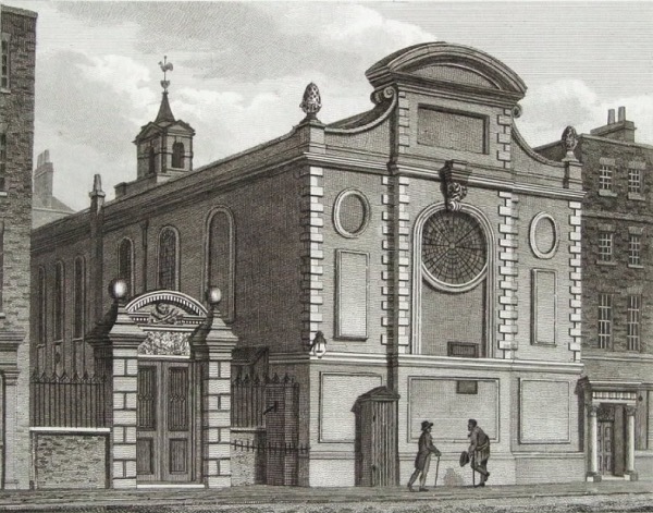
Once located on the north side of Cannon Street, St Swithin London Stone was first recorded in the 13th century, rebuilt after the Great Fire of London and finally demolished after being damaged in World War II.
The church’s curious name comes its dedication to St Swithin, a ninth century bishop of Winchester, and the London Stone, a stone of curious origins which was originally located across the road and then moved across to eventually be placed inside an alcove in the south wall of the church in the 1820s (you can read more about it here).
The medieval church was rebuilt in 1405 thanks to the largesse of Sir John Hind, twice Lord Mayor of London, and had one of the first towers built specifically for the hanging of bells.
The church was famously also the final resting place of Catrin Glyndwr, daughter of Welsh leader Owain Glyndwr, who was taken hostage in 1409 and imprisoned in the Tower of London before dying in mysterious circumstances four years later. Other notable connections include one with John Dryden who married Lady Elizabeth Howard in the church in 1663.
The church was destroyed in the Great Fire of London. Now united with St Mary Bothaw, the church was rebuilt apparently using some of the original stones, to the designs of Sir Christopher Wren. Rectangular in shape, it featured a tower in the north-west corner and an octagonal dome.
The church, which also had an association with the Worshipful Company of Salters, was heavily damaged by bombing during the Blitz. United with St Stephen Walbrook in 1954, the ruined church was eventually demolished in 1962 (the pulpit is now at All Hallows by the Tower). There’s now a garden on the site which features a memorial to Catrin Glyndwr.
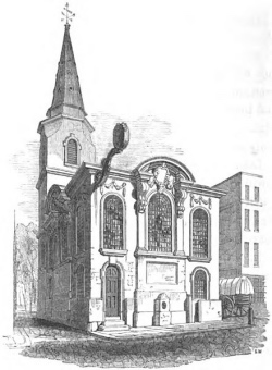
PICTURE: The Church of St Swithin, London Stone, as depicted in the 1839 book ‘The Churches of London’ by George Godwin. (public domain)
Cultural institutions across London have closed temporarily this week (or are closing soon) as part of the response to the COVID-19 virus (although it’s worth noting that at the time of writing many outdoor spaces remain open including Royal Parks and English Heritage’s outdoor spaces).
So for the time being, Exploring London will be suspending our regular Thursday ‘This Week in London’ post and be replacing it with other content. This week, we’re simply continuing with our celebratory countdown…
The Lord’s Mayor’s Show is coming up soon (10th November) so we thought it a good time to take a quick look at the life of one of the city’s most memorable Lord Mayors – Sir John Lawrence, who served in the office in 1664-65.
Sir John, a merchant and member of the Worshipful Company of Haberdashers (and Master of the company in 1677), is remembered for the role he played during the Great Plague of 1665 which preceded the Great Fire of London the following year.
Following the arrival of the plaque in London, those with the means took to their heels and left the city for safer climes. But Sir John assured the public that he and the City officers would remain at their posts to keep law and order among the frightened populace.
He oversaw the issuing of a series of plague-related orders designed to stem the spread of disease and appointed people to oversee and attend to the needs of households affected by the disease and search out the bodies to be taken away as well as doctors to tend to the sick and help prevent infection.
His efforts in ensuring the food supply remained steady have been particularly praised as has his opening of his own home in St Helen’s Bishopsgate to those servants who were discharged when the households in which they worked fled the city.
His tenure as mayor is often favourably contrasted with that of his successor, Sir Thomas Bludworth but Sir John also had numerous other positions during his lifetime, including as president of St Thomas’ Hospital, a committee member of the East India Company and a Fellow of the Royal Society.
Sir John was married and had two children. He died on 26th January, 1692, and was buried at the Church of St Helen’s Bishopsgate.
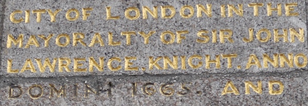
He is remembered on a plaque at Bunhill Fields for being mayor when, at the City’s expense, the burial ground was enclosed with a wall.
PICTURE: Part of the inscription at the gates of Bunhill Fields commemorating Sir John’s role in enclosing the burial ground. (Edwardx; licensed under CC BY-SA 3.0).
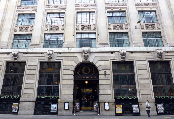
This City of London pub – a sizeable establishment to say the least, takes its name from a building that no longer exists.
Located at 9 Gracechurch Street, The Crosse Keys is located in a former purpose-built bank – that of the Hong Kong and Shanghai Banking Corporation. Designed by W Campbell Jones, the Grade II-listed building opened in 1913 and featured the largest banking floor in the City at the time.
The bank moved out in the latter part of the 20th century and JD Wetherspoon moved in, opening it as The Crosse Keys and keeping much of the original opulent interior, including marble pillars and fireplaces and a magnificent glass dome above the stairwell.
Oh, and the name? That comes from The Crosskeys Inn, a famous coaching inn which once stood on the site and took its name from the keys of heaven, held by St Peter (the crossed keys form part of the Holy See’s coat of arms).
The origins of the inn go back to before the Great Fire of London in 1666 (the inn’s yard also served as a playhouse during the Elizabethan era – the Lord Chamberlain’s Men, of which Shakespeare himself was a member, were said to be among those who performed here).
It was destroyed in the Great Fire, rebuilt and burnt down again in 1734. Rebuilt again, by the late 1800s, it had become a well known coaching inn, said to cater for some 40 or more coaches a day.
There’s a City of London blue plaque marking the site and inside, plenty of historical facts and figures in a series of prints on the walls.
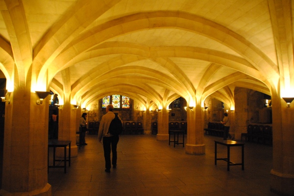
Located beneath Guildhall’s Great Hall is the oldest surviving part of the structure, the largest of London’s medieval crypts.
Dating from the reign of King Edward the Confessor in the 11th century, the vaulted East Crypt is considered to be one of the finest examples of its kind in England with a ceiling featuring a series of carved bosses depicting heads, shields and flowers.
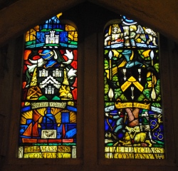
It features a series of stained glass windows depicting five famous Londoners – Geoffrey Chaucer, William Caxton, Sir Thomas More, Sir Christopher Wren and Samuel Pepys.
The pillars holding up the roof, meanwhile – once located at ground level – show signs of where horses were once tied up while their riders went about their business.
The West Crypt, which is believed to date from the 13th century, was sealed off after collapsing under the weight of the roof of the Great Hall which fell down during the Great Fire of London in 1666. It was reopened in 1973.
The windows of the West Crypt represent some of the City of London’s livery companies (pictured above, right).
One of the most famous incidents took place in the crypts on 9th July, 1851, when Queen Victoria attended a banquet here during a state visit.
The crypts today are available to hire for atmospheric events.
The name of this City of London street – which leads from Upper Thames Street to the intersection of Queen Victoria and Cannon Streets – speaks to the City’s past when it originated at the now-lost dock or jetty known as Garlickhithe.
Garlickhithe was, not surprisingly, where garlic was landed and sold in a tradition dating back to at least the 13th century. It’s one of numerous thoroughfares in the City named for what was traded there.
The name is also remembered in the church which still stands at the bottom of the hill, St James, Garlickhythe, and which once stood right on the back of the Thames. The church was founded in the 12th century, rebuilt several times – the last time after the Great Fire of London under the direction of Sir Christopher Wren.
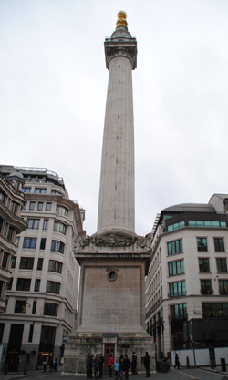
Another historic City of London view, this one dates from 1677 when construction of this memorial to the Great Fire of London was completed.
Located just a stone’s throw from the site where the fire of 1666 apparently started (more on that in our earlier post), the 61 metre high Monument was designed by Sir Christopher Wren and Dr Robert Hooke with a platform viewing platform set just below a stone drum and gilt copper urn from which flames emerge in a symbolic representation of the fire.
The viewing platform was intended as a place where Wren and Hooke could conduct experiments for the Royal Society (to this end, the Monument also features a laboratory in the cellar while its hollow shaft was designed to accommodate experiments with pendulums, its staircase steps measure exactly six inches high so they could be used in experiments on pressure and there is a trapdoor in the top of the orb to facilitate use of a telescope).
Vibrations caused by the traffic on Fish Street Hill, however, caused problems and so the idea was abandoned and the platform, located at a height of about 48.5 metres, was left to the public.
A mesh cage was added to the top in the mid 19th century, apparently as a preventative measure after a number of people had leapt from the top. The cage was replaced in 2008 as part of a major, £4.5 million, 18 month-long restoration of the Grade I-listed structure.
While people are welcome to climb the 311 steps to the top on a circular staircase that winds its way up the inside of the pillar to take in the views over the City and Thames (and about 100,000 d0 so each year, gaining themselves a special certificate for their efforts), for those who can’t make the climb, equipment enabling the streaming of live video images, taking in a 360 degree panorama from the top of the Monument, was installed as part of the restoration. These images can be accessed via the Monument’s website. The images, which take in the city, are updated every minute.
WHERE: The Monument, junction of Fish Street Hill and Monument Street (nearest Tube station is Monument); WHEN: 9.30am to 6pm daily (until October); COST: £4.50 adults/£2.30 children (aged five to 15)/£3 seniors (joint tickets with Tower Bridge available); WEBSITE: www.themonument.info
Top – Panoramic view from the top of The Monument taken in 2006; Below – The Monument. PICTURES: Top – Piotr Zarobkiewicz/Wikimedia Commons/CC BY-SA 3.0/Below – David Adams
Inside The Monument, built to commemorate the Great Fire of London, in the City of London. For more on the history of The Monument.PICTURE: Flickr/CC BY 2.0.
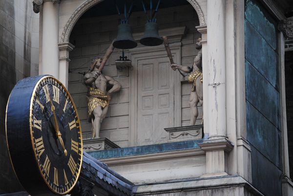
We reintroduce an old favourite this month with our first ‘Where’s London’s oldest’ in a few years. And to kick it off, we’re looking at one of London’s oldest public clocks.
Hanging off the facade of the church of St Dunstan-in-the-West in Fleet Street is a clock which is believed to have been the first public clock to be erected in London which bears a minute hand.
The work of clockmaker Thomas Harris, the clock was first installed on the medieval church in 1671 – it has been suggested it was commissioned to celebrate the church’s survival during the Great Fire of London and was installed to replace an earlier clock which had been scorched in the fire. Its design was apparently inspired by a clock which had once been on Old St Paul’s Cathedral and was destroyed in the fire.
Like the clock it replaced, this clock sat in brackets and projected out into Fleet Street which meant it was able to be seen from a fair distance away (and being double-sided meant the black dials could be seen from both the east and the west). Like the Roman numerals that decorate it, the two hands, including the famous minute hand, are gold.
To the rear and above the clock dials are located the bells and striking mechanism. The bells are struck on the hours and the quarters by ‘automata’ – Herculean figures, perhaps representing Gog and Magog (although to most they were traditionally simply known as the ‘Giants of St Dunstan’s’), who do so using clubs and turn their heads.
Such was the attention these figures attracted that when the clock was first installed the area became notorious for pick-pockets who apparently went to work on unsuspecting passersby who had stopped to watch the giants at work.
This church was demolished in the early 1800s to allow the widening of Fleet Street and when it was rebuilt in 1830, the clock was absent. Having decided it couldn’t be accommodated in the new design, it had been auctioned off with the art collector, Francis Seymour-Conway, the 3rd Marquess of Hertford, the successful bidder.
He had it installed on his Decimus Burton-designed villa in Regent’s Park and there it remained until 1935 when Lord Rothermere, who had bought the villa in 1930, returned it to the church to mark the Silver Jubilee of King George V.
There are numerous literary references to the clock including in Charles Dickens’ David Copperfield, Thomas Hughes’ Tom Brown’s Schooldays, Oliver Goldsmith’s Vicar of Wakefield and a William Cowper poem.
Located at 53 Carey Street in Holborn, this rather plain looking pub boasts a heritage apparently dating back to before the Great Fire of London.
Said to date from 1602, the Grade II-listed pub was apparently built as an alehouse, though the facade is 19th century as is much of the interior. Its location, just to the west of Temple Bar, meant it survived the Great Fire of London – though only just.
The name apparently relates to an appeal to Dutch sailors – it is said to have been so named in reference to the Seven United Provinces of The Netherlands (it’s also been said that the pub’s location is in the midst of an area of London in which Dutch settlers lived during the period).
It was apparently formerly known as The Log and Seven Stars or The Leg and Seven Stars, although it’s been speculated these are simply a corruption of The League and Seven Stars – a story which might make sense given the origins of the pub’s name (‘league’ referring to the union of the seven provinces).
The pub these days lies in the heart of the city’s legal community – the Royal Courts of Justice lies just to the south and Lincoln’s Inn, one of the four inns of court, to the north.
So we’ve come to the end of our current Wednesday series – 10 sites commemorating the Great Fire of London – to mark the Great Fire’s 350th. So here’s the recap in case you missed any:


