A former summer residence of the Archbishops of Canterbury for centuries, Croydon Palace has in more recent times been used as a school.
Dissolution
10 London bishop’s palaces, past and present – 5. Durham House…
Now long gone, this central London property was once the residence of the, you guessed it, bishops of Durham.
Subscribe for just £3 a month to access all of Exploring London’s articles…
What’s in a name?…Upminster…
Known to many as the eastern end of the District Line, Upminster is located some 16.5 miles to the north-east of Charing Cross and is part of the London Borough of Havering.
Historically a rural village in the county of Essex, its name comes from Old English and means a large church or “minster” located on high ground.
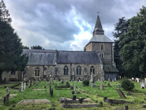
The church is said to have dated at least as far back as the 7th century and to have been one of a number founded by St Cedd, a missionary monk of Lindisfarne, in the area. It was located on the site occupied by the current church of St Laurence (parts of which date back to the 1200).
The nearby bridge over the River Ingrebourne shares the name Upminister and is known to have been in existence since the early 14th century.
Once wooded, the area was taken over for farming (cultivation dates as far back as Roman times) and by the 19th century it came to be known for market gardens as well as for some industry including windmills and a brickworks.
Development was initially centred around the minister and nearby villages of Hacton and Corbets Tey. It received a boost in the 17th century when wealthy London merchants purchased estates in the area.
Improved transportation links also helped in later centuries including the arrival of the London, Tilbury and Southend Railway in 1885 – it was extended from Barking – and the underground in 1902 via the Whitechapel and Bow Railway.
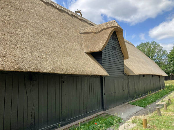
Landmarks include the Church of St Laurence, the redbrick Clock House (dating from about 1775), the 16th century house Great Tomkyns, the Grade II*-listed Upminster Windmill, built in 1803 and considered one of England’s best surviving smock mills, and the 15th century tithe barn (once owned by the monks of Waltham Abbey and now a museum).
Upminster Hall, which dates back to the 15th and 16th century (and, once the hunting seat of the abbots of Waltham Abbey, was gifted by King Henry VIII to Thomas Cromwell after the Dissolution), is now the clubhouse of the Upminister Golf Club.
Hornchurch Stadium, the home ground of AFC Hornchurch, is located in the west of the area.
It was in Upminster that local rector Rev William Derham first accurately calculated the speed of sound, employing a telescope from the tower of the Church of St Laurence to observe the flash of a distant shotgun as it was fired and then measuring the time before he heard the gunshot using a half second pendulum.
What’s in a name?…Nunhead…
This district of London, which lies to the south-east of Peckham in the London Borough of Southwark, is believed to owe its name to a local tavern named, you guessed it, the Nun’s Head on the linear Nunhead Green (there’s still a pub there, called The Old Nun’s Head, in a building dating from 1905).
There may well have been actual nuns here (from which the tavern took its name) – it’s suggested that there was a nunnery here which may have been connected to the Augustinian Priory of St John the Baptist founded in the 12th century at Holywell (in what is now Shoreditch).
A local legend gets more specific. It says that when the nunnery was dissolved during the Dissolution, the Mother Superior was executed for her opposition to King Henry VIII’s policies and her head was placed in a spike on the site near the green where the inn was built.
While the use of the name for the area goes back to at least the 16th century, the area remained something of a rural idyll until the 1840s when the Nunhead Cemetery, one of the “Magnificent Seven” cemeteries of Victorian London, was laid out and the area began to urbanise.

A fireworks manufactory – Brocks Fireworks – was built here in 1868 (evidenced by the current pub, The Pyrotechnists Arms). The railway arrived in 1871.
St Antholin’s Church was built in 1877 using funds from the sale of the City of London church, St Antholin’s, Budge Row, which was demolished in 1875. St Antholin’s in Nunhead was destroyed during the Blitz and later rebuilt and renamed St Antony’s (the building is now a Pentecostal church while the Anglican parish has been united with that of St Silas).
There’s also a Dickens connection – he rented a property known as Windsor Lodge for his long-term mistress, actress Ellen Ternan, at 31 Lindon Grove and frequently visited her there (in fact, it has even been claimed that he died at the property and his body was subsequently moved to his home at Gad’s Hill to avoid a scandal).
Nunhead became part of the Metropolitan Borough of Camberwell in 1900. These days, it’s described by Foxtons real estate agency as “a quiet suburb with pretty roads and period appeal”.
10 atmospheric ruins in London – 4. Spitalfields Charnel House…
Located under glass beneath a modern square just to the north-east of the line of the City of London’s walls are the ruins of a medieval building which once held human bones.
Built on what had originally been a Roman burial ground, the medieval hospital known as St Mary Spital was constructed towards the end of the 12th century and a graveyard was located on the site for the burial of those who died there.
A small chapel was built on the site in about 1320, the crypt of which became a charnel house housing the bones of those remains disturbed when
The hospital, which had been run by Austin canons, was dissolved by King Henry VIII in 1539 and most of the bones removed. The crypt was later used as a house which was demolished around 1700 and later lost between the gardens of terraced houses.
The remains of the charnel house was discovered in the late 1990s during excavation works – complete with some 10,000 skeletons – and now lies under a glass floor in Bishop’s Square just to the west of Spitalfields Market (it can also be seen through a glass window in the basement level accessed via stairs in the square).
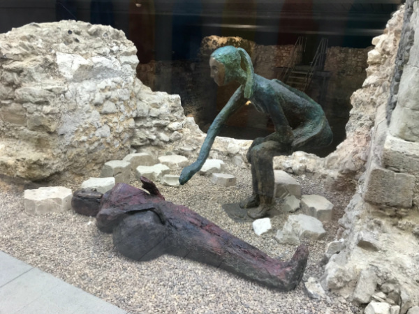
Two statues can be seen inside the ruins – a greenish figure crouching over a prone purple-red figure. Installed in 2014, they are the work of David Teager-Portman and are called Choosing the Losing Side and The Last Explorer.
Spitalfields Chapel and Charnel House, Bishops Square, London, Spitalfields (nearest Tube station is Liverpool Street; nearest Overground is Liverpool Street and Shoreditch High Street).
10 atmospheric ruins in London – 1. The Church of St Alphege London Wall…
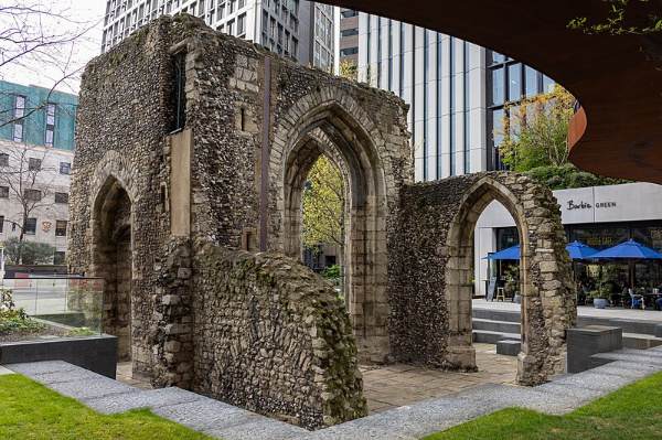
The ruins of this church – which now sit in a public garden – are actually the remains of the second church in the vicinity.
Dedicated to the murdered Archbishop of Canterbury (there’s a similarly named church in Greenwich), the first St Alphege (also known as St Alphege London Wall and St Alphege Cripplegate) dated from at least the 11th century but was closed and demolished during the Dissolution (the other part of its name comes from its location abutting London Wall).
The second church started life as the priory church of the nunnery of St Mary-within-Cripplegate which later became a hospital before it too was closed in the Dissolution.
The church, however, became the parish church and, subsequently repaired, it survived the Great Fire of 1666. Further repairs followed and a more comprehensive rebuilding in the 18th century (with the medieval tower retained).
But by 1900, parts of the church were in a poor state and after the church was damaged during an air raid in World War I, the parish was amalgamated with St Mary Aldermanbury (the combined parish was later united with St Giles Cripplegate) and it was eventually mostly demolished in the early 1920s.
The medieval tower remained but was gutted by fire in 1940. Its ruins were subsequently surrounded by a small public garden. Further restoration work was done as part of works to install a raised walkway in 2018-19.
The remains of the church – which include the tower and arches on three sides – are Grade II-listed and while it’s surrounded these days by modern office buildings, it remains a small piece of a bygone era.
The gardens are free to visit.
What’s in a name?…Carmelite Street (and Whitefriars Street)…

These two City of London thoroughfares – which run from Fleet Street down to Victoria Embankment (connected at Tudor Street) – both owe their name to the same institution.
A friary run by the Carmelites – also known as the “White Friars” because of the white mantle they wore over their brown habits – was established here in 1253 and enlarged until eventually it stretched all the way from Fleet Street down to the Thames.
The monastery was dissolved in the Dissolution and the buildings repurposed with the great hall becoming a playhouse.
The street marks the eastern boundary of the friary (then known as Water Lane).
A remnant of the monastery can be seen down Magpie Alley (see the post for more on the history of the priory).
Lost London – Arundel House…
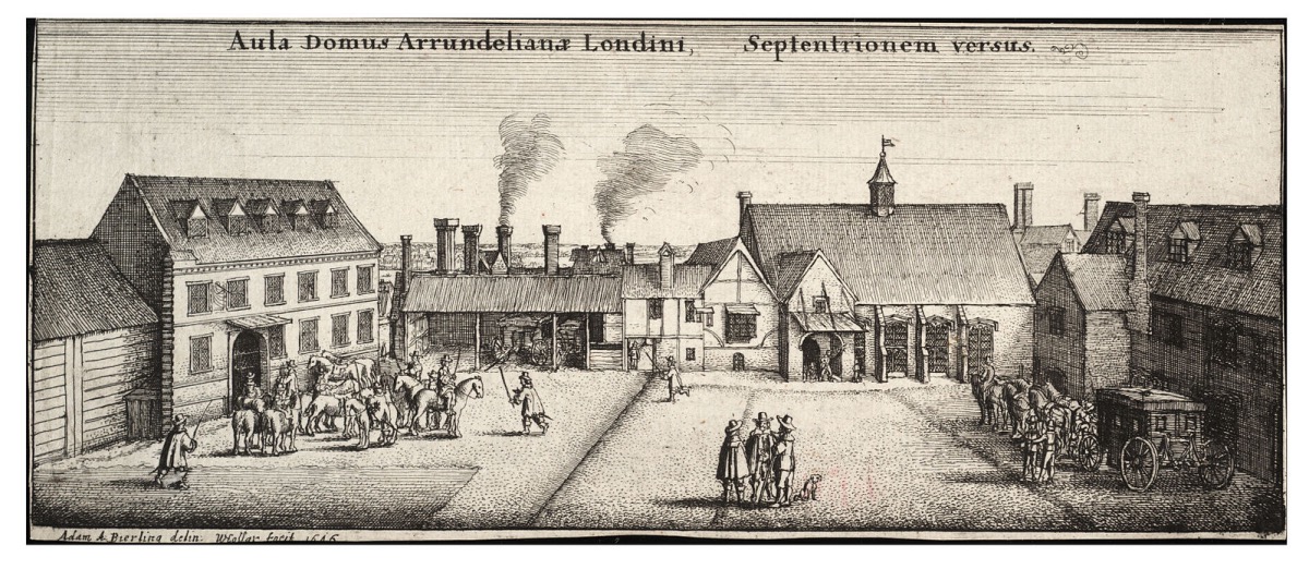
One of a string of massive residences built along the Strand during the Middle Ages, Arundel House was previously the London townhouse of the Bishops of Bath and Wells (it was then known as ‘Bath Inn’ and Cardinal Thomas Wolsey was among those who resided here during this period).
Following the Dissolution, in 1539 King Henry VIII granted the property to William Fitzwilliam, Earl of Southampton (it was then known as Hampton Place). After reverting to the Crown on his death on 1542, it was subsequently given to Thomas Seymour, 1st Baron Seymour of Sudeley, a younger brother of Queen Jane Seymour, Henry VIII’s third wife, and known as ‘Seymour Place’. Then Princess Elizabeth (late Queen Elizabeth I) stayed at the property during this period (in fact, it’s said her alleged affair with Thomas Seymour took place here).
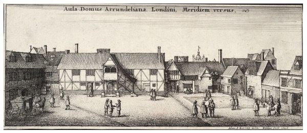
Seymour significantly remodelled the property, before in 1549, he was executed for treason. The house was subsequently sold to Henry Fitz Alan, 12th Earl of Arundel, for slightly more than £40. He was succeeded by his grandson, Philip Howard, but he was tried for treason and died in the Tower of London in 1595. In 1603, the house was granted to Charles, Earl of Nottingham, but his possession was short-lived.
Just four years later it was repurchased by the Howard family – in particular Philip’s son, Thomas Howard, 14th Earl of Arundel – who had been restored to the earldom.
Howard, who was also the 4th Earl of Surrey, housed his famous collection of sculptures, known as the ‘Arundel Marbles’, here (much of his collection, described as England’s first great art collection, is now in Oxford’s Ashmolean Museum).
During this period, guests included Inigo Jones (who designed a number of updates to the property) and artist Wenceslas Hollar who resided in an apartment (in fact, it’s believed he drew his famous view of London, published in 1647, while on the roof).
Howard, known as the “Collector Earl”, died in Italy in 1646. Following his death, the property was used as a garrison and later, during the Commonwealth, used as a place to receive important guests
It was restored to Thomas’ grandson, Henry Howard, 6th Duke of Norfolk, following the Restoration. Following the Great Fire of London in 1666, for several years the property was used as the location for Royal Society meetings.
The house was demolished in the 1678. It’s commemorated today by the streets named Surrey, Howard, Norfolk and Arundel (and a late 19th century property on the corner of Arundel Street and Temple Place now bears its name).
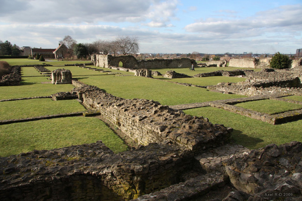
Lost London – Lesnes Abbey…
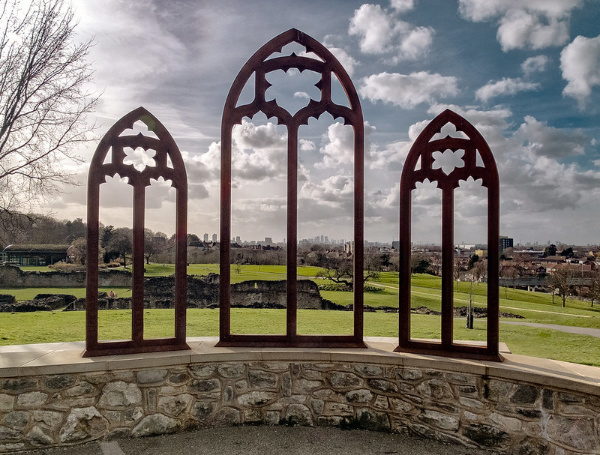
Located in London’s south-east, Lesnes Abbey was founded in 1178 as the Abbey of St Mary and St Thomas the Martyr by Richard de Luci, a joint Chief Justiciar of England at the time.
It’s believed de Luci did so as an act of penance for his support of King Henry II in his dispute with St Thomas Becket (in fact, de Luci was ex-communicated by him twice before Becket was murdered in Canterbury Cathedral in December, 1170). De Luci retired here after resigning his office in 1179 and died soon after. He was buried in the chapter house.
The Augustinian monastery, never a large or wealthy community, had fallen into a state of disrepair and debt by the early 15th century apparently due to mismanagement but at least partly caused by the cost of maintaining the river wall and draining the marshes in which it was located.
Some rebuilding was carried out at the start of the 16th century but in 1525 it was closed or suppressed on Cardinal Thomas Wolsey’s orders and the monastic buildings were demolished with the exception of the Abbot’s lodging.
The site was subsequently sold off and passed through various hands – it spent some 300 years as a possession of Christ’s Hospital – and eventually became farmland with the abbot’s house forming the core of a farmhouse which was demolished in 1844.
The site was excavated under the direction of Sir Alfred Clapham in the early 20th century and was purchased by the London County Council in 1930. It was opened as a public park in 1931. Since 1986, it’s been owned and managed by the London Borough of Bexley.
The site today, a scheduled ancient monument, includes some impressive ruins from the abbey. The nearby woods takes its name from the abbey.
10 (lesser known) National Trust properties in London…2. Morden Hall Park…
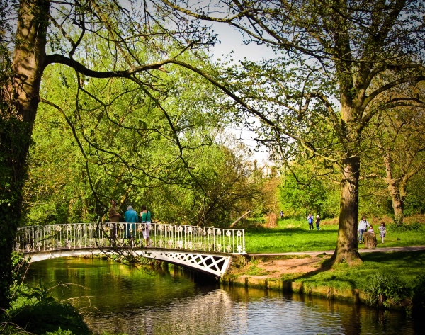
Located on the banks of the River Wandle in Morden, south London, Morden Hall was built for the Garth family in the 18th century on the site of an earlier manor house.
The manor, which had once been held by the abbot of Westminster Abbey, had been in the Garth family since it was purchased by Richard Garth, a clerk and son of a successful lawyer, following the Dissolution in the 16th century. At the time, the newly built manor house, apparently known as Growtes, stood just to the south of where the hall now stands.
 The now Grade II-listed hall was built for the family in between 1759 and 1765 and over the next century a number of tenants occupied it – it was used at once point as a school for young gentlemen.
In 1867, the Garth family sold the altered house and estate to a tobacco merchant, Gilliat Hatfeild (Gilliat’s father, Alexander Hatfeild, had, since 1834, leased two mills on the site to ground tobacco from plantations in Virginia into snuff). Gilliat created a park from the land surrounding the hall, planting trees and demolishing cottages.
His son, Gilliat Edward Hatfeild, took over the running of the estate on the death of his father in 1906. During World War I, the hall saw service as a convalescent home for the military and was later used by the Salvation as a home for women and children.
In 1941, Alexander’s grandson, Gilliat Edward Hatfield – who had closed the mills and snuff-making factory in the early 1920s – left the house and the core of the estate (the remainder was occupied by new housing and roads) to the National Trust. The hall itself has since been used as a restaurant and, following a 2015 renovation, is now a venue for weddings.
The 125 acres of grounds, which are open to the public, contain a variety of landscapes including the remains of a deer park, meadows and a wetland. The restored rose garden was first planted by Gilliat Edward Hatfeild in around 1921 in part of what had been his father’s deer park. It was laid out in two halves separated by a small stream with rose-covered bridges. The rose garden also features a massive Westfelton Yew which is believed to be hundreds of years old.
The snuff mills, which were built in 1750 and 1830, are still standing (the western mill contains an exhibition on the life of the Morden mill workers in the Victorian era) as are various workshops, the former stables and Morden Cottage, parts of which date from the 1750s and which was used by GE Hatfeild who preferred living there to the hall. Facilities in the park include the Potting Shed Café near the main entrance and a second-hand bookshop in the former stable yard.
WHERE: Morden Hall Park, Morden Hall Road, Morden (nearest train station is Stableyard); WHEN: The rose garden is open from 8am to 6pm daily (check the website for other times); COST: Free; WEBSITE: www.nationaltrust.org.uk/morden-hall-park.
PICTURES: Top – The White Bridge over the River Wandle at Modern Hall Park (Garry Knight/licensed under CC BY 2.0); Right – Morden Hall from the park (public domain)
Lost London – Merton Priory…
Little remains of this priory which once stood on the banks of the River Wandle in Surrey (and is now encompassed in Greater London).
The priory, which was founded as an Augustinian house in the early 12th century, rose to become one of the most influential in all of southern Britain.
 The institution was created thanks to Gilbert, the Sheriff of Surrey, Huntington and Cambridge, who was granted the village of Merton by King Henry I. Gilbert came to live in Merton and there established a priory, building a church and small huts on land thought to be located just to the west of where the priory was later located.
Gilbert had been impressed with what he’d seen of the Augustinians, also known as the Austin friars, at Huntington and so gave control of the new church to their sub-prior, Robert Bayle, along with the land and a mill.
It was based on Bayle’s advice that the site of the priory was then moved to its second location and a new, larger wooden chapel built with William Gifford, Bishop of Winchester, coming to bless the cemetery. The canons – there were now 17 – moved in on 3rd May, 1117.
Among the high profile people to visit the new priory was Queen Matilda, who brought her son William with her. In the early 1100s, a certain Thomas Becket (later the ill-fated Archbishop of Canterbury) received an education here as did Nicolas Breakspeare (later the first English Pope, Adrian IV).
The priory expanded considerably over the next century and in 1217 its chapter house was the location of a peace conference between King Henry III and Louis, the Dauphin of France. The Statutes of Merton – a series of legal codes relating to wills – were formulated here in 1236.
The connection with royalty continued – in the mid-1340s, King Edward III is thought to have passed the Feast of the Epiphany here while King Henry VI apparently had a crowning ceremony here – the first outside of Westminster Abbey for more than 300 years – in 1437.
The priory remained in use until the Dissolution of King Henry VIII. The demolition of the buildings apparently started even before the priory had been formally surrendered to the commissioners – stones from its building was used in the construction of Henry’s new palace – Nonsuch – as well as, later, in the construction of local buildings.
The site came to be referred to as ‘Merton Abbey’ and, passing through various hands, was used to garrison Parliamentarian troops during the Civil War. It later became a manufacturing facility, works for the dying and printing of textiles, one of which became the workshops of William Morris.
Some of the priory buildings survived for some years after but the only remains now left as sections of the perimeter wall (the arch which now stands over the entrance to Merton parish church is reconstructed – there’s another ornamental gateway in the outer court wall which was also replaced with a replica in the 1980s).
The foundations of the unusually large chapter house, meanwhile, have been excavated and are now preserved in a specially constructed enclosure under a roadway. Construction is now underway to build better public access to the remains.
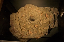
PICTURE: A ceiling boss from Merton Priory which still bears traces of its original red paint and guilding. It was found during excavations at Nonsuch Palace in 1959-60 is now on display in the Museum of London. Photograph by Mike Peel (www.mikepeel.net) (licensed under CC-BY-SA-4.0).
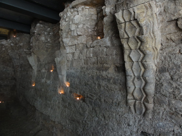
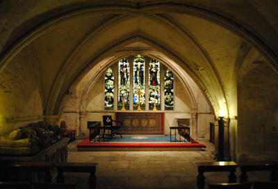
10 subterranean sites in London – 8. Priory of St John of Jerusalem church crypt…
More correctly known as the crypt of the Priory of the Order of St John of Jerusalem, this subterranean chamber dates from the 12th century and is the oldest surviving part of what remains of the priory.
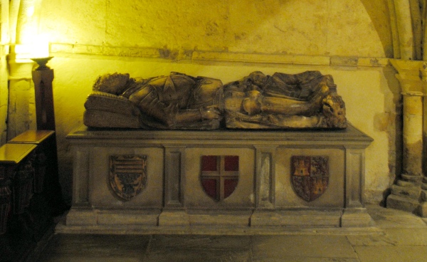
Based close to St John’s Gate in Clerkenwell – another surviving section of the monastery, the partly Romanesque crypt features some magnificent 16th century monuments including the rather skeletal-looking funeral effigy of the last prior, Sir William Weston, who apparently died on the very day the priory was dissolved in May, 1540 (he apparently collapsed on hearing the news).
The crypt also contains a 16th century tomb effigy (pictured below) believed to be that of Don Juan Ruiz de Vergara, a Castilian Knight Hospitaller who died fighting the Turks at sea off the coast of Marseilles (it had apparently formerly been located in Valladolid Cathedral in Spain and was donated by a member of the order (and first Keeper of the London Museum, now known as the Museum of London), Sir Guy Francis Laking, in 1915). Understood to have been the work of Esteban Jordan, sculptor to King Philip II of Spain, the knight bears the eight pointed star of the order on his breastplate.
Meanwhile, the stained glass in the crypt chapel’s east lights depict the entombment of Christ as well as Raymond du Puy (Grand Master of the Order of St John from 1118–60), St John the Baptist and St Ubaldesca. Other stained glass windows in the chapel depict saints like St George, Andrew, Patrick and David and some of the English branch’s priors and knights.
Other items of interest in the crypt include a 13th century font, originally from a church in Buckinghamshire, and a stone fragment from the pavement of the Grotto of the Nativity at Bethlehem.
The priory once served as the English headquarters for Order of St John of Jerusalem, also known as the Knights Hospitaller. The order was founded in Jerusalem in 1080 to care for the sick and poor, and spread across Europe. The English ‘branch’ established on 10 acres just outside the City walls apparently by a knight, Jorden de Briset. It was dissolved, as we’ve already heard, in 1540.
WHERE: Crypt, St John’s Church, St John’s Lane, Clerkenwell (nearest Tube stations is Farringdon); WHEN: The crypt can only be visited on tours – public tours are held at 11am and 2.30pm on Tuesday, Friday and Saturday; COST: Free (a suggested £5 donation); WEBSITE: www.museumstjohn.org.uk.
10 subterranean sites in London – 5. Whitefriars Priory crypt…
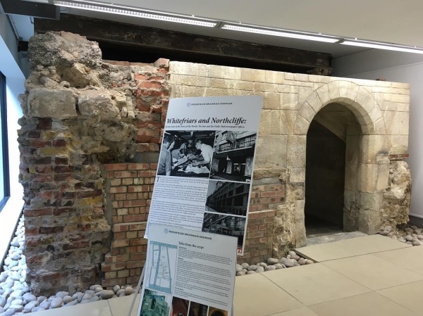
Located in the basement of a modern office building (and visible through glass) are the remains of a 700-year-old crypt that once lay beneath Whitefriars Priory.
Reached via Magpie Alley (off Bouverie Street which runs south from Fleet Street), the remains are all that is visibly left of the priory, founded here in the 13th century.
Known as ‘White Friars’ because of the white mantle they wore over their brown habits, the Carmelites (their proper name) were founded in what is now Israel in the mid-12th century. After the region fell to the Saracens in the mid-13th century, some members of the order made their way to England with the aid of Richard, Earl of Cornwall, brother of King Henry III. In 1241, Sir Richard Grey of Codnor founded the Priory of Our Lady of Mount Carmel on this site.
The priory – which counted towering medieval figure John of Gaunt among its patrons – once stretched from Fleet Street to the Thames and to the Temple in the west and what is now Whitefriars Street in the east. It included a church – enlarged in the 14th century – as well as cloisters, a garden and cemetery.
The priory survived until the Dissolution after which King Henry VIII granted various buildings to the King’s Physician and the King’s Armourer and the great hall become the famous Whitefriars Playhouse.
Whitefriars became part of the rather infamous slum known as Alsatia, a ‘liberty’ seen as a place of sanctuary for those fleeing the law. The priory was gradually subsumed into the slum – there’s a suggestion that the crypt may have been used as a coal cellar.
The remains of the 14th century vaulted crypt, which had been located beneath the prior’s house on the east side of the former priory site, were apparently found in the late 19th century and restored in the 1920s when the now defunct newspaper News of the World was expanding. During a redevelopment in the 1980s (which came after News International moved out to Wapping), the remains were moved to their current location.
WHERE: Whitefriars Crypt, Ashentree Court, City of London (nearest Tube stations are Temple and Blackfriars); WHEN: Daily; COST: Free; WEBSITE: None.
PICTURE: The crypt at seen at this year’s Open House London event. (Andrea Vail licensed under CC BY-ND 2.0.)
Lost London – The Nunnery of St Mary, Clerkenwell…
 The Church of St James, which stands just to the north of Clerkenwell Green, is all that remains today of the medieval nunnery which once occupied a large swathe of land in the area.
The Augustinian Nunnery of St Mary was founded in about 114o by Jorden de Briset, the lord of Clerkenwell Manor (he also founded the Hospitaller Priory of St John of Jerusalem which lay to the south – more on this here) on 14 acres of land to the east of the famous “Clerk’s Well” (more on the well, which was located close to, but within, the western border of the nunnery, in our earlier post here).
By 1160 a wall had been built around the precinct said to have been roughly bounded by Farringdon Lane, Clerkenwell Green (an open space between the two religious houses), St James’s Walk and a boundary to the south of, and parallel with, Bowling Green Lane to the north.
The church – where Briset and his wife were later buried and which doubled as a parish church – was built about the same time, along with an adjoining chapter-house – both of which were made of stone in contrast to the timber buildings which initially made up the rest of the complex.
A cloister and other stone buildings were erected to the north of the church later in the 12th and 13th centuries including a lodging for the prioress, a dormitory, refectory and kitchen for the nuns. Other buildings on the site included a gatehouse, what was known as the “Nun’s Hall” – possibly a hall for guests – and an infirmary with its own chapel, the location of which is apparently something of a mystery.
Substantial renovation works were carried out in the late 15th and early 16th centuries and by the time of King Henry VIII’s dissolution, it had become one of the wealthiest monasteries in England (although it only ever housed about 20 canonesses).
One of the last nunneries to be suppressed, it was dissolved in 1539 with the nuns being pensioned off.
The site was initially granted to Thomas Howard, 3rd Duke of Norfolk, who held it only briefly being returning it to the king in a deal for another property and subsequently purchased by a succession of different owners.
Many of the buildings were converted for use as private mansions and outbuildings, among them Newcastle House and Challoner (later Cromwell due to the legend that Oliver Cromwell resided there) House which faced them across what had been the cloister courtyard.
The mansions were gradually redeveloped into smaller properties – it remained a popular residential area despite the building of a House of Detention to the immediate north – and in 1788-92, the parish church of St James was rebuilt to the designs of local architect James Carr, with the spire apparently modelled on St Martin-in-the-Fields (Carr also bought Newcastle House and pulled most of it down before redeveloping the area).
Church gardens, which are open to the public, now occupy some of the site of the former nunnery – in 1987, part of the medieval cloisters were excavated here.
For some insightful walks delving into the history of London, see Stephen Millar’s three books, London’s Hidden Walks: Volumes 1-3.
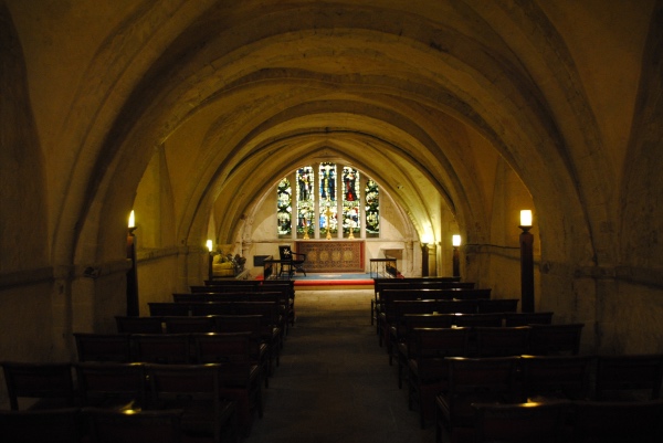
Lost London – Chapel of St Thomas á Becket…
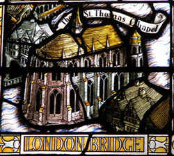
Known informally as the Chapel on the Bridge, the Chapel of St Thomas á Becket was located in the middle of London Bridge and, as the name suggests, was dedicated to the ill-fated archbishop of Canterbury.
 Founded in 1205, the stone chapel was among the first buildings constructed on the bridge by priest-architect Peter de Colechurch in 1176, who was actually buried beneath the chapel (for more on him and the construction of the bridge, see our earlier posts here and here).
Facing downstream and located on a wider than normal pier – the 11th pier from the Southwark end of the bridge and the ninth from the City end – the original chapel was built in the early English Gothic style and consisted of an upper chapel with a groined roof and columns and vaulted lower chapel or undercroft. Standing some 40 foot high, it would have towered over the shops and residences on the bridge. There is some suggestion it was damaged by fire in 1212 and may have had to have been extensively repaired.
It’s name ensured its popularity – Becket was martyred in Canterbury Cathedral in 1170, apparently on the orders of King Henry II, and, canonised just three years later, had quickly become the focus of a popular religious cult in his home town of London. The chapel also became renowned as a wayside stop for pilgrims to receive the saint’s blessing before making their way to Canterbury where his shrine was located.
But it wasn’t just pilgrims who had an attachment – the chapel was apparently popular among watermen who, when the tide allowed them, were known to tie up their craft on the chapel pier and ascend to the undercroft through a lower entrance.
The chapel – which apparently had two priests at the beginning as well as a number of clerks although the number of priests is known to have climbed as high as five in the 14th century – was nominally under the control of the priest of the church of St Magnus-the-Martyr, located at the City end of the bridge. The reality seems to have been however, that the priests and other “Brothers of the Bridge” enjoyed considerable freedom in their roles, including, after 1483, obtaining the right keep alms taken during services provided he made a generous contribution to the parish finances. Like most who worked on the bridge, the priests and “clerks of the chapel” would likely have lived on it.
Relics housed in the chapel apparently included fragments of the True Cross and a number of chantries were built inside the chapel in the 14th century – it’s believed this may have led to some overcrowding and been one of the reasons for a major rebuilding of the chapel – this time in the Perpendicular Gothic style – between 1384 and 1397.
The chapel survived until the Dissolution when, in 1548, the priest was ordered to close it up and it was desecrated and later converted into a dwelling (later still, parts of it were used as a warehouse). It was demolished over succeeding years – by the late 18th century just the lower chapel remained – with the final remnants removed in the early 1800s.
Some bones in a small casket were disinterred in from the chapel undercroft during this process in the early 19th century. Although these were rumoured to be those of de Colechurch, analysis found them to be part of a human arm bone, a cow bone and goose bones. (Other accounts suggest most of Peter’s bones were tossed into the Thames and that a small number were even sold at auction).
There’s a stained glass window commemorating the bridge in St Magnus-the-Martyr Church today (pictured above).
10 sites from London at the time of the Magna Carta – 10. Priory of the Order of St John of Jerusalem…
Founded in Clerkenwell in 1144, the Priory of the Order of St John of Jerusalem served as the order’s English headquarters.
The order, also known as the Knights Hospitaller, was founded in Jerusalem in 1080 to care for the sick and poor, and soon spread across Europe with the English ‘branch’ established on 10 acres just outside the City walls apparently by a knight, Jorden de Briset.
The original buildings – of which only the 12th century crypt (pictured above) survives complete with some splendid 16th century tomb effigies including that of the last prior, Sir William Weston – included a circular church, consecrated in 1185, and monastic structures including cloisters, a hospital, living quarters and a refectory or dining hall.
There are records of dignitaries staying at the priory as it grew in size and renown – among them was King John who in 1212, apparently stayed here for an entire month. There are also surviving accounts of Knights Hospitaller riding out in procession from the priory and through the City at the start of a journey to the Holy Land.
The priory and church were attacked during the Peasant’s Revolt of 1381, thanks to its connection with the hated Poll Tax (Prior Robert Hales was also the Lord High Treasurer and was beheaded during the revolt on Tower Hill).
The church was subsequently rebuilt as a rectangular-shaped building and then, in the early 16th century, enlarged when the site was significantly renovated. These renovations were still relatively new when the priory was dissolved in 1540 during the Dissolution of King Henry VIII.
The priory church, which survived the Great Fire of 1666, was later used as a parish church but was destroyed in an air raid in World War II. Subsequently rebuilt, it can be visited today along with the crypt below and the cloister garden, created in the 1950s as a memorial to St John’s Ambulance members from the London area (the original shape of the circular church is picked out in the paving here).
Perhaps the most famous building to survive is St John’s Gate which dates from the 16th century and was once the gatehouse entrance to the priory (added in the final renovations).
After the Dissolution it served various roles including as the office of the Master of Revels (where Shakespeare’s plays were licensed), the home of The Gentleman’s Magazine (Samuel Johnson was among contributors and worked on site), a coffee house (run by William Hogarth’s father) and a public house called the Old Jerusalem Tavern (yes, Charles Dickens was said to be a regular). It is now home to the recently renovated Museum of the Order of St John (you can see our earlier post on the museum here).
WHERE: Museum of the Order of St John, St John’s Gate (and nearby priory church), St John’s Lane, Clerkenwell (nearest Tube stations is Farringdon); WHEN: 10am to 5pm, Monday to Saturday (tours are held at 11am and 2.30pm on Tuesday, Friday and Saturday); COST: Free (a suggested £5 donation for guided tours); WEBSITE: www.museumstjohn.org.uk.
We’ll kick off a new Wednesday series next week…
10 sites from London at the time of the Magna Carta – 8. Bermondsey Abbey…
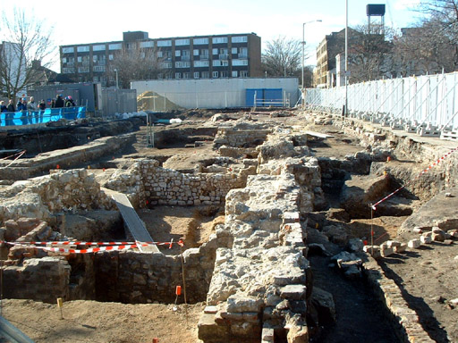 Bermondsey Abbey, which was more than 130-years-old by the time King John put his seal to the Magna Carta in 1215, has an unusual connection to the unpopular king – it is one of a number of buildings in London which has, at various times in history, been erroneously referred to as King John’s Palace.
This suggestion – that it was a palace which was later converted into an abbey – may have arisen from a site on the former abbey grounds being known at some point in its history as King John’s Court (that name was said to commemorate the fact that King John visited the abbey).
Putting how King John’s name came to be linked with the abbey aside, we’ll take a quick look at the history of the abbey which rose to become an important ecclesiastical institution in medieval times.
While there was a monastic institution in Bermondsey as far back as the early 8th century, the priory which was here during the reign of King John was founded in 1082, possibly on the site of the earlier institution, by a Londoner named as Aylwin Child(e), apparently a wealthy Saxon merchant who was granted the land by King William the Conqueror.
In 1089, the monastery – located about a mile back from the river between Southwark and Rotherhithe – became the Cluniac Priory of St Saviour, an order centred on the French abbey of Cluny, and was endowed by King William II (William Rufus) with the manor of Bermondsey.
It was “naturalised” – that is, became English – by the first English prior, Richard Dunton, in 1380, who paid a substantial fine for the process. It was elevated to the status of an abbey by Pope Boniface IX in 1399.
It had some important royal connections – King John’s father, King Henry II and his wife Queen Eleanor celebrated Christmas here in 1154 (their second child, the ill-fated Henry, the young King, was born here a couple of months later), and Queen Catherine (of Valois), wife of King Henry V, died here in 1437. It was also at Bermondsey Abbey that Elizabeth Woodville, the widow of King Edward IV and mother of the two “Princes in the Tower”, died in 1492 following her retirement from court.
The abbey, which grew to have an enormous income thanks to its acquisition of property in a range of counties, survived until the Dissolution when, in 1537, King Henry VIII closed its doors. It was later acquired by Sir Thomas Pope who demolished the abbey and built a mansion for himself on the site (and founded Trinity College in Oxford apparently using revenues from the property). We’ll deal more with its later history in an upcoming post.
The ruins of the abbey were extensively excavated in the past few decades and some of the remaining ruins of the abbey can still be seen buildings around Bermondsey Square and a blue plaque commemorating the abbey was unveiled in 2010. Bermondsey Street runs roughly along the line of the path which once led from the abbey gates to the Thames and the abbey had a dock there still commemorated as St Saviour’s Dock. The abbey’s name is commemorated in various streets around the area.
For more on the history of the Magna Carta, see David Starkey’s Magna Carta: The True Story Behind the Charter.
PICTURE: An archaeological dig at the ruins of Bermondsey Abbey in 2006. Zefrog/Wikipedia.
10 sites from London at the time of the Magna Carta – 2. St Bartholomew the Great…
St Bartholomew the Great in Smithfield – the oldest parish church in London (see our earlier piece here) – is worth a revisit thanks to the fact that it would have been standing (at least partially) when the seal of King John was first affixed to the Magna Carta .
 Only half the size it once was, this church was founded in 1123 AD as the priory church for a community of Augustinian Canons and owes its origins to Rahere, a favored courtier of King Henry I who renounced his way of life and made a pilgrimage to Rome, returning to found both the church and nearby hospital for the poor.
Only the eastern part of the church was built by the time of the death of Rahere – the first prior – in 1145 and the building continued for some years afterward. While the interior walls now look somewhat plain, they would have been highly decorated when the building was originally constructed. At the time of the Magna Carta, the church would have only been partly completed.
The tomb of Rahere still lies within the church, on the left hand side of the altar – although the canopy over it dates from the 15th century. There were some healing miracles recorded at the tomb.
The church’s current configuration came about when the priory was dissolved in 1539 and the nave of the church was pulled down, leaving what’s there now – the quire, altar and lady chapel.
The brick tower at the church’s west end dates from the 1620s while the gateway through which you enter the church grounds features a restored 13th century arch topped by a late Tudor building.
The church was briefly used by some Dominican friars but since the reign of Queen Elizabeth I has fulfilled the role of parish church. A concerted restoration effort began in the mid-19th century by Sir Aston Webb (architect of the Victoria & Albert Museum), leaving the Lady Chapel with a very different feel to the Norman choir. The building is now Grade I-listed.
WHERE: Off Little Britain, West Smithfield (nearest tube station is Barbican); WHEN: 8.30am to 5pm Monday to Friday, 10.30am to 4pm Saturday, 8.30am to 8pm Sunday (except for services) ; COST: £4 an adult/£3.50 concession/£10 a family; WEBSITE: www.greatstbarts.com
Lost London – The Blackfriars Playhouse…
Located on the site of the former Blackfriars Monastery which has closed during the Dissolution (see our earlier post here), the origins of the Blackfriars Playhouse or Theatre go back to the mid-1570s when children connected with the Queen’s Chapel Choir performed plays in part of the former monastery.
While those plays were performed in order to practice for those performed before Queen Elizabeth I, the organisers did also apparently use the theatre for paying audiences. This first theatre ceased operation in 1584.
In 1596, part of the priory and an adjoining building were bought by James Burbage in 1596 who created a playhouse within them. It was used by the Children of the Chapel, a group of choristers and other boys, until 1608 when the King’s Men took over – with Burbage’s son Richard and Shakespeare among those who had a share in the theatre – and used it as their winter playhouse.
The theatre – where Shakespeare himself is believed to have performed – was apparently the first commercial premises of its type to used artificial lighting and, usually for the time, featured music between acts.
The wife of King Charles I, Queen Henrietta Maria, is known to have attended the theatre later in its life in 1634 and again a couple of years later.
The theatre closed with the commencement of the English Civil War and the theatre was demolished in 1655.
The candle-lit Sam Wanamaker Playhouse, which opened in January at the Globe Theatre on Bankside, was designed based on drawings of indoor theatres of the era (there’s also a recreation of the Blackfriars Playhouse in the US which is home to the acting troupe of the American Shakespeare Center).
While nothing remains of the playhouse today, it lives on in the name Playhouse Yard.
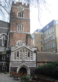
London Pub Signs – The Minories…
 Located close to Tower Hill in the eastern part of the City, this pub – and indeed the street in which it sits (at number 64-73) – takes its name from a former nunnery that was once located here.
Known as the Minoresses, the nuns – who belonged to the Order of St Clare (also known as the Poor Clares) – lived in a nunnery here. The institution was founded by in 1293 by Edmund, the brother to King Edward I (reigned 1272-1307), and the earl of Lancaster, Leicester, and Derby, to house nuns who had been brought to England from Spain by the earl’s wife, Blanche of Artois, the widow of King Henry I of Navarre.
As with the case of the Black Friars, the name came to be used to refer to the district in which the now long-gone nunnery once stood (it was dissolved in the Great Dissolution and later used as a residence by the likes of Henry, Duke of Suffolk and father of Lady Jane Grey) and lives on in the name of the street and the pub.
The pub, which has undergone a paint job since our picture was taken, is located under a railway bridge (and may have once been part of the former Minories Railway Station which closed in 1873. For more, see www.minories-london.co.uk.
