Lost London – Blackwell Hall…

A trade hall for the wool and cloth trade, Blackwell Hall, also known as Bakewell Hall, once stood on the east side of Guildhall Yard in Basinghall Street.

The buttressed stone building – whose previous owners included Thomas Bakewell (from where apparently it gets its name) – is understood to have been purchased by the City of London Corporation during the reign of King Richard II and subsequently established as a cloth market.

‘Factors’ were introduced to act as agents and handle the sale of goods on behalf of the clothiers but shifts in trade – in particular the expansion of northern mills which led to them handling their sales directly –  saw the importance of the London-based factors wane.

The structure was rebuilt a couple of times over its lifespan – there are records of a rebuilding in 1588 and again after the Great Fire of 1666 – before it was finally demolished in 1820 to make way for the Bankrupcy Court.

Remains of the foundations were discovered during excavations in Guildhall Yard in 1988.

Lost London – The London Colosseum…

Designed by architect Decimus Burton (he of the Kew Palm House fame), the London Colosseum was a vast, 16-sided domed structure erected in the 1820s to the east of Regent’s Park to house a panoramic view of the city.

ColosseumSaid to be the largest ever painting created at the time, Thomas Hornor – a land surveyor – oversaw the creation of the work which was based on drawings he had made from the top of St Paul’s Cathedral (he had apparently sat in a special, temporary hut or “crow’s nest” positioned where the cross and ball would normally sit – but it was in the process of being replaced). Several artists – led by the renowned ET Parris – were involved in creating the work which took four years to make before it was completed in 1829.

The building – located where Cambridge Gate now stands – had been modelled on the Pantheon in Rome (not the Colosseum as the name would suggest) and was constructed from brick rendered with cement to imitate the appearance of stone. It featured a portico with Doric columns at the front and had inside an “ascending room” or lift to take people to see the panorama.

It’s opening was apparently delayed after Horner and his chief backer, MP Rowland Stevenson, took off to the US after running up rather large debts, leaving the property in the hands of trustees.

The Colosseum changed hands several times over the years and its purpose evolved. At one stage it was reinvented as a museum of sculpture displaying some 180 works while other attractions added to the great rotunda and its surrounding gardens over the years included a “Gothic aviary”, a Swiss chalet from which a visitor could look at a real waterfall and a stalactite cavern as well as a theatre and various other panoramas depicting everywhere from Paris to Lisbon.

Among visitors to the attraction were Queen Victoria and Prince Albert.

The Colosseum was put up for auction in 1855 but failed to attract a bid of the size required and, having passed through several hands (with some of the owners at one stage flirting with the idea of turning it into a grand hotel), it was eventually was demolished in the 1870s.

PICTURE: Via Wikipedia.

Lost London – Alsatia…

A Thames-side slum area located between Temple and Whitefriars Street (and south of Fleet Street), an area previously occupied by the Whitefriars Monastery, Alsatia was known as something of a lawless district where residents resisted any intervention by City officials.

The district came into existence following the dissolution of the monastery by King Henry VIII (he apparently gave the buildings and land to his physician Dr William Butts) and the area, despite some initial efforts to build substantial houses there, eventually degenerated into an overcrowded slum (apparently even when the priory was still existent, some of the surrounding areas had been somewhat disreputable).

The right of sanctuary apparently existed in the area which meant that debtors and criminals who entered gained immunity from arrest while they remained here.

Authorities were certainly loathe to enter the district given the strength which residents showed in resisting any attempts to grab hold of wanted persons and the maze-like narrow thoroughfares of the area and it became mockingly referred to as Alsatia in a reference to Alsace, a much disputed region on the French-German border which was historically outside normal legal jurisdiction.

Among those who took refuge here was Daniel Defoe – he is said to escaped here in 1692 after he was wanted by authorities for writing seditious material.

There were several attempts to clean up the slum but these had little effect (although the Great Fire of London did burn through here in 1666) and in 1608, King James I confirmed the area’s liberties in a formal charter. The rights remained in place until 1697 when they were abolished by an Act of Parliament (along with those of other liberties), although the area maintained its disreputable character for some time after.

Alsatia was mentioned in several books including in Thomas Shadwell’s 1688 play The Square of Alsatia and Sir Walter Scott’s 1822 novel, The Fortunes of Nigel, and the term continued to be used to refer to run-down neighbourhoods until late in the 19th century.

Lost London – The Devil Tavern…

Famous as the home of the Apollo Club, the Devil – more completely the Devil and St Dunstan or The Devil and the Saint, thanks to its sign which showed the saint tweaking the Devil’s nose with pincers – was a Fleet Street institution.

The-Devil-TavernLocated at number 2, Fleet Street close to the Temple Bar, the tavern’s origins date back to at least 16th century but it was Elizabethan playwright Ben Jonson who made it home to the literary dining club known as the Apollo Club (the moniker comes from the name of the room in the tavern in which the club was located).

As well as Jonson, members of the club are said to have included William Shakespeare, Jonathan Swift, Alexander Pope and Dr Samuel Johnson. Samuel Pepys is also said to have frequented the tavern.

A bust of Apollo was mounted over the door to the room and a verse of welcome on the wall – they apparently still exist inside the bank of Child & Co (now part of the Royal Bank of Scotland) which now occupies the site on which the tavern once stood. The ‘rules’ of the club – which have been penned by Jonson – also apparently hung over the fireplace (and the name of the club lives on in Apollo Court over the road).

The tavern is also noted for its associations with ‘Mull Sack’ (aka chimney sweep turned 17th century highwayman John Cottington) and hosted concerts and other important gatherings including that of the Royal Society which held its annual dinner here in 1746.

It was demolished in the 1787 when the site was annexed by the neighbouring bank. A plaque can now be seen on the bank’s wall in Fleet Street.

PICTURE: Open Plaques

Lost London – The General Post Office (aka GPO East)…

While the history of the General Post Office dates back to the reign of King Charles I, London’s first purpose-built facility for mail was constructed on the east side of St Martins-le-Grand in the 1820s.

GPOThe post office headquarters had hitherto been located in the area of Lombard Street but in 1814 it was decided that the site here couldn’t be developed any further. The site in St Martins-le-Grand was subsequently acquired and plans for the building commenced.

Designed by Sir Robert Smirke (famous for his design of the British Museum), the grand structure was built on the site of what were slums between 1825 and 1829 and featured a 400 foot long “Grecian-style” street frontage. The exterior of the building was lit with 1,000 gas burners at night.

As well as serving as the post office’s administrative headquarters, the building also contained the sorting office and the main London public post office. Along with a grand public hall and offices, it contained rooms – including an armoury – for the guards who protected mail coaches and accommodation for clerks charged with receiving foreign mail (obviously at all hours!).

A new building was added to house the telegraph department on the west side of the street in the 1870s and further buildings followed, leading Smirke’s initial building to become known as ‘GPO East’.

In 1910, the facility was bursting at the seams and so the headquarters was moved to the King Edward VII Building. Smirke’s grand building was somewhat controversially demolished in 1912. A fragment – one of the capitals which topped one of the external columns – is apparently located in Vestry Road in Walthamstow.

For more on London’s postal heritage, visit the British Postal Museum & Archive.

PICTURE: Thomas Shepherd/Wikipedia

Lost London – The Blackfriars Playhouse…

Located on the site of the former Blackfriars Monastery which has closed during the Dissolution (see our earlier post here), the origins of the Blackfriars Playhouse or Theatre go back to the mid-1570s when children connected with the Queen’s Chapel Choir performed plays in part of the former monastery.

While those plays were performed in order to practice for those performed before Queen Elizabeth I, the organisers did also apparently use the theatre for paying audiences. This first theatre ceased operation in 1584.

In 1596, part of the priory and an adjoining building were bought by James Burbage in 1596 who created a playhouse within them. It was used by the Children of the Chapel, a group of choristers and other boys, until 1608 when the King’s Men took over – with Burbage’s son Richard and Shakespeare among those who had a share in the theatre – and used it as their winter playhouse.

The theatre – where Shakespeare himself is believed to have performed – was apparently the first commercial premises of its type to used artificial lighting and, usually for the time, featured music between acts.

The wife of King Charles I, Queen Henrietta Maria, is known to have attended the theatre later in its life in 1634 and again a couple of years later.

The theatre closed with the commencement of the English Civil War and the theatre was demolished in 1655.

The candle-lit Sam Wanamaker Playhouse, which opened in January at the Globe Theatre on Bankside, was designed based on drawings of indoor theatres of the era (there’s also a recreation of the Blackfriars Playhouse in the US which is home to the acting troupe of the American Shakespeare Center).

While nothing remains of the playhouse today, it lives on in the name Playhouse Yard.

Lost London – The Steelyard…

The Thames-side property known as the Steelyard – the phrase comes from the Dutch-German word Stahlhof and relates either to a steel beam used for weighing goods or a courtyard where the goods were sold – was the main trading base of the Hanseatic League in London from the 13th century onward.

Located near where Walbrook flows out of the Thames on the north bank (the site is now at least partly covered by Cannon Street Station), the walled compound – which at some point housed as many as 400 people – was in some senses a mini city within a city complete with a hall, warehouses, a weighing house and counting houses as well as residences and a chapel.

While the community – which represented an alliance of towns and cities in northern Europe – was mentioned as far back as the late 1200s, it wasn’t until 1303 that King Edward I formerly confirmed the tax and customs concessions of the merchants (at some point, in return for privileges they were given, the group was charged with keeping up the maintenance of Bishopsgate).

The power of the trading post had grown substantially by the 15th century and the concessions the group had been granted meant there was inevitably considerable friction with English merchants. There was also some official friction and one example of it was when the Steelyard was closed temporarily in the 15th century when the Hanse cities were at war with England.

In 1598 Queen Elizabeth I took away the Steelyard’s trading privileges (after which the compound was apparently looted). It was subsequently allowed to reopen by King James I but never regained the prominence it had previously had.

Much of the compound was destroyed in the Great Fire of London but nonetheless, the Steelyard was rebuilt and continued to provide links between German cities and the English until the mid 1800s when the land was sold off and, in 1866, Cannon Street Station built on the site.

A couple of surviving objects from the Steelyard include a series of at least eight portraits of Hanse merchants painted by Hans Holbein the Younger and a stone model of the Hanseatic Arms which were placed over the gate into the compound can be seen at the Museum of London.

Lost London – Strand Cross…

Many of us are familiar with the story of Charing Cross and why it was so named (see our earlier post here), but maybe not so much with another of London’s ‘crosses’ – Strand Cross.

Earlier this week we posted a story on St Mary le Strand – one of the details we didn’t mention (deliberately, it has to be said) was that the current church now stands on the site once occupied by the cross.

Believed to have dated from at least Norman times, Strand Cross – which stood just outside the city gates – may have begun life as a market cross and it’s recorded that in the 13th century, justices held court in front of it.

By the early 14th century has been rather elaborately rebuilt in a fashion not unlike that of the Eleanor Crosses.

In the late 17th century, the cross – which had apparently already lost its top – was replaced by a windmill to pump water – apparently there was a well or spring nearby – and this in turn was later replaced by one of London’s most famous maypoles (we’ll be looking at maypoles in more detail in a later post).

Lost London – Wyld’s Great Globe…

This former fixture of Leicester Square featured a giant globe containing in its innards a detailed physical relief map of the earth’s surface.

The-Great-GlobeThe globe was the brainchild of James Wyld (the Younger), a Charing Cross cartographer and map publisher as well as an MP and Geographer to Queen Victoria, who originally planned on exhibiting it at the Great Exhibition of 1851.

At more than 60 feet high, its proposed dimensions, however, meant it would be too big to be housed inside the Crystal Palace being erected in Hyde Park (besides which, Wyld did want to use the globe to promote his map business, something which was frowned upon by the exhibition’s organisers).

So he turned to Leicester Square and, after a rather complicated series of negotiations with the owners of the gardens, was granted permission locate the globe there for 10 years. An exhibition hall large enough to house the globe – and the globe itself – was hastily constructed in time for the Great Exhibition (and the increased visitor numbers it would draw). It opened on 2nd June, 1851, one month after the Great Exhibition.

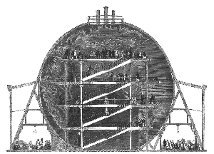
Inside the gas-lit interior of the globe – entered through four loggias – were a series of galleries and stairways which people could climb to explore the concave surface of the earth depicted – complete with plaster-of-Paris mountain ranges and other topographical details, all created to scale – on the inner side of the great orb.

Initially a great success (visitor numbers are believed to have topped a million in its first year), its appeal faded after a few years amid increasing competition from other attractions such as Panopticon of Science and Art (more of that in an upcoming post) and Wyld was obliged to introduce other entertainments to keep the public satisfied. Wyld himself was among those who gave public lectures at the site.

When the lease expired in 1862, the exhibition hall and the globe were both demolished and the globe sold off for scrap. Wyld, meanwhile, apparently didn’t keep his promise to return the gardens to a satisfactory state but after much wrangling over their fate, they were eventually donated to the City of London.

 PICTURE: The Great Globe in cross-section from the Illustrated London News, 7th June, 1851 (via Wikipedia).