10 sites from London at the time of the Magna Carta – 4. Thorney Island…

Houses-of-Parliament2 
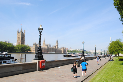
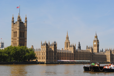
Both Westminster Abbey and the Palace of Westminster (these days better known as the Houses of Parliament – pictured) pre-date 1215 but unlike today in 1215 the upon which they stood was known as Thorney Island.

Formed by two branches of the Tyburn River as they ran down to the River Thames, Thorney Island (a small, marshy island apparently named for the thorny plants which once grew there) filled the space between them and the Thames (and remained so until the Tyburn’s branches were covered over).

One branch entered the Thames in what is now Whitehall, just to the north of where Westminster Bridge; another apparently to the south of the abbey, along the route of what is now Great College Street. (Yet another branch apparently entered the river near Vauxhall Bridge).

The abbey’s origins go back to Saxon times when what was initially a small church – apparently named after St Peter – was built on the site. By 960AD it had become a Benedictine monastery and, lying west of what was then the Saxon city in Lundenwic, it become known as the “west minster” (St Paul’s, in the city, was known as “east minster”) and a royal church.

The origins of the Palace of Westminster don’t go back quite as far but it was the Dane King Canute, who ruled from 1016 to 1035, who was the first king to build a palace here. It apparently burnt down but was subsequently rebuilt by King Edward the Confessor as part of a grand new palace-abbey complex.

For it was King Edward, of course, who also built the first grand version of Westminster Abbey, a project he started soon after his accession in 1042. It was consecrated in 1065, a year before his death and he was buried there the following year (his bones still lie inside the shrine which was created during the reign of King Henry III when he was undertaking a major rebuild of the minster).

Old Palace Yard dates from Edward’s rebuild – it connected his palace with his new abbey – while New Palace Yard, which lies at the north end of Westminster Hall, was named ‘new’ when it was constructed with the hall by King William II (William Rufus) in the late 11th century.

Westminster gained an important boost in becoming the pre-eminent seat of government in the kingdom when King Henry II established a secondary treasury here (the main treasury had traditionally been in Winchester, the old capital in Saxon times) and established the law courts in Westminster Hall.

King John, meanwhile, followed his father in helping to establish London as the centre of government and moved the Exchequer here. He also followed the tradition, by then well-established, by being crowned in Westminster Abbey in 1199 and it was also in the abbey that he married his second wife, Isabella, daughter of Count of Angouleme, the following year. 

LondonLife – Remembering London’s bridges now and then…

Tower-Bridge

Some of 16 hybrid images showing London’s bridges old and new which have been released by the Museum of London Docklands to mark the recent opening of the museum’s new free art exhibition Bridges. The images have been created using historic photographs showcased in the exhibition which opened last Friday and runs until 2nd November. The photographs were taken by renowned late 19th and 20th century photographers, including Henry Grant, Henry Turner, Sandra Flett, Christina Broom, Roger Mayne and George Davison Reid. Above is Tower Bridge, taken by Christina Broom (c. 1903–10) from Shad Thames Jetty. For more, see www.museumoflondon.org.uk/docklands/PICTURE © Christina Broom/Museum of London.

Albert-bridge

Albert Bridge (unknown photographer), Chelsea. Glass lantern slide, c. late 19th century. © Museum of London.

Vauxhall-bridge

Vauxhall Bridge from Cambridge Wharf (taken by Albert Gravely Linney), 1928. Taken from the north bank of the Thames. © Albert Gravely Linney/Museum of London

London-Bridge

Looking north across London Bridge (taken by George Davison Reid), c. 1920s. Taken from inside on the 5th floor of No1 London Bridge. © George Davison Reid/Museum of London

Richmond-Bridge

Richmond Bridge, glass lantern slide, c. late 19th century. Taken from the south side of the river. © Museum of London.

What’s in a name?…Millbank

Millbank

The origins of this Thames-side district of London are as obvious as they sound – it was the site of a mill which stood on the west bank of the river.

The mill, which had served Westminster Abbey since at least the 16th century, stood here until about 1735 when it was demolished and replaced by a mansion built by Sir Robert Grosvenor, a member of the Grosvenor family responsible for developing parts of Mayfair.

The house was pulled down in 1809 to make way for Millbank Prison, which was the country’s first national prison and which was where prisoners were held before their transportation to Australia.

The prison closed about 1890 (a buttress which once stood at the top of the prison’s river steps commemorates the prison – pictured above).

The site is now occupied by some of the more interesting buildings in the area – including the Chelsea College of Arts (buildings formerly used by the  Royal Army Medical School, Tate Britain (which opened in 1897 as the National Gallery of British Art), and a housing development known as the Millbank Estate, constructed to providing housing for 4,500 members of the working class.

While the area was previously known for having been dominated by marshland, land was eventually reclaimed along the waterfront and an embankment established, defining the course of the river.

As well as the district, the name Millbank is also the name of the street which runs along the riverbank between the Houses of Parliament and Vauxhall Bridges.

For more on London’s prisons, check out Geoffrey Howse’s A History of London’s Prisons.

10 of London’s greatest Victorian projects – 6. Victoria and Albert Embankments…

We’ve already mentioned these two riverside embankments as part of our previous piece on Sir Joseph Bazalgette’s revolutionary sewer system. But so important are they to the shape of central London today – not to mention a great place to take a stroll – that we thought they’re also worth a mention in their own right.

Albert-EmbankmentAs mentioned, the Victoria and Albert Embankments (the latter is pictured right) – named, of course, for Queen Victoria and her by then late consort, Prince Albert, who had died in 1861 (see our previous post What’s in a name?…Victoria Embankment) – were located on opposite sides of the River Thames and involved reclaiming a considerable amount of the river so new sewers could be laid.

Construction of Victoria Embankment – which was also seen as a way to relieve traffic congestion in the central London area – started in the mid 1860s and was complete by 1870. Running along the north and western banks of the Thames between Westminster and Blackfriars bridges, its creation involved the demolition of many riverside buildings as a new walk and roadway were constructed behind a wall.

Numerous monuments have since been located along this promenade – they include the Battle of Britain Monument, RAF Memorial and the mis-named Cleopatra’s Needle (see our earlier post to find out why) – as well as a number of permanently berthed ships including the HQS Wellington – the base of the Honorable Company of Master Mariners – and the HMS President.

The walkway also features original decorative lamps – interestingly, Victoria Embankment was the first roadway in London to be permanently lit  by electric-powered lighting (from 1878).

The parks, collectively known as Victoria Embankment Gardens, contain numerous statues and monuments (including one to Bazalgette himself – it’s located close to the intersection with Northumberland Avenue) as well as a bandstand. They also contain the remains of York Watergate – once fronting on to the river, it shows how much land was reclaimed for the project (you can also visit the riverside entrance to Somerset House to gain a feel for where the river once was – look through the glass floor and you’ll see the old riverbank below).

Albert Embankment, meanwhile, runs between Vauxhall and Westminster Bridges on the eastern side of the river. Constructed around the same time as Victoria Embankment, it was designed to prevent flooding of the low-lying areas of Vauxhall and Kennington and to help in Bazalgette’s sewage system plan (although it apparently doesn’t have the same large sewers as can be found on the other side of the river).

Sadly, the demolition did see the centre of what was once the village of Lambeth removed to make way for the new promenade and roadway. But like Victoria Embankment, Albert Embankment features delightfully decorative lamps along the riverfront promenade and is a great place for a walk in any weather.

Where is it? #27…

The latest in the series in which we ask you to identify where in London this picture was taken and what it’s of. If you think you can identify this picture, leave a comment below. We’ll reveal the answer early next week. Good luck!

Well done to Janet Holmes – this is indeed a detail from Vauxhall Bridge. The picture shows Agriculture, one of many statues which adorn the bridge above the piers (this work is on the upstream side).

The statue is the work of Frederick W Pomeroy – Alfred Drury was also commissioned to create female bronze sculptures. It was installed in 1907, a year after the current bridge, a Grade II* listed steel and granite structure, was opened for traffic. Other sculptures by Pomeroy on the upstream side include ArchitectureEngineering and Pottery while the downstream side is adorned with works by Drury – ScienceFine ArtsLocal Government and Education.

The 1906 bridge replaced an earlier bridge built between 1809-16, which was originally named Regent Bridge and later renamed Vauxhall Bridge. It was the first iron bridge over the Thames as well as the first to carry trams and was built on the site of an earlier ferry crossing.

Around London – City’s history goes online; London’s oldest structure discovered?; and, my, how prices have changed…

• Four hundred years of London’s history is being put online as part of a new project on the City of Westminster’s website. The council is publishing a new picture depicting a different historical event from the city’s tumultuous history every day throughout 2011 under its A date with history project. The images, taken from the council’s archives, include photographs, engravings and sketchings. They include a black and white photo of queues of people waiting on Vauxhall Bridge to pay their final respects to King George V lying in state at Westminster Hall after his death on 20th January, 1936, another photograph showing the King and Queen with PM Winston Churchill inspecting damage to Buckingham Palace’s swimming pool following a raid during the Blitz in September, 1940, a hand-colored print depicting the execution of King Charles I on 30th January, 1649, and an engraving showing a comet passing by the spire of St Martin in the Field in 1744. It is the first time the images have been made freely available online. To see the images, head to www.westminster.gov.uk/archives/day-by-day.

What could be London’s oldest structure has been unearthed on the Thames foreshore. Six timber piles up to 0.3 metres in diameter have been discovered only metres from the MI6 headquarters in Vauxhall, part of what archaeologists believe is part of a prehistoric structure which stood on the river bank more than 6,000 years ago during the Mesolithic period when the river was lower. The find, made by a Thames Discovery Programme team, is only 600 metres away from a Bronze Age timber bridge or jetty dating from 1,500 BC which was discovered in 1993. The piles may be able to be seen from Vauxhall bridge during low tides between 10.25am on 22nd January and 11.15am on 23rd January.

Homes in London were purchased for an average price of £14,000 back in 1910, according to land tax valuations documents released online this week. Ancestry.co.uk has placed the London, England Land Tax Valuations 1910 – compiled as part of David Lloyd George’s 1910 Finance Act, known as the Domesday Survey – online to help people discover more about the financial situations of their ancestors. The documents put the value of the Bank of England at £110,000, the Old Bailey at £6,600, and Mansion House at a more impressive £992,000. The average value of property on Fleet Street was £25,000 (compared with £1.2 million today) while in Cannon Street, the average value was £20,000 (£2.2 million) and in Chancery Lane, the average value was just £11,000 (£1.1 million).