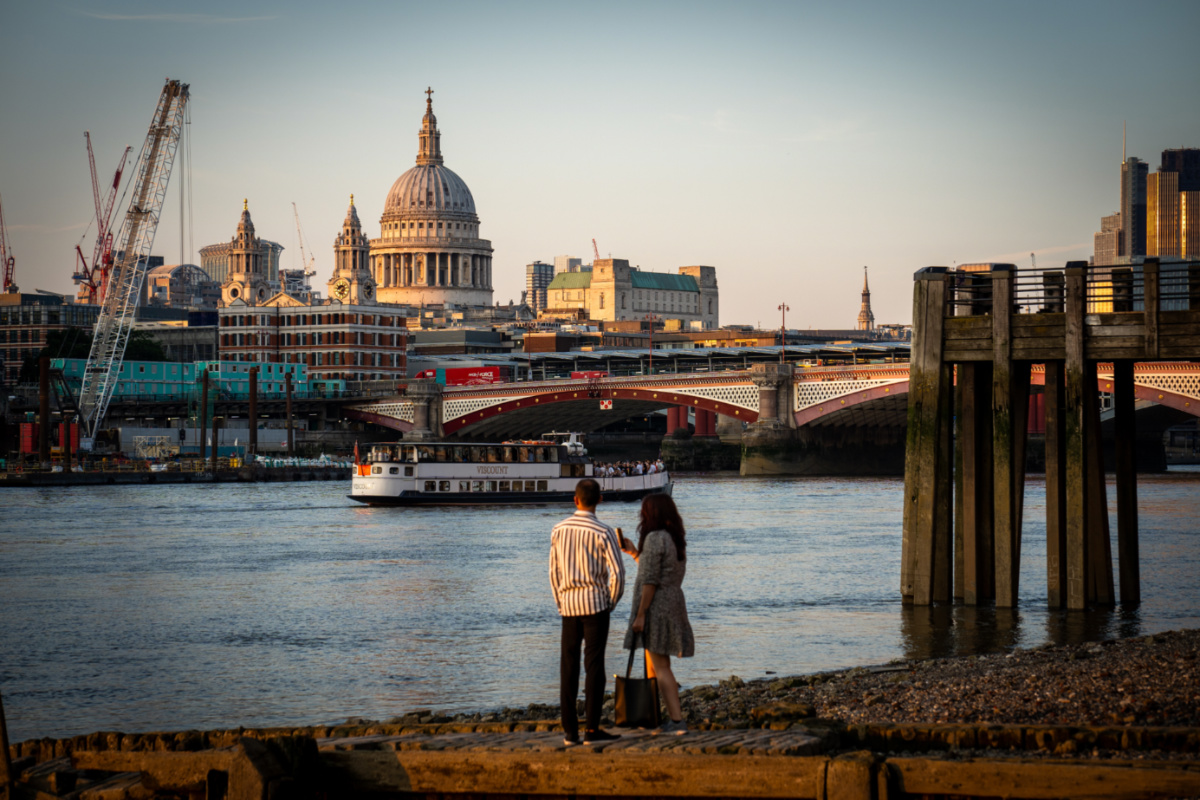
LondonLife – On the Thames shore…
Baynard’s Castle actually refers to two buildings – a Norman fortification demolished in the early 13th century and a later medieval palace located to the east of the original structure. This week we’re looking at the first of those buildings – the Norman fortification.
 The first Baynard’s Castle was built in the late 11th century by Ralph Baynard (Baignard) and is believed to have replaced an earlier fortification at the site at the junction of the Thames and the Fleet rivers (the river now emerges into the Thames under Blackfriars Bridge).
Baynard (his name may be the origin of the name for Bayswater – Baynard’s Watering place – see our earlier post here), was the sheriff of Essex and a supporter of William the Conqueror.
The castle – which is said to have featured walls and parapets and which is generally said to have been on the waterfront (although some have said it was located inland) – remained in Baynard’s family until the reign of King Henry I when in 1111, his grandson William Baynard apparently forfeited his lands for supporting Henry’s eldest brother and would-be king, Robert Curthose.
It was later passed to the King’s steward Robert Fitz Richard, son of the Earl of Clare, and is known to have been inherited by his grandson, Robert Fitzwalter.
Fitzwalter, however, was a key opponent of King John and as early as 1212 he was in hot water for his part in a conspiracy against the king, although he stated it was because the king tried to seduce his daughter, Matilda the Fair. Either way, he escaped trial by heading to France and John seized the opportunity to raze the castle which he did on 14th January, 1213.
Fitzwalter was later forgiven under an amnesty and went on to play a leading role among the baronial opposition to Kong John – he was among 25 barons charged with enforcing the promises of the Magna Carta of 1215.
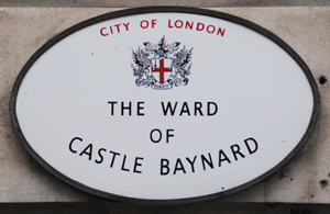
The name Baynard’s Castle is remembered in the London ward of Castle Baynard (pictured) which covers the area in which it once stood.
Held during particularly cold winters when the River Thames froze over, ‘frost fairs’ had been part of London’s history, from the Middle Ages up until the last one was held in February 1814, two hundred years ago last month.
The five day revelry started on 1st February and took place on a stretch of the river between Blackfriars and London Bridge (it was the medieval London Bridge in particular – with its 19 arches and wide piers – which helped to slow the river enough to freeze, something unlikely to happen again with the current bridge).
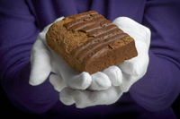 People began to venture out onto the ice and an impromptu fair started taking shape as tents and booths were established selling all manner of food including roast ox, drinks including alcohol like gin as well as hot chocolate, tea and coffee, and souvenirs to take advantage of the passing traffic (a piece of gingerbread from the fair is a star attraction at the Museum of London’s current exhibition on the fair – pictured right). Some of the tents were known by names (similar to a pub sign), such as the Moscow and the Wellington.
Other attractions recorded include children’s play equipment, a gambling den, and printing presses which produced keepsakes to mark the occasion. There were even reports of sightings of an elephant crossing the river.
Several people apparently died at the fair having sunk beneath the ice by the time the snow turned to rain and the ice began to break up. An engraving of the frost fairs by Richard Kindersley can be found on a pedestrian walkway underneath the Southwark end of Southwark Bridge.
The dates for Frozen Thames: Frost Fair 1814 at the Museum of London have been extended until 21st April (there is an accompanying exhibition, Frozen Thames: Frost Fair 1684 running concurrently at the Museum of London Docklands). Admission is free. For more, see www.museumoflondon.org.uk.
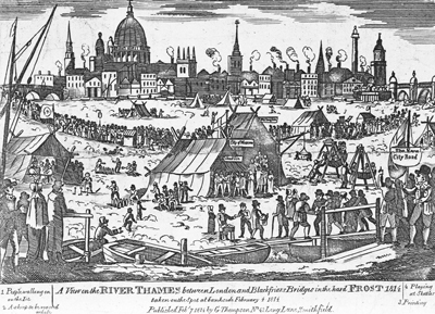
MAIN PICTURE: A view of the river Thames, 1814, George Thompson © Museum of London. This print shows the 1814 Frost Fair from the south bank of the Thames, with St Paul’s in the background.
We’ve already mentioned these two riverside embankments as part of our previous piece on Sir Joseph Bazalgette’s revolutionary sewer system. But so important are they to the shape of central London today – not to mention a great place to take a stroll – that we thought they’re also worth a mention in their own right.
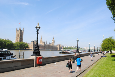 As mentioned, the Victoria and Albert Embankments (the latter is pictured right) – named, of course, for Queen Victoria and her by then late consort, Prince Albert, who had died in 1861 (see our previous post What’s in a name?…Victoria Embankment) – were located on opposite sides of the River Thames and involved reclaiming a considerable amount of the river so new sewers could be laid.
Construction of Victoria Embankment – which was also seen as a way to relieve traffic congestion in the central London area – started in the mid 1860s and was complete by 1870. Running along the north and western banks of the Thames between Westminster and Blackfriars bridges, its creation involved the demolition of many riverside buildings as a new walk and roadway were constructed behind a wall.
Numerous monuments have since been located along this promenade – they include the Battle of Britain Monument, RAF Memorial and the mis-named Cleopatra’s Needle (see our earlier post to find out why) – as well as a number of permanently berthed ships including the HQS Wellington – the base of the Honorable Company of Master Mariners – and the HMS President.
The walkway also features original decorative lamps – interestingly, Victoria Embankment was the first roadway in London to be permanently lit by electric-powered lighting (from 1878).
The parks, collectively known as Victoria Embankment Gardens, contain numerous statues and monuments (including one to Bazalgette himself – it’s located close to the intersection with Northumberland Avenue) as well as a bandstand. They also contain the remains of York Watergate – once fronting on to the river, it shows how much land was reclaimed for the project (you can also visit the riverside entrance to Somerset House to gain a feel for where the river once was – look through the glass floor and you’ll see the old riverbank below).
Albert Embankment, meanwhile, runs between Vauxhall and Westminster Bridges on the eastern side of the river. Constructed around the same time as Victoria Embankment, it was designed to prevent flooding of the low-lying areas of Vauxhall and Kennington and to help in Bazalgette’s sewage system plan (although it apparently doesn’t have the same large sewers as can be found on the other side of the river).
Sadly, the demolition did see the centre of what was once the village of Lambeth removed to make way for the new promenade and roadway. But like Victoria Embankment, Albert Embankment features delightfully decorative lamps along the riverfront promenade and is a great place for a walk in any weather.
As London undergoes the big chill with much of the rest of the country, we thought we’d take a quick look at the frost fairs which were once held on top of the frozen River Thames.
While records reveal the Thames froze over as far back as the city’s Roman era, the first recorded ‘frost fair’ dates from the mid-16th century (Queen Elizabeth I is said to have attended one in 1564) while the last was held in 1814.
 While the lower temperatures played a role in allowing the ice to get thick enough to hold frost fairs on top (the period between the 14th and 19th centuries is known as the ‘Little Ice Age’ in northern Europe), so too did the fact that the Thames was broader and shallower than it is now, not to mention the narrow arches of Old London Bridge (it was demolished in 1831 – for more on this, see our earlier entry) which slowed the waters of the Thames.
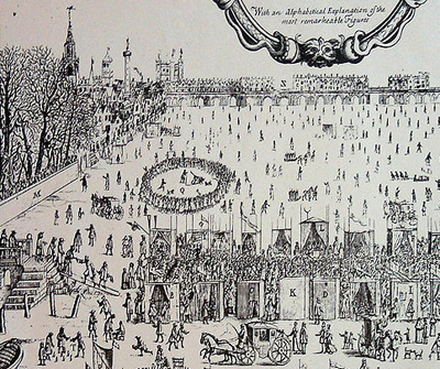
The fairs were set up in a range of locations along the river. Descriptions of them talk of a range of activities being carried out on the river’s frozen surface – yes, the use of sleds and skates but also things like bear-baiting, coach, horse racing, dancing and puppet plays as well as the setting up of booths or stalls from which traders sold food, souvenirs, and, importantly, drink.
One of the longest of the fairs – recorded by diarist John Evelyn – was held over the winter of 1683-84 and located between Temple and Southwark. It featured streets of stalls with different traders grouped in different areas. King Charles II himself was a visitor.
During the last and biggest frost fair, held on the river near Blackfriars Bridge, a street known as ‘City Road’ ran down the middle of the Thames and donkeys gave people rides.
There is a frieze depicting a ‘frost fair’ underneath the southern end of Southwark Bridge.
PICTURE: Detail of an image of the Frost Fair of 1684 with London Bridge in the background. Source: Wikipedia.
Built in the 16th century for King Henry VIII, Bridewell Palace only had a short-lived life as a royal residence before it was handed over to the City of London and used as a poorhouse and prison.
 Located on the western bank of the Fleet River (the site is now occupied by Unilever House and remembered in the place names of Bridewell Place and Bridewell Court), the palace – named for a holy well located nearby which was dedicated to St Bride (St Brigid) – was built on the direction of the king’s key advisor Cardinal Thomas Wolsey between 1510-15 on land which had previously been the site of St Bride’s Inn.
In 1515 Cardinal Wolsey gave it to King Henry VIII after taking up residence at Hampton Court and York Place – Henry was looking for a royal residence in London after the Palace of Westminister was largely destroyed in a fire in 1512. Work continued on the palace until its completion in 1523.
The palace, the site of which is now marked with a plaque on the approach to Blackfriars Bridge, consisted of two courtyards surrounded by brick buildings with the three storey royal lodgings (separate quarters for the king and queen) located around the inner courtyard and entered by a grand staircase from the outer courtyard. It also featured a watergate was located on the Thames and, interestingly, Bridewell was the first royal palace not to have its own great hall.
Among historic events hosted here was the visit of the Holy Roman Emperor Charles V in 1522 (the emperor did not stay here but his entourage did). In 1528 meetings of the papal delegation took place at Blackfriars (located next door and joined by a specially built gallery) to discuss the king’s divorce from Queen Katherine of Aragon – it’s here that the Queen made her most famous speech declaring her fidelity to the king – and for its duration the king and queen lodged at Bridewell. It’s also said that it was at Bridewell Palace that artist Hans Holbein the Younger painted his famous work – The Ambassadors (see our earlier post on this here).
Following Cardinal Wolsey’s fall from favor in 1529, King Henry VIII no longer used the property (he took over the Palace of Whitehall, then known as York Place, as his main residence in 1530 – for more on this see our earlier post here). It was leased for much of the following decade to the French ambassador in London before, following petitioning for a new hospital for the poor from Nicholas Ridley, the Bishop of London, King Edward VI gave it to the City of London in 1553. They took over fully in 1556 and converted the palace into a prison, hospital and workrooms (we’ll deal in detail with the prison in an upcoming post).
While there’s been a bridge over the River Thames near where London Bridge now stands since Roman times, the bridge which is currently there was built in the early 1970s. To find Greater London’s oldest surviving bridge across the Thames we have to head to Richmond in the city’s west.
 The 300 foot long stone arch bridge, made from Portland stone, was built between 1774-77 and replaced a ferry crossing between Richmond to the east and East Twickenham to the west (this had apparently been in operation since shortly after the Norman Conquest and at the time it was discontinued consisted of two vessels – a passenger craft and a ‘horse boat’).
Designed by James Paine and Kenton Couse and built by Thomas Kerr, the bridge features five arches including a 60 foot wide central span which was big enough for larger watercraft and gave the bridge its rather humpbacked appearance. Its construction was privately funded with the £26,000 required to build the bridge partly raised via tontine schemes under which subscribers paid an agreed sum into a fund after which they each receive an annuity, the value of which increases as members of the fund die off.
Initially a toll bridge (the tolls – which were 1/2d for passengers and up to 2s 6d for coaches drawn by six horses – were ended in 1859 when the last tontine shareholder died), the bridge was widened in the late 1930s but – now a Grade I listed structure – remains essentially true to its original design.
It was the eighth bridge to be built across the the Thames in Greater London but is now the oldest still standing (among those which predated it but have been demolished are London Bridge, Westminster Bridge and Blackfriars Bridge) and has been featured in paintings by the likes of Thomas Rowlandson, John Constable and JMW Turner.
Seven of London’s bridges are being lit up at night until 10th September in an initiative called “Dazzle”. Being run under the Mayor of London Presents program, it celebrates the 50 evenings of the Olympic and Paralympic Games. Here’s just a sample of what you can see…

The most iconic of London’s bridges, Tower Bridge has been a focal point for Olympic celebrations. One of the great structures of Victorian London, it was opened in 1894 and at the time was largest bascule bridge ever built (for more on Tower Bridge, see our earlier post here).

The most recent version of London Bridge, this links Borough High Street in Southwark (you can see Southwark Cathedral in the background) and King William Street in the City and was built in the late 1960s/early 1970s and opened by Queen Elizabeth II in 1973. There have been bridges in this vicinity since as far back as Roman times (for more on the history of London Bridge, see our earlier post here).

The current Southwark Bridge – which links the City of London with the heart of Southwark – dates from 1921 and replaced an earlier bridge designed by John Rennie.

Initially plaqued by the wobbles, the steel suspension walk bridge known as Millennium Bridge is the newest of the bridges that cross the Thames in central London, linking St Paul’s Cathedral on the north bank with the Tate Modern on the south (the looming bulk of which is pictured here). First opened in July 2000, it was closed after concerns over its movement and then reopened to the public in 2002.
Other bridges taking part in Dazzle but not shown here include the Golden Jubilee footbridges, Waterloo Bridge and Blackfriars Bridge.
For more on the program, see www.molpresents.com/dazzle.
PICTURES: All images courtesy of the City of London Corporation.
