LondonLife – Sunset on Euston Road…
This year marks the 200th anniversary of Mary Shelley’s thought-provoking novel, Frankenstein or, The Modern Prometheus, so we thought that before the year is out (the novel was actually published in January, 1818), we’d take a look 10 London locations integral to her story.
 First up, it’s to Somers Town, which lies just to the north of Euston Road, where Mary Wollstonecraft Godwin (later Mary Shelley) was born on 30th August, 1797, the second child of feminist writer Mary Wollstonecraft and journalist, philosopher and novelist William Godwin.
Wollstonecraft sadly died 12 days after the birth due to complications. Mary was left in the care of her father and half-sister Fanny Imlay (Wollstonecraft’s first child whose father was an American adventurer named Gilbert Imlay) and, after her father remarried in 1901, a step-mother Mary Jane Clairmont (with whom Mary would have an acrimonious relationship).
While Mary was provided with little formal education during her childhood, her father saw that she received a broad education in a range of subjects, generally described as unusually advanced for the time.
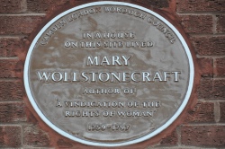
The family’s home was located at number 29 in the Polygon Building on the north side of Clarendon Square – it was demolished in 1904 and the site is now occupied by a block of council flats called Oakshott Court. There’s a commemorative plaque to Wollstonecraft on the side of the complex in Werrington Street – it was erected by the Camden London Borough Council (pictured).
Mary Shelley, meanwhile, is also commemorated in a mural in Polygon Road which depicts many of the famous figures associated with the area (her parents and future husband Percy Bysshe Shelley are also depicted in it). The mural, the work of Karen Gregory, was commissioned by the Greater London Council in the 1980s.
PICTURE: Ellaroth (licensed under CC BY-SA 3.0)
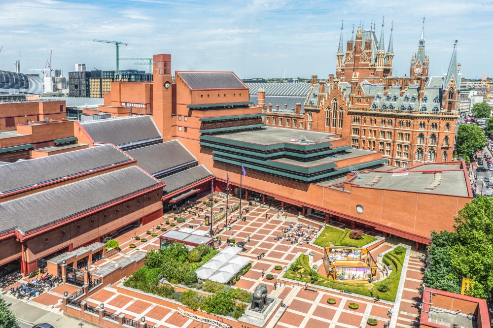
This week marked 20 years since the British Library’s St Pancras building was officially opened, so we thought it timely to take a look at this London ‘treasure’.
Located on Euston Road, the building, complete with rather grand piazza, was designed by architect Sir Colin St John Wilson and his partner MJ Long.
The largest public building to be constructed in the 20th century in the UK, it was designed specifically to house the British Library collections – which itself had only been created in 1972 when an act was passed by Parliament.
The building – which did draw some criticism over its design when it was completed but has been embraced by the public – was officially opened by Queen Elizabeth II on 25th June, 1998.
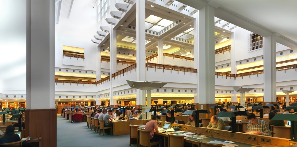
Grade II-listed since 2015, it’s comprised of 112,000 square metres spread over 14 floors – including five below ground – and features 11 reading rooms specialising in various subject areas including one for ‘manuscripts’, another for ‘maps’ and another for ‘rare books and music’.
The centrepiece of the building is the King’s Tower which is home to the library of King George III and the Sir John Ritblat Treasures of the British Library Gallery.
The collection housed at the library includes more than 150 million items. Highlights – many of which are housed in the Treasures Gallery – include a copy of the Magna Carta, the Lindisfarne Gospels, and Leonardo da Vinci’s notebook as well as a first edition of The Times (18th March, 1788), manuscripts by everyone from Jane Austen and James Joyce to Handel and the Beatles, and the Diamond Sutra, the world’s earliest dated printed book.
The library, which also hosts temporary exhibitions, is also home to a restaurant, cafe and several coffee shops as well as its own retail shop.
There are now plans to further develop the campus by expanding onto a 2.8 hectare site at its northern end with the aim, among other things, of creating more exhibition spaces, new learning facilities and a permanent home for the Alan Turing Institute, the UK’s national centre for data science and artificial intelligence. A joint venture led by Stanhope plc, working with architects Rogers Stirk Harbour + Partners (RSHP), won a competitive process to undertake the development last year.
WHERE: British Library, 96 Euston Road (nearest Tube stations are Kings Cross St Pancras, Euston and Euston Square); WHEN: 9.30am to 6pm (includes Treasures Gallery – exhibition times can vary); COST: Free (but admission fees may be charged for exhibitions); WEBSITE: www.bl.uk.
PICTURE: Top – Aerial view of the St Pancras building (Tony Antoniou); Below – One of the reading rooms (Paul Grundy).
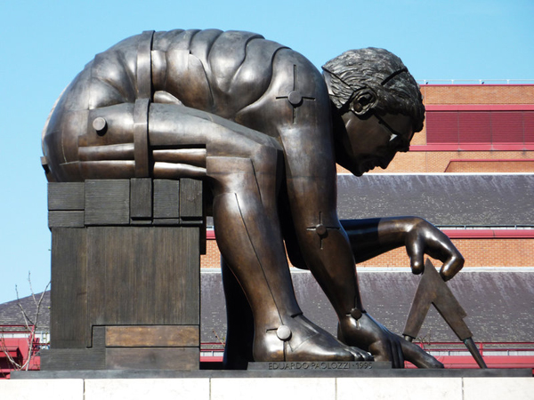
This tribute to Sir Isaac Newton by artist Eduardo Paolozzi shows him in the unusual pose of being seated and leaning over with compass in hand. Installed in the British Library‘s courtyard off Euston Road in 1997, the 12 foot high bronze is based on a large watercolour by Romantic Age poet and artist William Blake, one of a series of 12 he produced in Lambeth in the 1790s. It’s on show at the Tate Britain. The statue was given a voice in 2014 as part of the Talking Statues project. PICTURE: British Library.
 The name Euston first makes an appearance in London in the Georgian era when Euston Square was laid out north of the City.
The moniker came from the square’s landlord, the Duke of Grafton, who owned a country seat called Euston Hall near Thetford in Suffolk, and apparently derives from the Anglo-Saxon ‘Efe’s Tun’ meaning the ‘farmstead of a man called Efe’.
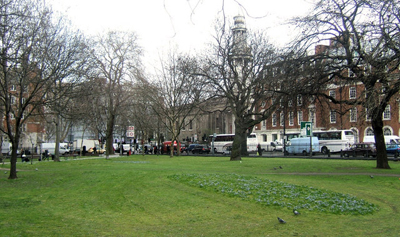
The now much altered square (the gardens of which are pictured) was originally developed in the 1820s; in the 1850s the New Road – which had been developed by the second Duke of Grafton, Charles Fitzroy, in the 1730s to take farm traffic off Oxford Street and Holborn – was renamed Euston Road.
It only makes sense then that when the mainline station on that road was developed in the 1830s (it opened in 1837, exactly a month after Queen Victoria became the monarch), it too was named Euston (as was the now long-gone Euston Arch – see our earlier post here).
Euston Underground Station opened in 1907 while Euston Square Underground station, which originally opened as Gower Street in 1863, was renamed Euston Square in 1909.
Interestingly the area around Euston Road also features numerous references to Grafton in honour of the duke – Grafton Street, Grafton Place and Grafton Way among them – while other streets also have links to the names of the dukes’ family – Warren Street (which also lends its name to a Tube station), for example, is named for Anne Warren, the wife of the second duke’s grandson.
PICTURE: Kevin Gordon/CC BY-SA 2.0
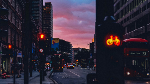
 Says the photographer, ‘Sam’: “I was walking north towards Camden, and coming out on Euston Road I saw the light fading to the west and it caught my eye. It’s a busy shot, but I tried to get the lamppost on the left to line up with the building in the background to give it some structure. You can’t really mess up a picture at sunset – the light is so dramatic at that time of day that generally whatever you do it’ll work out!” For more of the photographer’s work, see www.flickr.com/photos/–sam–/
Taken an interesting photograph of somewhere in London? We’re always looking for interesting images of the city so if you’ve got one you reckon captures a snippet of life in London, please contact us at exploringlondon@gmail.com or via our new Flickr group at www.flickr.com/groups/exploringlondon/
The location now known as King’s Cross, north-west of the City, takes its name from a monument adorned with an 11 foot high statue of King George IV which once stood on a site now occupied by King’s Cross Railway Station.
The area had been previously known as Broadford Bridge or Battlebridge – the latter a name many associated with the apparently erroneous belief that it was here, at a bridge which once crossed the River Fleet, the Iceni Queen Boudicca (also known as Boadicea) ill-fatedly confronted the Roman Army under the command of Gaius Suetonius Paulinus.
From the 1830’s (King George IV ruled from 1820 to 1830), however, the area took on the name of King’s Cross thanks to the erection of what Walter Thornbury described in his 1878 text, Old and New London, as a “ridiculus octagonal structure crowned by an absurd statue of George IV”.
The structure, said to be 60 feet high, was erected at the intersection of Gray’s Inn Road, Pentonville Road and what we now know as Euston Road, and during its relatively short lifespan, was employed at different times as a police station and as a pub (complete, apparently, with a camera obscura in the upper level).
It was completely removed by 1845 (King’s Cross Railway Station officially opened in 1852).
The area of King’s Cross has been settled back as far as Roman times – St Pancras Old Church is one of the oldest sites of Christian worship in England although the current church is Victorian – but it wasn’t until the 1700s and 1800s that it was transformed in to an urban area with the arrival of canals – including The Regent’s Canal – and the railways.
Traditionally one of London’s poorest areas, it survived World War II bombings but subsequently suffered as the railways declined in the post-war period. By the 1980s, it had become notorious as a red light district.
It has since gone through – and is still going through – a gradual gentrification process, however, with the 67 acre development King’s Cross Central among the projects currently under construction.
Key attractions of the area include The British Library, The London Canal Museum, arts centre King’s Place, and the recently refurbished St Pancras Renaissance London Hotel.
It’s also now home to St Pancras International – London’s Eurostar terminus (having been moved here from Waterloo) – as well as King’s Cross Railway Station which is believed by many, despite the lack of any evidence, to be the burial site of Queen Boadicea (it’s said she still lies beneath platform 9 or 10) and which is the home of the fictitious platform 9 and 3/4 from which Harry Potter catches the train to Hogwarts.
Famous for its literary, intellectual and artistic heritage, Bloomsbury covers an area in central London which lies between Holborn and Euston Road.
The area, which became a fashionable residential district in the 17th and 18th centuries, derives its name from an earlier era and is named after William de Blemund (‘Blemundsbury’ means the manor of Blemund), who acquired land there in 1201.
It was later owned by the Earl of Southampton, who had begun developing the area in the 1660s – a task which was continued when the land passed, through the marriage of his daughter, into the hands of the Dukes of Bedford. Successive dukes were then involved – to varying degrees – in the development of series of residential squares and streets which eventually included the likes of Bedford, Russell and, of course, Bloomsbury Squares.
In the early 20th century, the area become home to what is known as the Bloomsbury Group – its members included the writers Virginia Woolf, Lytton Strachey and EM Forster. These days the area is noted for being home to the British Museum (first opened to the public in 1759) and the University of London.
