Famous Londoners – The Unknown Roman Girl…

GherkinIn an unusual ‘Famous Londoners’, this week we’re looking at a former inhabitant of London who we still know relatively little about.

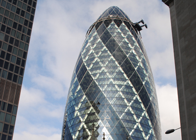
The remains of the teenaged girl – believed to have been aged between 13 and 17 years – were found in 1995 when the conically-shaped skyscraper at 30 St Mary Axe, fondly known as the Gherkin (and then formally known as the Swiss Re Tower), was being constructed.

The girl, whose skeleton was unearthed where the foundations now stand, was buried sometime between 350 and 400 AD in what appeared to be an isolated grave which would have lain just outside the edge of early Roman Londinium.

The body lay with the girl’s head to the south and the arms folded across. Pottery was found associated with the body which provided dating information.

After being exhumed, the skeleton was housed at the Museum of London for some 12 years before in 2007 it was reburied near the new building. The burial featured a ceremony at nearby St Botolph-without-Aldgate followed by a procession to the gravesite where a dedication took place which included “music and libations”. Among those who attended was the Lady Mayoress of the City of London.

There’s an inscription in honour of the girl on a stone feature outside the building in both Latin and English while a stone set in the pavement decorated with laurel leaves marks the (re)burial spot.

Other recent Roman remains found in London include the skeleton of a young Roman woman, believed to date from the 4th century, which was found still inside its sarcophagus at a site in Spitalfields and a series of two dozen Roman-era skulls which, likely to date from the first century A, were found during excavations for the Crossrail project in 2013. It has been suggested they may have been Britons executed for their role in the famed Queen Boudicca’s rebellion against the Romans in 61 AD.

What’s in a name?…Fulham…

Fulham-PalaceThis Thameside area in London’s west has a long and storied history and its name is a reflection of it.

Long home to the ‘country’ manor of the bishops of London (Fulham Palace, pictured above), the name Fulanham is recorded as early as the late 7th century.

While there’s been speculation in the past that the name Fulham (also recorded among other variations as Fullam) was a corruption of ‘fowl-ham’ – relating to the wild fowl that were to be found here – or of ‘foul-ham’, relating to the muddied waters, that’s now apparently generally deemed not to be the case.

Instead, its name most likely owes its origins to an Anglo-Saxon named Fulla and the Old English word ‘hamm’ – a term for a water meadow or piece of land enclosed in a bend in a river (in contrast to the more common ‘ham’ which refers to an estate or homestead) – and referred to the manor he owned here, its boundaries set by a bend in the Thames. (It should be noted there is evidence of earlier occupation of the site by the Romans and as far back as the Neolithic era).

In about 700, the manor of Fulham – which includes the area we now think of as Fulham as well as land stretching as far afield as Acton, Ealing and Finchley – was acquired by Bishop Waldhere of London from Bishop Tyrhtilus of Hereford. Since Tudor times, Fulham Palace was used as the country home of the bishops of London and in the 20th century became their principal residence. It was used as such until 1975 and now houses a museum and reception rooms.

As well as now being used for the area which once contained what became the village of Fulham itself, since 1979 the name has also been used in that of the Borough of Hammersmith and Fulham. Interestingly, Fulham Broadway tube station was known as Walham Green when it first opened in 1880 and was only given its current name in 1952.

The bishop’s palace (and the nearby riverside Bishop’s Park) aside, other landmarks in the area include the Grade I-listed All Saints Church, which is largely late Victorian and which hosts the grave of abolitionist Granville Sharp, and the nearby Powell Almhouses which date from 1869.

It’s also linked by Putney Bridge with Putney on the other side of the Thames; the current bridge is the work of Sir Joseph Bazalgette and was built in 1882 – it replaced an earlier wooden bridge built in 1729 and overlooks where the annual Oxford-Cambridge Boat Race begins (other bridges spanning the river from Fulham include the rather ugly Wandsworth Bridge).

Known during the 18th century as something of a mecca for gambling, prostitution and other debauched leisure activities, these days Fulham is known for its football club, Fulham FC headquartered at Craven Cottage stadium (named for a cottage owned by Baron Craven which once stood here), shopping and is a sought-after residential location.

Daytripper – Maiden Castle…

Maiden-Castle

Located just outside the town of Dorchester in southern Dorset to the south-west of London, Maiden Castle is the largest extant Iron Age hillfort known to have been built in Britain and among the largest and most complex in all of Europe.

Featuring multiple earthen ramparts (pictured above is the ditch between two of them) – from the top of which you can see spectacular views of the surrounding countryside – and well-defended entrances, it would have once been home to several hundred people. It’s been speculated the name may come from the Celtic word “mai-dun”, meaning a great hill.

Maiden-Castle2The first archaeological excavations were carried out here in the 1930s by Mortimer Wheeler and then later in the 1980s.

Initially built between 800 and 550 BC, the first Iron Age hillfort – built on the site of an earlier Neolithic enclosure with settlement dating back some 6000 years – was enclosed by a single rampart.

In the middle Iron Age, between 550 and 300 BC, it was extended to some 19 hectares or 50 football fields and, apparently densely populated with “round houses” which over time were organised into an increasingly regimented layout, eventually become the pre-eminent settlement in southern Dorset.

In the late Iron Age, the settlement became focused on the eastern end of the fort and with the arrival of the Romans and their establishment of the town of Dorchester (Durnovaria), it was finally abandoned.

Among the features identified within the hillfort’s precincts are well-defended and complex entrances at the western and eastern ends and a large Iron Age cemetery just outside the eastern entrance.

Discovered by Sir Mortimer, the cemetery contained more than 52 burials, some of which held the remains of males with terrible injuries. While Sir Mortimer believed it was a war cemetery created following a battle between the locals and the Roman, it is now thought to have been used as a more general cemetery over a longer period of time.

The remains of a Romano-British temple (pictured above right), dating from the late 4th century AD – about 200 years after the site was abandoned, has also been found inside the hillfort’s boundaries. It consisted of a central room surrounded by a passage with a portico open to the weather. Nearby is what is believed to have been a shrine and a two roomed building thought to have been a priest’s house. A bronze plaque depicting the goddess Minerva has been found on the site, suggesting the temple have been dedicated to her.

The site is managed by English Heritage who have an MP3 audio tour you can download from the website and play on an iPod, smart phone or MP3 player to give an extra dimension to your visit!

WHERE: Maiden Castle, two miles south of Dorchester, off A354, north of bypass or train – two miles from Dorchester South/West; WHEN: Any reasonable time in daylight hours; COST: Free; WEBSITE: www.english-heritage.org.uk/daysout/properties/maiden-castle/

For more on Iron Age Britain, check out Barry Cunliffe’s Iron Age Britain (English Heritage).

10 significant sites from Georgian London – 4. St Martin-in-the-Fields…

This iconic church on the edge of Trafalgar Square, known for its musical associations, is another of the works of architect James Gibbs and, as with St Mary le Strand, the current building was constructed in the first half of the 18th century to replace an earlier building.

St-Martin-in-the-fieldsThe first references to a church on the site of the present building date back to the 13th century when, constructed upon a Roman burial site, it was apparently used by monks from Westminster. It was replaced by King Henry VIII around 1542 and enlarged in 1602 before finally being demolished in 1721.

Gibbs’ apparently first suggested the design feature a round nave with a dome over the top but the proposal was rejected as too expensive and a simpler, rectangle-shaped church was subsequently agreed upon and eventually completed in 1726. Part of the design inspiration comes from Sir Christopher Wren, although Gibbs’ integration of the tower into the church was a departure from Wren’s designs (the church spire rises 192 foot into the air).

Among the features of the interior are ceiling panels in the nave which feature cherubs and shells and are the work of ceiling experts Giuseppe Artari and Giovanni Bagutti. Other items of interest include Chaim Stephenson‘s sculpture, Victims of Injustice and Violence, remembering all victims during apartheid in South Africa (it was dedicated by Desmond Tutu in 1994), a statue of St Martin and the Beggar by James Butler, and, on the porch, Mike Chapman‘s sculpture marking the millennium, Christ Child. Paintings include one of James Gibbs himself by Andrea Soldi and dating from 1800.

Among those buried in the church are furniture-maker Thomas Chippendale, sculptor Louis-François Roubiliac and notorious robber Jack Sheppard (he’s buried in the churchyard). The crypt also contains a life-sized marble statue of Henry Croft, London’s first pearly king, which was moved there from St Pancras Cemetery in 2002.

As well as being the location of the first religious broadcast, its musical heritage includes performances by Handel and Mozart and being the location of the first performance of its namesake chamber orchestra, the Academy of St Martin in the Fields.

Since the early 20th century, the church has been noted for its work with the homeless (thanks in particular to the work of Vicar Dick Sheppard). Meanwhile, its connections with music – which date back to its rebuilding – continue in the concerts held in the crypt cafe. The crypt also hosts art exhibitions.

The church underwent a £36 million renewal project in the Noughties. Additions included the new east window by Shirazeh Houshiary.

WHERE: St Martin-in-the-Fields on the north-east corner of Trafalgar Square (nearest tube stations are Charing Cross, Leicester Square and Embankment); WHEN: Open weekdays and weekends – times vary, see website for details; COST: free; WEBSITE: www.stmartin-in-the-fields.org.

What’s in a name?…Gracechurch Street…

This central London thoroughfare runs through the heart of the City of London and has been a main thoroughfare since Roman times.

Gracechurch-StreetStretching from Eastcheap (near the Monument) to Leadenhall Street, the street runs over the site of what was Roman London’s forum and basilica (see our earlier post on the Roman buildings here).

The name, meanwhile, comes from the former medieval church of St Benet Gracechurch which was once located on the corner of Gracechurch and Fenchurch Streets.

The church, which was destroyed in the Great Fire of 1666 but rebuilt by Sir Christopher Wren before finally being demolished in 1876, was named for St Benedict (St Benet is a short form) while Gracechurch – which was used after the Great Fire – was a corruption of Grasschurch, a reference to it being located near a hay market (in fact, the church was also known as St Benet Grass). The street was also known as Gracious Street.

Landmarks along Gracechurch Street including the Leadenhall Market (see our earlier post here) and a 30s-inspired modern building of note which stands at number 20.

PICTURE: Looking down Gracechurch Street toward the Monument.

For more on London’s Wren churches, see John Christopher’s Wren’s City of London Churches.

London Pub Signs – Ye Olde Watling…

Ye-Olde-WatlingThis pub, located in the City, takes its name from the street upon which it stands – Watling Street.

The street, which is just 180 metres long, bears the same name as a great Roman road which ran all the way from Dover through London to the long gone Roman town of Viroconium (now known as Wroxeter in Shropshire).

The Roman road followed, to some extent, the route of an ancient Celtic pathway. But while the Celtic pathway crossed the Thames at Westminster, the Roman road, once the bridge was constructed, crossed at London Bridge and headed through London, apparently taking in this surviving piece.

The building itself – located on the intersection with Bow Lane – is said to have been constructed from old ship’s timbers by none other than Sir Christopher Wren in 1668. The upstairs rooms were said to have been used as a drawing office during the construction of Wren’s masterpiece, St Paul’s Cathedral. It may have also been used as  pub by the workmen building the cathedral – in fact it’s said to have been the first pub built after the Great Fire of 1666.

The pub is part of the Nicholson group. For more on it, check out www.nicholsonspubs.co.uk/yeoldewatlingwatlingstreetlondon.

PICTURE: Duncan Harris/Wikipedia

What’s in a name?…Barbican

Though it’s these days associated with a Brutalist housing estate and performing arts centre based in the north of the City of London, the name Barbican has been associated with the area on which the estate stands for centuries.

BarbicanThe word barbican (from the Latin barbecana) refers to an outer fortification designed to protect the entrance to a city or castle. In this case it apparently referred to watchtower which may have had its origins in Roman or Saxon times (or maybe both). The City of London website suggests it was located “somewhere between the northern side of the Church of St Giles Cripplegate and the YMCA hostel on Fann Street”.

When-ever it was built, the watchtower was apparently demolished on the orders of King Henry III in 1267, possibly as a response to Londoners who had supported England’s barons when they had rebelled against him. One source suggests the tower was rebuilt during the reign of King Edward III but, if so, the date of its subsequent demolition remains unknown.

Later residents of the area – which become known as a place to trade new and used clothes – included John Milton and William Shakespeare.

The area known as Barbican was devastated by bombing raids in World War II. Discussions on the future of the site started in 1952 and for more than 10 years plans for redeveloping the area were debated until finally, in the early 1960s, work began on what is now the Barbican Estate including three tall residential towers (part of the residential estate is pictured above). Completed in the mid 1970s, the Brutalist design of the complex, which features buildings named after historical figures associated with the area, means it meets with strong reactions from those who encounter it whether love – or hate.

Construction of the arts centre – known as the Barbican Centre – the largest performing arts centre in Europe and home to the London Symphony Orchestra – was started in the early 1970s. The £156 million centre was eventually opened by Queen Elizabeth II in 1982.

Other buildings within the Grade II listed complex include the Guildhall School of Music and Drama, the City of London School for Girls and a YMCA.

10 Historic London Markets – 4. Leadenhall Market…

A covered – and splendidly decorated – Victorian-era market located just off Gracechurch Street in the heart of the City of London, Leadenhall Market might go un-noticed by many but visit at lunchtime on a weekday and you’ll to fight for space among the besuited City workers looking for sustenance there.

The history of a market on this site goes back to Roman times for it was under the current market that the remains of Londinium’s basilica and forum – the Roman marketplace – can be found (there’s apparently a part of the basilica wall in the basement of one of the Leadenhall shops).

This fell into disuse following the Roman period, however, and the origins of the current market are generally agreed upon as emerging in the 14th century when it occupied the site of a lead-roofed manor (hence “leaden hall) which was at one stage leased by the famous Lord Mayor Richard “Dick” Whittington before it burnt down in the late 1400s. The subsequent market was initially associated with poultry and then with cheese and other foodstuffs (it remained known for game and poultry) and separate areas were later developed for trade in wool, leather and cutlery.

In 1666, a small section of the market was destroyed in the Great Fire of London but it was rebuilt shortly after – for the first time under cover – and was divided into three sections: the Beef Market, the Green Yard and the Herb Market.

In 1881, after the existing building was demolished, a new structure boasting wrought iron and glass was designed by Sir Horace Jones (architect for the Corporation of the City of London, he also designed Billingsgate and Smithfield Markets – see our earlier entries here and here). The market is now one of the City’s five principal shopping centres and, as well as fresh food and flowers, hosts a variety of specialty shops, restaurants, cafes and pubs.

The Grade II* listed building was extensively restored in 1991. It has since starred in Harry Potter and the Philosopher’s Stone as well as other films including The Imaginarium of Doctor Parnassus and the recent Tinker, Tailor, Soldier, Spy.

Before we finish, we would be remiss not to mention Old Tom. A celebrated gander, he managed to avoid the axe for years and became a favorite of traders and customers (even being fed by local innkeepers) – so much so, that when he died at the age of 38 in 1835, his body lay in state before he was buried on site. There’s a bar in the market named for him.

WHERE: Gracechurch Street, City of London (nearest Tube stations are Monument, Bank and Cannon Street); WHEN: Public areas are generally open 24 hours a day with core trading hours between 10am and 5pm weekdays (check with individual shops for opening hours); COST: Free; WEBSITE: www.leadenhallmarket.co.uk

PICTURE: DAVID ILIFF. Licence CC-BY-SA 3.0. Via Wikipedia.

Daytripper – Avebury…

One of Britain’s most significant pre-historic sites, the small village of Avebury in Wiltshire – to the west of London –  sits in the midst of a stunning series of standing stones, the remains of three vast stone circles built around 2,600 BC.

A World Heritage Site, the vast outer circle of stones – which contains two smaller circles of stones and other associated stones – is around 3/4 of a mile in circumference and about 1,115 feet across the middle. It stands inside a three to four metre deep ditch which despite, the millenniums of weathering, still looks impressive to the eye.

It remains a matter of speculation what the purpose of the ditch and the standing stones was, although some have suggested there was a religious purpose in their creation.

The stone circle (pictured) is now managed by the National Trust – see their website for opening times.

Stretching away to the south-east and south-west from the stone circle are two great “avenues” of pairs of stones, known as the West Kennet and Beckhampton Avenues – perhaps the last of what were originally four avenues. West Kennet is by far the best preserved of the two.

It’s worth having a car for there are several other Neolithic sites nearby including the stunning Silbury Hill (pictured below), located almost directly south of Avebury. At around 37 metres high it is the largest prehistoric mound in Europe (while you can’t access the site of the hill itself, you can get some stunning views from a carpark). Work on the hill is said to have started at about 2,400 BC but its not known conclusively when it was finished.

Further to the south (1.2 miles from Avebury village) is the West Kennet Long Barrow, one of the longest burial mounds in Britain. Dating from about 3,700 BC, remains of 36 people were placed in here soon after it was first built. The barrow is open for inspection. To the east stands The Sanctuary, once site of a double stone circle.

Back to Avebury village – which was originally founded in Anglo-Saxon times (a Romano-British settlement had stood further to the south) – and here, as well as exploring the stone circles, it’s worth taking the time to visit Avebury Manor.

The manor is the former home of Alexander Keiller, who was responsible for much of the excavation work that took place here in the early 20th century as well as the re-erection of many of the stones, and is also said to have once hosted Queen Anne for a meal. Now a National Trust property, it recently starred in the BBC series, The Manor Reborn. Check the National Trust website for opening times – an admission charge applies.

There’s also a museum, the Alexander-Keiller Museum, which was established by the man himself  in 1938 in the manor’s old stable to display some of his finds (it now also includes the threshing barn), and a cafe and National Trust shop.

While it is possible to reach Avebury by public transport, a car can be a good idea to get around to the various sites – particularly if under time constraints.

London Pub Signs – The Lord Raglan…

Originally known as The Bush,  The Lord Raglan pub just to the north of St Paul’s was renamed in the mid 1800s to commemorate one of the heroes of the Battle of Waterloo – the 1st Baron Raglan (1788-1855).

Named the 1st Baron Raglan in 1852, the man previously known as Lord FitzRoy Somerset had lost his right arm at the Battle of Waterloo, fought between the Duke of Wellington and Napoleon on 18th June, 1815, in modern-day Belgium.

His name was subsequently adopted to to describe the ‘Raglan Sleeve’, a type of sleeve which extends as a single piece to the collar and a style which Lord Raglan was said to have favored after his arm was amputated.

Lord Raglan died in 1855 while Commander-in-Chief at the Crimean War. There is a blue plaque commemorating his role in this war on his former house in Stanhope Gate in Mayfair.

The site of the Lord Raglan tavern, 61 St Martin’s Le Grand, is said to be one of the oldest tavern sites in the city, originally dating from about 1779, and while the current building dates from 1855, the cellars are said to be much older and are said to incorporate parts of what was the Roman wall.

For more on the Lord Raglan, see the Taylor Walker website at www.taylor-walker.co.uk/pub/lord-raglan-st-pauls/c1779/.

Lost London – The Roman basilica and forum…

In its ultimate grandiose form, Londinium’s basilica, the city’s first civic centre, was the largest building of its day, and in fact was the largest building of its type west of the Alps.

Located where Gracechurch Street now stands, the first basilica, which served as a town hall and law courts, was first erected in 70AD on high ground to the east of the now hidden Walbrook stream. It stood at one end of the forum or marketplace, enclosed on its other sides by shops and offices.

Twenty years after the first complex containing the basilica had been constructed, work began on a second, far larger basilica and forum on the same site. This took 30 years to complete and involved the removal of surrounding houses and other nearby structures.

The new basilica, which consisted of a large hall with a nave, was three stories high and apparently could be seen from all over the city. At the eastern end of the building’s nave was a raised platform, known as a tribune, where judges would have sat. The new forum’s central rectangular courtyard measured 100 metres by 85 metres in size.

The buildings were variously repaired over the years before being largely destroyed at the start of the 4th century. Speculation is that the destruction was carried out as punishment for London’s support of Carausius, who had declared himself emperor of Britain and northern Gaul in the late 200s. It is believed the eastern end of the basilica was perhaps retained and used as a temple or perhaps even an early church.

Sections of the walls of the basilica and forum apparently still survive in basements around Gracechurch Street today (including apparently in the basement of hairdressers Nicholson and Griffin at 90 Gracechurch Street). The eastern end of the complex now lies under the Leadenhall Market.

For more, see www.museumoflondon.org.uk/Collections-Research/Research/Your-Research/Londinium/analysis/publiclife/structures/15+Forum.htm

Interesting reads on Roman Londinium include Jenny Hall’s Roman London (The Museum of London), and John Morris’ Londinium: London In The Roman Empire. It also worth getting hold of Londinium: A New Map and Guide to Roman London, an invaluable resource for those wanting to come to grips with the city in Roman times.

What’s in a name?…Southwark

One of those somewhat confusing placenames where the ‘w’ is effectively silent, Southwark (pronounced something like Suh-thuck) is a sizeable district south of the River Thames and one of the city’s oldest areas.

The area, which was settled as far back as Saxon times, takes its name from the Old English words suth or sud weorc which translates as “southern defensive work” and relates to the fact that the site is south of the City of London and at the southern end of London Bridge (the first bridge here was built by the Romans). While it was this name which was recorded in the Domesday Book of 1086, in the 900s the area was recorded as Suthriganaweorc which meant ‘fort of the men of Surrey’.

The name Southwark was also applied to borough which sat south of the river and still exists today – the Borough of Southwark. This in turn became shortened to just Borough, hence the name borough still exists as an alternative for part of Southwark even today (think of Borough Market and Borough High Street).

Part of Roman Londinium, Southwark was effectively abandoned after the end of Roman rule and then reoccupied by Saxons in the late 800s when the ‘burh’ (borough) of Southwark was created. It developed considerably in the medieval period and became known for its inns (think of the pilgrim inn, The Tabard, in The Canterbury Tales).

The area, particularly Bankside – part of the Borough of Southwark, also become known as an entertainment district with theatres and bear-baiting pits as well as a red-light district. It was also known for its prisons, in particular The Clink (controlled by the Bishop of Winchester), Marshalsea and the King’s Bench.

The area was also a centre of industry – everything from brewing to tanning – and came to boast numerous docks and warehouses (when it also became a centre of the food processing industry). With the closure of the docks, it’s retail, tourism, creative industries and the financial services which are dominant in the area today.

Landmarks are many thanks to the area’s long and colorful history (far too many to list in this short piece) but among major sites are Southwark Cathedral, Borough Market, and the George Inn as well as the Old Operating Theatre, Guy’s Hospital, and a replica of Sir Francis Drake’s ship, the Golden Hinde. Personalities associated with the area (again far too many to list here) include Geoffrey Chaucer, William Shakespeare and Charles Dickens.

PICTURE: Southwark Cathedral © Copyright Kevin Danks and licensed for reuse under this Creative Commons Licence

For more, check out Southwark: A History of Bankside, Bermondsey and the Borough

Around London – Your Roman influences; celebrating the City; and, of Journeys and kinship…

• The Museum of London is calling on Londoners to submit images showing “Roman influences in London today” as part of its forthcoming Our Londinium 2012 exhibition, a revamping of the museum’s Roman gallery. In what is the largest update made to the museum’s Roman gallery since it opened in 1994, the  reworked gallery looks at parallels between Roman London and the city today and features important Roman artifacts such as a bust of the Emperor Hadrian found on the Thames foreshore (part of the British Museum’s collection, this will be displayed for six months before being replaced by a replica) alongside modern objects such as the V for Vendetta masks worn by protestors in the Occupy movement. The exhibition is being co-curated by young people from Junction, the Museum of London’s youth panel, and they’re calling on people to submit their images showing how the city’s Roman past still resonates even today (see example pictured). For details on how to submit images via email of Flickr, head to www.museumoflondon.org.uk/ol2012map.

Secrets will be revealed, we’re promised, as part of the City of London’s Celebrate the City: four days in the Square Mile event to be held from 21st to 24th June. Events held in the City our the four days, many of which will be free, include a musical extravaganza to launch the event in Guildhall Yard as well as exhibitions, walks and talks, a chance to explore buildings like Livery Company Halls, the Bank of England and the Mansion House, family entertainment at the Cheapside Fayre and music and activities at sites across the Square Mile including the Barbican Centre, Museum of London and churches. We’ll have more to come on this. For now, head to www.visitthecity.co.uk/culture2012 for more information.

• Architectural historian and former director of the Sir John Soane Museum, Sir John Summerson, has been honored with an English Heritage blue plaque at his former home  London’s north-west. Sir John (1904-1992) lived at the property at 1 Eton Villas in Chalk Farm for more than 40 years. He was the director of the Sir John Soane Museum from 1945 to 1984. For more, see www.english-heritage.org.uk/discover/blue-plaques/.

• Architecture students are being invited to submit designs for a new stone seating area on the City thoroughfare of Cheapside. The winning student will work with trainee masons from the Cathedral Works Organisation and The Mason’s Company with the new seating area unveiled in October. For an application pack and full brief, see For an application pack and full brief, please contact Melanie Charalambous, Department of the Built Environment, City of London Corporation, PO Box 270, Guildhall, London, EC2P 2EJ or call 020 7332 3155 or email stonebench@cityoflondon.gov.uk.

• Now On: Journeys and kinship. This display at the Museum of London Docklands showcases the creative output of a community collaboration project which involved a group of young Londoners working with visual artist Jean Joseph, Caribbean Calypso musician Alexander D Great and Yvonne Wilson from training organisation Equi-Vision. The centrepiece of the exhibition – which explores themes highlighted in the museum’s permanent gallery, London, Sugar and Slavery, on the city’s involvement in the trans-Atlantic slave trade  – is an artwork by Joseph entitled Sales Over Centuries, 2010, which features plaster face casts of 42 people from the African diaspora who were born in or currently live in London. In response to it, the young Londoners have created their own works including face casts, music, film and photography. Runs until 4th November. Entry is free. For more, see www.museumoflondon.org.uk/Docklands/.

Lost London: Gates Special – Newgate

Better known now as the name for the infamous former prison which whom its history is intertwined, Newgate was originally one of the seven principal gates of London and, like five others, originally dates back to Roman times.

The gate, which apparently took the name ‘new’ thanks to a rebuild in the early medieval era, possibly in the reign of King Henry I or King Stephen, was located close to where the street known as Newgate meets the Old Bailey (see picture – there’s a blue plaque marking the spot on Newgate).

It was used as a prison from the 12th century for housing debtors and felons  – in the 13th century King Henry III is recorded as having issued orders for the prison’s repair (You can see our earlier entry on the prison here.)

The gate’s prison function – this was really no more than a few ‘cells’ – was substantially added to in the 1420s when, apparently as required under the terms of former Mayor Richard Whittington’s will, the gate was rebuilt and a new prison building was constructed to the south on what is now the site of the Old Bailey (home of the Central Criminal Court).

The gate was eventually demolished in the mid 18th century apparently due to urban planning issues. The prison, meanwhile, continued to be used until 1902 and was finally pulled down two years later.

Lost London: Gates Special – Moorgate

Originally a postern (small or secondary) gate built by the Romans, Moorgate came into its own as a larger gate in the 15th century and survived for more than 300 years before it was demolished in 1761.

The name comes from the area in which it stands – Moorfields, one of the last open pieces of space within the City of London – stood just to the north of the gate. It was originally a sparsely populated marshy expanse – so much so that when the gate was first built, the area around it was often flooded and some local residents used boats as a means of transport – but was later drained. Many people were evacuated here during the Great Fire of London in 1666 and some apparently then settled in the area which later also gained a reputation as a hiding place for highwaymen like Jack Sheppard – we’ll take a closer look at Moorfields in a later post.

The gate known as Moorgate, meanwhile, was first rebuilt as a full sized gate with towers in 1415 on the orders of then Mayor Thomas Falconer to provide access to the fields without. It was enlarged several times in medieval years before being damaged in the Great Fire. It was replaced with a ceremonial stone gate in 1672 to provide access to the now well-drained fields before being demolished in 1761 (some of the stone was apparently later used to support the newly widened central arch of London Bridge).

The gate’s name now lives on in the street known as Moorgate (originally formally known as Moorgate Street after it was first constructed in 1846) – worth noting is that the Romantic poet John Keats was born in the street. The area around the street also is also known by the name Moorgate and is home to some of the City’s key financial institutions.

There’s a plaque near where the site of Moorgate once stood at the corner of Moorgate and London Wall.

PICTURE: Moorgate in its final, ornate form. Taken from a London Wall Walk plaque.

What’s in a name?…Tooting

The name of the south London suburb of Tooting has nothing to do with the railways or trains. In fact, its origins go back to Saxon times.

The area was recorded under the name of Totinge in 675 and in the Domesday Book compiled in the years after the Norman Conquest of 1066. By the late 11th century, the Abbey of St Mary Bec in Normandy was recorded as holding the manors of Tooting Bec and Upper Tooting.

The name apparently derives from the Saxon name Tota and the word ‘ing’, which literally translates as ‘the people who lived at’ – hence the name in its original form means something like “the place where Tota’s people lived” with Tota being a local Anglo-Saxon chieftain.

It’s also been suggested – perhaps less likely given the absence of hills in the area – that the name could be derived from the words ‘to tout’, meaning ‘to look out’, and relate to a watchtower that stood here on the road to London, the word then literally meaning something like “the people of the look-out”. (Interestingly, there was a major Roman road here – running from London to Chichester, Tooting High Street is now built upon it).

The suburb of Tooting largely owes its development to more recent times – it grew rapidly during the Victorian era and then again in the Twenties and Thirties.

PICTURE:  © Roger Whiteway (www.istockphoto.com)

Lost London: Gates Special – Cripplegate

Originally the northern gate of the Roman fort constructed in about 120 AD, Cripplegate was rebuilt several times during the medieval period before finally being demolished in 1760 as part of road widening measures.

The origins of the gate’s name are shrouded by the mists of time but it has been suggested that it was named for the beggars or cripples that once begged there or that it could come from an Anglo-Saxon word crepel which means a covered walkway.

The name may even be associated with an event which took place there in 1100 when, fearful of marauding Danes, Bishop Alwyn ordered the body of Edmund the Martyr, a sainted former Anglo-Saxon king, to be tranferred from its usual home in Bury St Edmunds to St Gregory’s Church near St Paul’s in London so that it could be kept safe. It was said that when the body passed through the gate, many of the cripples there were miraculously healed.

The gate (pictured here in an 18th century etching as it would have looked in 1663 in an image taken from a London Wall Walk plaque), which gave access in medieval times to what was then the village of Islington, was associated with the Brewer’s Company and was used for some time as a prison.

It was defensive works, known as a barbican, built on the northern side of the gate in the Middle Ages which are apparently responsible for the post World War II adoption of the name Barbican for that area of London which once stood outside the gate’s northern facade (the gates stood at what is now the intersection of Wood Street and St Alphage Garden).

The gate’s name now adorns the street known as Cripplegate as well as the name of the church St Giles Cripplegate, which originally stood outside the city walls. It is also the name of one of the 25 wards of the City of London. The original site of the gate is marked with a blue plaque.

Around London – ‘Cathedral of Middlesex’ to be opened in west London; Roman brothel token on display; wifi in Westminster and Kensington; and, looking at the Hajj at the British Museum…

• A medieval barn in west London, said to be the “Cathedral of Middlesex”, will open to the public in April. The Grade I listed Harmondsworth Barn was built in 1426 by Winchester College, who owned a manor farm at Harmondsworth, and was used to store grain. Nearly 60 metres long, the roof is held up by 13 massive oak trusses. In 2006, the barn was bought by an off-shore company who subsequently agreed to sell it to English Heritage following the issuing of a notice for emergency repairs. English Heritage say the barn, called the “Cathedral of Middlesex” by the late poet-laureate Sir John Betjeman, will now be “run by and for the local community”. “Harmondsworth Barn is one of the greatest medieval buildings in Britain, built by the same skilled carpenters who worked on our magnificent medieval cathedrals,” says Simon Thurley, chief executive of English Heritage. “Its rescue is at the heart of what English Heritage does – protecting this nation’s architectural treasures and helping people discover our national story through them. We will complete the repair of this masterpiece and working with local people, will open it to the public to enjoy.” For more, see www.english-heritage.org.uk. (Image: Copyright English Heritage; Photographer Boris Baggs).

The oldest Roman brothel token to have been discovered in London has gone on temporary display at the Museum of London. The token, which may be the oldest of its kind to have been found in Britain (or, indeed, even the only one of its kind ever found in Britain), was known as a spintria and depicts two reclining human figures on one side and the Roman numeral 14 on the other. It was found on the Thames foreshore near Putney Bridge by a mudlarker using a metal detector. Only the size of a 10 cent piece, its use remains something of a mystery – it may have been exchanged for sexual services or used as gaming piece. The token is on display at the museum until April. For more, see www.museumoflondon.org.uk.

Free wifi is being rolled out across Westminster, Kensington and Chelsea as part of deal between Westminster City Council, the Royal Borough of Kensington and Chelsea and network operator, O2. The network, installation of which began last month, is initially being rolled out in a limited number of areas but will eventually cover all of the boroughs and create the largest free wireless hub in Europe.

Now On: Hajj: journey to the heart of Islam. This exhibition at the British Museum is the first to focus on the pilgrimage to Mecca in Saudi Arabia – a central tenet of the Islamic faith. Organised in partnership with the King Abdulaziz Public Library in Riyadh, it’s based around three central themes: the pilgrim’s journey to Mecca with an emphasis on the major routes taken; the Hajj today and its associated rituals; and the origins and importance of the Hajj to Mecca. Objects featured in the exhibition include a seetanah which covers the door of the Ka’ba as well as gifts offered to the sanctuary and souvenirs taken back home. It’s the first of three exhibitions at the British Museum focused on spiritual journeys. Runs until 15th April. Admission charge applies. For more, see www.britishmuseum.org.

Lost London: Gates Special – Bishopsgate

Another of London’s gates which had its origins in Roman times, it was built as the city exit for Ermine Street which ran all the way to York.

The gate is believed by many to have taken its name from Bishop Erkenwald, a seventh century Anglo-Saxon Bishop of London who is said to have ordered the gate’s reconstruction on the gate’s Roman foundations.

Bishopsgate – the site of which is marked by a bishop’s mitre attached to the facade of a building near the junction of Wormwood Street (pictured) – was rebuilt several times over the centuries (its first known mention was in the 12th century). This included in the 1470s when it is said to have been rebuilt by Hansa merchants who did so apparently in return for exemptions from tolls (or, according to some, other trade privileges).

The gate – which was known for having the heads of traitors displayed on spikes upon its top – took its final form in 1735 before it was finally demolished along with several other London gates in 1760 as part of road widening measures.

The name Bishopsgate is remembered in the street of the same name as well as one of the City of London wards. Among the notable people associated with Bishopsgate are William Kemp, an Elizabethan comic actor who, in a remarkable feat, is said to have performed a Morris dance starting at the gate and finishing in Norwich.

Lost London: Gates Special – Aldgate

Once the eastern-most gateway into London, Aldgate is another of London’s gates which dates from Roman times.

The gate, which stood over the short street in the City now simply known as Aldgate, was rebuilt several times during the Middle Ages before, thanks again to the need for road widening, it was demolished in 1761.

Some sections of the gate were apparently taken to Bethnel Green, just to the east, where they were rebuilt as an addition to a 17th century mansion known as Aldgate House.

The name Aldgate is generally thought to mean ‘Old Gate’ but alternative theories suggest it derives from ‘Ale Gate’ (a connection with a local alehouse perhaps?) or ‘All Gate’ (that, is, all are free to enter).

The most famous person associated with the gate is the Middle English writer Geoffrey Chaucer – he lived in apartments above it for more than 10 years – from 1374 to 1386 – while working as a customs official.

Aldgate is also one of the wards of the City of London.

PICTURE: An artist’s impression of how Roman Aldgate may have looked as seen on a plaque marking the site of the former gate (part of a series of plaques on the former London Wall Walk).