Lost London – Euston Arch…

The original entrance to Euston Station, Euston Arch was not so much an arch as a colonnaded monumental gateway, formally known as a propylaeum, which resembled the entrance to a Greek temple.

Euston-ArchBuilt in 1837 (pictured here in 1851), it was designed by architect Philip Hardwick and inspired by the ancient architecture he had encountered on a trip to Europe – in particular the grand entrance to the Acropolis in Athens.

Commissioned by the London and Birmingham Railway as the grand entrance to the company’s new station then facing on to Euston Square (the site is now covered by the station structure), it was designed to complement the existing structure which had been built at the other end of the line in Curzon Street Station in Birmingham.

The building, which rose to a height of 21.5 metres and was built from Yorkshire-sourced sandstone, featured four columns behind which stood large iron gates. Rather controversial even when built, it led to an apparently unexciting courtyard lined with offices. There were lodges to either side.

While there had been a couple of proposals to relocate the arch – particularly after notice was given in 1960 that it would be demolished so the station could be rebuilt – none of the proposals came to fruition, and despite some intense last minute lobbying to preserve the arch by conservationists (among those lobbying were poet Sir John Betjeman and architectural scholar Sir Nikolaus Pevsner), demolition – viewed by some as an “architectural crime” – started in December 1961.

While sections of the arch was subsequently used as fill in the Prescott Channel in East London (numerous sections have since been recovered from the water), the main gates were saved and given to the National Railway Museum in York.

There has been talk of rebuilding the arch particularly since the formation of the Euston Arch Trust in 1994 (the patron of which is Michael Palin) with the aim of reusing some of the lost stonework. While rebuilding hasn’t yet eventuated, the proposed redevelopment of Euston Station in more recent years has given the project new impetus.

PICTURE: Wikipedia.

Lost London – The Cockpit at Whitehall…

Once part of the Palace of Whitehall, the Cockpit (also referred to as Cockpit-in-Court or the Royal Cockpit) was initially built as a pit in which to watch cockfighting as part of renovations carried out by King Henry VIII after he “acquired” Cardinal Wolsey’s former property of York Place and before transforming it into a royal palace.

It was one of a number of entertainment related buildings constructed by the king in the new palace precinct – others included a real tennis court, bowling alley and a tiltyard.

By Jacobean times, the use of the octagonal-shaped cockpit – located between today’s Downing Street and Horse Guards Parade – had changed into that of a private royal theatre and in 1629 Inigo Jones was given the task of redesigning it to accommodate King Charles I’s elaborate court masques (Jones had previously redesigned the Cockpit Theatre in Drury Lane).

Following the Restoration in 1660, the Cockpit again returned to its use as a theatre and King Charles II had new dressing rooms added and the decor given an overhaul (the ever-present diarist Samuel Pepys was among those who attended theatrical presentations during this period and Ben Jonson among those whose work was presented here).

The theatre building is believed to have been demolished around 1675 and the site subsequently used to house government officials including those of the Foreign Office (see our earlier post here) and Privy Council.

In the 1730s, William Kent designed the building (which although since expanded and modified) now stands on the site and is currently the home of the Cabinet Office.

While the Cockpit is long gone, its name lives on in ‘Cockpit Passage’ – a gallery inside the Cabinet Office from where one could once watch tennis being played.

Lost London – The King’s Wardrobe…

In the medieval period, the royal wardrobe – that is, the splendid robes and other clothes worn on state occasions – were kept at a range of different locations including the Tower of London and Westminster Abbey. In the 1360s, however, it moved to a more permanent location in what had been a house near Blackfriars priory.

King's-WardrobeSold to King Edward III by the executors of the will of Sir John Beauchamp, the house served as the key storage site for  royal clothes including not only those of the monarch but various people attached to the court such as the royal family, king’s ministers and Knights of the Garter.

The building, which was considerably extended over the years to include everything from a great hall and chapel to stables, was destroyed in the Great Fire of 1666 and the wardrobe was moved to another building in Buckingham Street although by this stage its importance had declined considerably (the last Master of the Wardrobe held office in the late 18th century).

Its name lived on in that of the church St Andrew-by-the Wardrobe and that of the well-hidden and intimate Wardrobe Place (it’s located between St Andrew’s Hill and Addle Hill). There is a blue plaque which marks the site of the former building (pictured above).

Lost London – The Crystal Palace…

Given our current series on great London projects of the Victorian age in honour of the Tube’s 150th birthday, it’s only fitting that we should take a look at the Crystal Palace, a wonder of the age which once adorned the grounds of Hyde Park.

The-Crystal-PalaceBuilt as the centrepiece to the Great Exhibition (more properly known as the Great Exhibition of the Works of Industry of All Nations) of 1851 – an event enthusiastically supported by Prince Albert, the Crystal Palace (pictured left in an image published in 1854) was a vast cast-iron and glass exhibition hall which took its nickname (apparently first mentioned in Punch magazine) from the enormous amount of glass used in its creation.

Designed by gardener and architect Sir Joseph Paxton (his designs were chosen after an international competition failed to come up with anything suitable), the enormous and innovative structure, located just south of the The Serpentine, owed its design inspiration to his previous work on glasshouses.

Measuring 1,848 foot (563 metres) long, it was completed in just five months. The building, which needed no artificial lighting during the day due to its massive expanses to the glass, was so large that full-sized elm trees already growing in the park could be enclosed within it.

More than six million people visited the building during the Great Exhibition, held from 1st May to the 15th October, 1851. As well as hosting 14,000 exhibitors, the building also housed the first major installation of public toilets in which George Jennings had installed his ‘monkey closet’ flushing lavatory. While the structure was only meant to be temporary, such was its appeal (Paxton was knighted for his design efforts) that following the closing of the exhibition, it was purchased by the Crystal Palace Company.

A massive feat of logistics saw it dismantled and relocated to a site on what was then Penge Common at Sydenham Hill in south London where it was rebuilt (albeit to a different, much larger, design). It reopened in 1854 and contained a series of courts, illustrating art from various periods of history as well as other exhibits and performance spaces.

The grounds, meanwhile, were decorated with gardens and fountains designed by Edward Milner which drew water from two water towers designed by Isambard Kingdom Brunel. There was also a maze (still there) and also featured some terrific life-sized statues of dinosaurs created by Benjamin Waterhouse Hawkins (these Grade I-listed specimens, the first of their kind in the world, are still located in Crystal Palace Park).

Interestingly, the fountains were later grassed over and one was used as a sports stadium, famous for hosting the first 20 FA Cup Finals. The site also became home to the Crystal Palace School of Art, Science, and Literature and later, the Crystal Palace School of Practical Engineering.

The Crystal Palace remained in use for various purposes – including as a TV studio for John Logie Baird – until late in 1936 when it was destroyed by fire, the origins of which apparently remain somewhat mysterious.

The name Crystal Palace has remained, however, as well as being given to Crystal Palace Park – the actual site where the building once stood – it also continues to lend itself to the area in which the structure once stood.

There’s also now a foundation – the aptly named Crystal Palace Foundation – which works to “keep alive the memory of the Crystal Palace and its major role in the story and social development of Victorian and Edwardian England” and a small museum, The Crystal Palace Museum, housed in a building constructed around 1880 as a classroom for the Crystal Palace Company’s School of Practical Engineering. Plans for building a replica of Crystal Palace have been mooted but there’s no sign of it rising once more at this stage.

PICTURE: Wikipedia.

For more on the Crystal Palace, see Patrick Beaver’s book, The Crystal Palace: A Portrait of Victorian Enterprise.

What’s in a name?…Richmond

It was King Henry VII, father of King Henry VIII, who brought the name Richmond to London.

Richmond-PalaceInheritor of the title of the Earl of Richmond (the title relates to lands in Yorkshire and centres on the castle of Richmond), on being crowned king, Henry VII gained the use of Sheen (or Shene) Palace located on the banks of the Thames, about seven miles south west of Westminster (the history of which we’ll look at in greater detail in an upcoming post).

Sheen Palace was largely destroyed in a fire in 1497 and the king gave orders for it to be rebuilt (Richmond Palace is pictured here – found on a sign at Richmond). It was on its completion in around 1502 that Henry decided to rename the palace after his former earldom – Richmond.

The name Richmond, by the way, comes from a French word for ‘old hill’.

The once separated town of Richmond is now at the centre of the London Borough of Richmond upon Thames (it became a municipal borough in 1890) and a popular residential suburb for London’s wealthy (among those who have lived there are Mick Jagger and Jerry Hall) – sought after for its riverside amenity, quaint village green, and panoramic views from Richmond Hill as well as its fine shopping and dining.

Richmond’s other great drawcard is Richmond Park, one of the city’s eight Royal Parks, and home to more than 600 deer (see our earlier entry on it here).

Lost London – Frost fairs…

 As London undergoes the big chill with much of the rest of the country, we thought we’d take a quick look at the frost fairs which were once held on top of the frozen River Thames.

While records reveal the Thames froze over as far back as the city’s Roman era, the first recorded ‘frost fair’ dates from the mid-16th century (Queen Elizabeth I is said to have attended one in 1564) while the last was held in 1814.

Frost_Fair_of_1683While the lower temperatures played a role in allowing the ice to get thick enough to hold frost fairs on top (the period between the 14th and 19th centuries is known as the ‘Little Ice Age’ in northern Europe), so too did the fact that the Thames was broader and shallower than it is now, not to mention the narrow arches of Old London Bridge (it was demolished in 1831 – for more on this, see our earlier entry) which slowed the waters of the Thames.

The fairs were set up in a range of locations along the river. Descriptions of them talk of a range of activities being carried out on the river’s frozen surface – yes, the use of sleds and skates but also things like bear-baiting, coach, horse racing, dancing and puppet plays as well as the setting up of booths or stalls from which traders sold food, souvenirs, and, importantly, drink.

One of the longest of the fairs – recorded by diarist John Evelyn – was held over the winter of 1683-84 and located between Temple and Southwark. It featured streets of stalls with different traders grouped in different areas. King Charles II himself was a visitor.

During the last and biggest frost fair, held on the river near Blackfriars Bridge, a street known as ‘City Road’ ran down the middle of the Thames and donkeys gave people rides.

There is a frieze depicting a ‘frost fair’ underneath the southern end of Southwark Bridge.

PICTURE: Detail of an image of the Frost Fair of 1684 with London Bridge in the background. Source: Wikipedia.

What’s in a name?…Barbican

Though it’s these days associated with a Brutalist housing estate and performing arts centre based in the north of the City of London, the name Barbican has been associated with the area on which the estate stands for centuries.

BarbicanThe word barbican (from the Latin barbecana) refers to an outer fortification designed to protect the entrance to a city or castle. In this case it apparently referred to watchtower which may have had its origins in Roman or Saxon times (or maybe both). The City of London website suggests it was located “somewhere between the northern side of the Church of St Giles Cripplegate and the YMCA hostel on Fann Street”.

When-ever it was built, the watchtower was apparently demolished on the orders of King Henry III in 1267, possibly as a response to Londoners who had supported England’s barons when they had rebelled against him. One source suggests the tower was rebuilt during the reign of King Edward III but, if so, the date of its subsequent demolition remains unknown.

Later residents of the area – which become known as a place to trade new and used clothes – included John Milton and William Shakespeare.

The area known as Barbican was devastated by bombing raids in World War II. Discussions on the future of the site started in 1952 and for more than 10 years plans for redeveloping the area were debated until finally, in the early 1960s, work began on what is now the Barbican Estate including three tall residential towers (part of the residential estate is pictured above). Completed in the mid 1970s, the Brutalist design of the complex, which features buildings named after historical figures associated with the area, means it meets with strong reactions from those who encounter it whether love – or hate.

Construction of the arts centre – known as the Barbican Centre – the largest performing arts centre in Europe and home to the London Symphony Orchestra – was started in the early 1970s. The £156 million centre was eventually opened by Queen Elizabeth II in 1982.

Other buildings within the Grade II listed complex include the Guildhall School of Music and Drama, the City of London School for Girls and a YMCA.

Lost London – Old St Paul’s Chapterhouse…

We’re yet to take an in-depth look at Old St Paul’s Cathedral – that is, the building that stood on the existing site before being destroyed in the Great Fire of London in 1666 – but today we thought we’d focus on just one aspect of the former church – the old chapterhouse. 

Located in the South Churchyard on the Thames side of St Paul’s Cathedral, the location of the chapterhouse is today marked out by raised stonework (the actual building remains lay a few feet below) which can be freely accessed from the street.

The octagonal chapterhouse, which replaced an earlier chapterhouse, stood in the middle of a 100 foot square arcaded cloister, both of which were designed by the royal mason, William Ramsay, in 1332 during the reign of King Edward III, in one of the first known examples of what is referred to as the ‘Perpendicular Gothic’ style.

Designed as a two-storey building for better air circulation, the actual chapter room was located on the second floor of the chapterhouse over an undercroft below and it was here the monks would meet daily to discuss affairs relating to the cathedral (the word chapterhouse comes from the fact that it was while in this room the monks would be a read a daily chapter from the body of rules governing them).

The marked out chapterhouse (pictured above – the chairs are standing inside the chapterhouse) was unveiled in 2008 following a £3.8 million redevelopment of the South Churchyard, itself part of the bigger, recently completed, overhaul of the entire cathedral).

WHERE: South Churchyard, St Paul’s Cathedral (nearest tube station is St Paul’s); WHEN: Anytime;  COST: Free  (to go inside the cathedral costs £15 an adult/£14 concessions and students/£6 a child (6-18 years)/£36 a family of four); WEBSITE: www.stpauls.co.uk

Lost London – Bridewell Palace…

Built in the 16th century for King Henry VIII, Bridewell Palace only had a short-lived life as a royal residence before it was handed over to the City of London and used as a poorhouse and prison.

Located on the western bank of the Fleet River (the site is now occupied by Unilever House and remembered in the place names of Bridewell Place and Bridewell Court), the palace – named for a holy well located nearby which was dedicated to St Bride  (St Brigid) – was built on the direction of the king’s key advisor Cardinal Thomas Wolsey between 1510-15 on land which had previously been the site of St Bride’s Inn.

In 1515 Cardinal Wolsey gave it to King Henry VIII after taking up residence at Hampton Court and York Place  – Henry was looking for a royal residence in London after the Palace of Westminister was largely destroyed in a fire in 1512. Work continued on the palace until its completion in 1523.

The palace, the site of which is now marked with a plaque on the approach to Blackfriars Bridge, consisted of two courtyards surrounded by brick buildings with the three storey royal lodgings (separate quarters for the king and queen) located around the inner courtyard and entered by a grand staircase from the outer courtyard. It also featured a watergate was located on the Thames and, interestingly, Bridewell was the first royal palace not to have its own great hall.

Among historic events hosted here was the visit of the Holy Roman Emperor Charles V in 1522 (the emperor did not stay here but his entourage did). In 1528 meetings of the papal delegation took place at Blackfriars (located next door and joined by a specially built gallery) to discuss the king’s divorce from Queen Katherine of Aragon – it’s here that the Queen made her most famous speech declaring her fidelity to the king – and for its duration the king and queen lodged at Bridewell. It’s also said that it was at Bridewell Palace that artist Hans Holbein the Younger painted his famous work – The Ambassadors (see our earlier post on this here).

Following Cardinal Wolsey’s fall from favor in 1529, King Henry VIII no longer used the property (he took over the Palace of Whitehall, then known as York Place, as his main residence in 1530 – for more on this see our earlier post here). It was leased for much of the following decade to the French ambassador in London before, following petitioning for a new hospital for the poor from Nicholas Ridley, the Bishop of London, King Edward VI gave it to the City of London in 1553. They took over fully in 1556 and converted the palace into a prison, hospital and workrooms (we’ll deal in detail with the prison in an upcoming post).

Lost London – Princess Caroline’s bath, Greenwich Park

A white tiled plunge bath which once belonged to Princess Caroline of Brunswick, the estranged wife of George, Prince of Wales (later King George IV), still lies in the south-west corner of Greenwich Park between the Rose Garden and Chesterfield Gate.

Princess Caroline, a cousin of the prince, married him in 1795 in an arrangement made so he could get out of debt. Theirs was never a marriage of love – the prince is said to have spread rumours that she was adulterous, had bad breath and never washed – and after Princess Caroline gave birth to a daughter, Princess Charlotte, the couple separated.

Two years later, in 1798, Princess Caroline was banished to live at Montague House near Greenwich Park while the prince dallied with his mistress Maria Fitzherbert. The princess, known for her scandalous and indiscreet behaviour during her residence at the house, used the sunken bath, which the stood inside a bathhouse partly attached to the main building.

The house was demolished in 1815 on the orders of the king (a decision apparently prompted by a fit of pique at the Queen’s lifestyle), a year after Princess Caroline left England for the Continent plagued by rumours that she’d mothered an illegitimate child (a secret commission into her behaviour cleared her of a charge of adultery but did find her behaviour to be improper).

The sunken bath, meanwhile, was filled in during the 1980s and served as a flowerbed until, in 2001, it was re-excavated by Royal Parks in a dig funded by the Friends of Greenwich Park, Greenwich Society, the Friends of Ranger’s House and donations from individuals.

WHERE: Princess Caroline’s Bath, south-west corner of Greenwich Park (nearest DLR station is Cutty Sark – other nearby stations include Greenwich, Maze Hill and Blackheath); WHEN: 6am to at least 8pm (but beware, closing times vary depending on the month); COST: Free entry; WEBSITE: www.royalparks.gov.uk/Greenwich-Park.aspx

PICTURE: © Copyright Colin Smithwww.geograph.org.uk 

Lost London – Queenhithe…

Not, strictly speaking, lost, Queenhithe – a dock on the north bank of the Thames – is nonetheless these days merely a shadow of its former self.

There has been a dock here since Saxon times when it is recorded that King Alfred (he of ‘The Great’ fame), established a harbour here in 883. It was then known as Ethelred’s Hythe (the Ethelred being that of his brother-in-law and ‘hythe’ being a Saxon word for a trading shore where goods could be traded directly out of boats).

Queenhithe took its name from Queen Matilda, the wife of King Henry I, who was granted dues from goods being traded at the dock in the early 1100’s – a right which was later inherited by future English queens.

The dock reached the peak of its popularity in the 13th century when it became the principal site for the landing of grain and other food supplies to feed London but in the 15th century, the dock’s importance waned as other docks downstream, better suited to larger watercraft, took over much of its trade.

Remains of the wooden timbers which in medieval times lined the Thames waterfront have been found here. The inlet for Queenhithe’s harbour (pictured above) is one of few left on The Thames.

The name these days gives itself to Queenhithe street (which leads to the inlet) and the Queenhithe Ward, one of 25 wards in the City of London. There was also a former church known as St Michael Queenhithe – it was destroyed in the Great Fire of 1666, rebuilt to the designs of Sir Christopher Wren and then demolished in the late 19th century.

London Pub Signs – Ye Olde Mitre Tavern…

This small pub, found down a laneway – Ely Court – off Ely Place in Holborn, is considered by many one of London’s hardest to find. The name – which describes a bishop’s headwear – comes from the fact that the building was built by Bishop Goodrich of Ely, who lived in nearby Ely House, for his retainers.

The original premises dated from 1546 but the current building on the site reportedly dates from about 1773 (about the date on which the bishop’s residence nearby was demolished). Interestingly, the pub was actually part of Cambridge – the city of Ely, and the Bishopric, being based there – which meant that the licensees once had to go to Cambridge for renewal.

In 1576, part of the property, along with a substantial part of the bishop’s estate, was leased to Sir Christopher Hatton, favorite of Queen Elizabeth I (and the man after whom nearby Hatton Garden is named – more on that another time), on order of the Queen herself.

Indeed the bar still houses the remains of a cherry tree behind glass. The tree is said to have marked the  border between Sir Christopher’s land and the Bishop’s land. Sir Christopher, incidentally, is said to have danced around it during a May Day celebration the Queen though this tale may simply by apocryphal.

Both Charles Dickens and Dr Johnson are said to have been customers here. The pub, which features dark  panelling on the walls, still evokes a sense of the past with its olde world furnishings and fittings (and absence of more modern fittings like blaring TVs). Great place to pass a few hours in on a chilly day!

For more on the pub, see http://yeoldemitreholburn.co.uk.

What’s in a Name?…Trafalgar Square

It wasn’t until some time after Admiral Lord Nelson’s victory over the French fleet in the Battle of Trafalgar off the coast of Spain on 21st October, 1805, that the large public space in Westminster we now know as Trafalgar Square took its name.

Prior to the development of the square, much of the area it covers was occupied the King’s Mews – stables linked to the Palace of Whitehall – and was simply seen as part of the district known as Charing Cross (named for the memorial cross which stood close to where the equestrian statue of King Charles I now stands – for more on this, see our earlier post and follow the links).

Following the relocation of the Mews in the early 19th century, plans were drawn up by architect-of-the-age John Nash to redevelop the area while the square itself, completed in 1845, was designed by Sir Charles Barry (best known for his work on the Houses of Parliament).

The final design incorporated a statue of Admiral Lord Nelson atop a column, known as ‘Nelson’s Column’, in the centre – apparently against Barry’s wishes (see our earlier post for more on Nelson’s Column).

Originally designed with an upper terrace and a lower piazza linked by stairs at the eastern and western end of the terrace, the square contains two fountains on either side of the column – the current fountains were designed by Sir Edwin Lutyens in 1937-9 and replaced earlier ones.

It was originally suggested that the square be named King William IV Square but it was apparently architect George Ledwell Taylor who provided the alternative of Trafalgar Square in honor of Nelson’s great battle.

Bordered by significant landmarks including the National Gallery to the north, the church of St Martin’s-in-the-Fields to the north-east, South Africa House to the east and Canada House to the west, the square stands at the confluence of a number of major roadways including Whitehall, Strand, Charing Cross Road and The Mall.

Aside from the aforementioned statue of King Charles I, monuments within the square include Nelson’s Column along with plinths set in the four corners of the square. These bear statues of King George IV, Victorian military figures General Sir Charles James Napier and Major-General Sir Henry Havelock while the fourth plinth, located in the north-west corner, was originally intended to bear an equestrian statue of King William IV.

Instead, it was left empty for many years before the advent of the Fourth Plinth project under which a variety of contemporary artworks – most recently a massive sculpture of a boy astride a rocking horse – have occupied the space (you can see a picture of the current work in our earlier post here).

The square, once known as the home of thousands of pigeons before these were banished midway through last decade to allow greater public use of the space, also features the busts of three admirals – John Jellicoe, David Beatty and Andrew Cunningham, located against the north wall under the terrace.

There are also two statues on a lawn in front of the National Gallery – these are of US President George Washington and King James II. Curiously, the square also features a small pillar box in the south-east corner, referred to by some as the smallest police station in London.

A renovation project in 2003 pedestrianised the roadway along the north side of the square and installed a central stairway between the the upper and lower levels along with lifts, public toilets and a cafe.

For some more on the history of Trafalgar Square, see Jean Hood’s Trafalgar Square: A Visual History of London’s Landmark Through Time.

Lost London – The Savoy Palace…

At one time the grandest of medieval townhouses in London, the history of the Savoy Palace, also known as the Palace of the Savoy, goes back to at least the 13th century.

A mansion was built here by Simon de Montfort, the ill-fated Earl of Leicester, in 1245. Following his death, it and the land between the Strand and the Thames were gifted by King Henry III to Peter, Count of Savoy, and it was renamed the Savoy Palace (apparently originally spelt Savoie).

The uncle of the king’s young wife Eleanor of Provence, Peter had accompanied his niece to London for her wedding to the king at Canterbury Cathedral on 14th January, 1236, and decided to stay. In 1241, the king named him the Earl of Richmond and in 1246 granted him the land upon which the property was built.

After being briefly given to a religious order, Queen Eleanor gifted the property to Prince Edmund (“Edmund Crouchback” – a term referring to his entitlement to wear a crusader’s cross, not a hunchback), the 1st Earl of Lancaster and younger brother to King Edward I.

It was subsequently occupied by Edmund’s successor earls and, later, dukes. Among the ‘guests’ to visit the palace during the 14th century were the French King Jean (John) II, held there for three years following his capture by the Black Prince at the Battle of Poitiers during the Hundred Years War in 1356.

Interestingly, as the property of the Dukes of Lancaster, the precinct around the palace was considered part of County Palatine of Lancaster (created in 1351), meaning that the rule of the dukes was applied here instead of that of the king – a situation which remained in place until the 1800s.

The palace eventually became the property of John of Gaunt, the 2nd Duke of Lancaster and third son of King Edward III. The richest and most powerful man in the kingdom (he was all but king in name during the younger years of King Richard II in whose name he ruled), Gaunt’s home was said to be sumptuous.

It’s perhaps not surprising then that it become a focus of the rebels during the Peasant’s Revolt in 1381 (it had been attacked unsuccessfully a few years earlier). They attacked and destroyed the property, razing it to the ground. (The story includes the tale that 32 men drank themselves to death after becoming trapped in the cellar while the palace burned).

The site, however, continued to be referred to as that of the Savoy and in the early sixteenth century King Henry VII, by order of his will, financed the founding of the Savoy Hospital on the site for the poor people (the Queen’s Chapel of the Savoy is a relic of this building – see our earlier post here). The hospital closed in 1702 and was later demolished (we’ll deal with this in more detail in a later Lost London post).

The site, which stands on the north side of the Thames just west of Waterloo Bridge,  is now occupied by the salubrious Savoy Hotel (the entrance of which is pictured above) and the Savoy Theatre, which, like the hotel, was founded by impressario Richard d’Oyly in the 1880s (the theatre was the first building in the country to be entirely lit by electric lighting).

The name of the Savoy Palace is also remembered in street names around the site including Savoy Street, Savoy Hill, Savoy Steps, Savoy Way and Savoy Place.

Lost London – The Roman basilica and forum…

In its ultimate grandiose form, Londinium’s basilica, the city’s first civic centre, was the largest building of its day, and in fact was the largest building of its type west of the Alps.

Located where Gracechurch Street now stands, the first basilica, which served as a town hall and law courts, was first erected in 70AD on high ground to the east of the now hidden Walbrook stream. It stood at one end of the forum or marketplace, enclosed on its other sides by shops and offices.

Twenty years after the first complex containing the basilica had been constructed, work began on a second, far larger basilica and forum on the same site. This took 30 years to complete and involved the removal of surrounding houses and other nearby structures.

The new basilica, which consisted of a large hall with a nave, was three stories high and apparently could be seen from all over the city. At the eastern end of the building’s nave was a raised platform, known as a tribune, where judges would have sat. The new forum’s central rectangular courtyard measured 100 metres by 85 metres in size.

The buildings were variously repaired over the years before being largely destroyed at the start of the 4th century. Speculation is that the destruction was carried out as punishment for London’s support of Carausius, who had declared himself emperor of Britain and northern Gaul in the late 200s. It is believed the eastern end of the basilica was perhaps retained and used as a temple or perhaps even an early church.

Sections of the walls of the basilica and forum apparently still survive in basements around Gracechurch Street today (including apparently in the basement of hairdressers Nicholson and Griffin at 90 Gracechurch Street). The eastern end of the complex now lies under the Leadenhall Market.

For more, see www.museumoflondon.org.uk/Collections-Research/Research/Your-Research/Londinium/analysis/publiclife/structures/15+Forum.htm

Interesting reads on Roman Londinium include Jenny Hall’s Roman London (The Museum of London), and John Morris’ Londinium: London In The Roman Empire. It also worth getting hold of Londinium: A New Map and Guide to Roman London, an invaluable resource for those wanting to come to grips with the city in Roman times.

Lost London – Vauxhall Pleasure Gardens

First laid out in the mid 17th century, Vauxhall Pleasure Gardens, on the east bank of the Thames just south of Lambeth, rose in fame to become one of London’s leading public entertainment venues.

The gardens, initially known as New Spring Gardens, are believed to have opened around the time of the Restoration of 1660 on a site which had been formerly an estate owned by vintners John and Jane Vaux (Jane was apparently widowed).

Initially apparently no more than an ale-house with a garden attached, the gardens grew to span several acres and featured a central hub and long avenues for strolling. Admission was initially free with money made from food and drink sold there. Among the earliest recorded visitors to the gardens was John Evelyn in 1661, describing it as a “pretty contrived plantation” and diarist Samuel Pepys, who wrote of a visit he made on 29th May, 1662 (he is known to have returned numerous times).

From 1729, the gardens came under ownership and management of John Tyers, entrepreneur, property developer and patron of the arts, and it was he who, until his death in 1767, oversaw the transformation of the area into an arts hotspot which included sculpture (in particular a fine statue of the composer Handel), music, painting and architecture. Thanks partly due to the patronage of Frederick, Prince of Wales, the gardens become the fashionable place to be seen.

The variety of entertainment on offer at the gardens – the name of which was only officially changed to Vauxhall Gardens in 1785 – grew substantially over the years: from concerts and fireworks displays to performances by tight rope walkers and lion tamers and even re-enactments of famous battles. The gardens became renowned as site for balloon ascents and, for its architecture – the number of buildings there grew over the years to include a rococo ‘Turkish tent’, Chinese pavilion, and, another rococo building, the Rotunda (where concerts could be held in wet weather). There was also a cascade and private ‘supper boxes’ for those who could afford them; those who couldn’t could dine at tables set under the trees.

From the outset, Vauxhall was known as a place where the sexes could mix freely and, therefore, for romantic assignations – in fact, one area of the gardens became known as the ‘Dark Walk’ for the fact it was, unlike other areas of the gardens, never illuminated by lamps and it was in this area, frequented by prostitutes, that many of the more illicit liaisons took place.

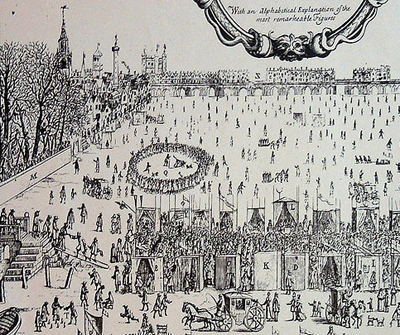
By the late 1700s and early 1800s, the gardens, one of a number of pleasure gardens in London, had reached the height of their popularity with reportedly more than 60,000 people said to have  attending a fancy dress party held one night in the late 1700s.

Those who attended events in the gardens included royalty as well as the likes of Samuel Johnson and James Boswell (see Thomas Rowlandson’s image above, Vauxhall Gardens, showing the likes of Johnson and Boswell, along with Georgina, Duchess of Devonshire, and the future King George IV, at the gardens in about 1779) as well as, much later, Charles Dickens (by the time Dickens visited, however, the heyday of the gardens was already well over).

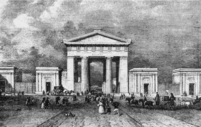
The gardens closed in 1859 due apparently to declining popularity and were eventually replaced with housing. After being badly bombed in World War II, however, the site once again returned to being a garden, known as Spring Gardens. The gardens (pictured) still occupy the site not far from Vauxhall tube station – part of them is used by the Vauxhall City Farm as paddocks for horses and livestock and they also contain a multi-use games court.

For an authoritative and comprehensive work on the Vauxhall Gardens, try David Coke and Dr Alan Borg’s Vauxhall Gardens: A History. There’s also much more information on David Coke’s website here. There’s also a detailed history here.

David Coke is curating an exhibition at The Foundling Museum, The Triumph of Pleasure, which looks at the way in which the gardens and the establishment of the Foundling Hospital in 1739 “changed the face of British art forever”. Runs from 11th May to 9th September. For more, see www.foundlingmuseum.org.uk.

PICTURES: Wikipedia and David Adams
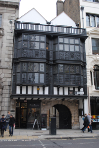
Lost London: Gates Special – The Stone Gate, London Bridge

And so we come to the last entry in our special series on Lost London looking at some of London’s gates – this time the only gate located on the south side of the Thames.

Located at the south end of London Bridge, this gate guarded the bridge entry in medieval times. When the first gate was built here remains something of a mystery but it is known that the first stone bridge, built in the late 1100s under the direction of priest Peter de Colechurch (it opened in 1209), certainly included a gatehouse known as the Stone Gateway (referred to by some as Bridge Gate) at the southern end.

The practice of parboiling the heads of traitors and the dipping them in tar before putting them on pikes above the gate apparently dates from 1305 when Scottish rebel William Wallace’s head was displayed there. The practice apparently continued until 1678 when goldsmith William Stayley’s head was the last to be displayed there.

As we mentioned in our earlier post on London Bridge, famous heads to adorn the gateway over the years included Peasant’s Revolt leader Wat Tyler in 1381, rebel Jack Cade in 1450, the former chancellor Sir Thomas More and Bishop John Fisher in 1535, Thomas Cromwell in 1540 and Guy Fawkes in 1606.

Pictured above is an enlarged detail of a 1616 print showing London Bridge by Claes Van Visscher – the heads are clearly visible on top. One German visitor famously counted 30 heads on top when he visited in 1598.

The gate (and it should be mentioned there was also another gate on the bridge with a drawbridge which was replaced by Nonsuch House in 1577) was presumably removed sometime after 1756 when an Act of Parliament authorised the removal of shops and houses on the bridge.

Of course, there are many other gates in London – some of them smaller gates in the city walls – which have been lost to time. We’ll be looking at some more of these in future posts…

PICTURE: Wikipedia

Lost London: Gates Special – Newgate

Better known now as the name for the infamous former prison which whom its history is intertwined, Newgate was originally one of the seven principal gates of London and, like five others, originally dates back to Roman times.

The gate, which apparently took the name ‘new’ thanks to a rebuild in the early medieval era, possibly in the reign of King Henry I or King Stephen, was located close to where the street known as Newgate meets the Old Bailey (see picture – there’s a blue plaque marking the spot on Newgate).

It was used as a prison from the 12th century for housing debtors and felons  – in the 13th century King Henry III is recorded as having issued orders for the prison’s repair (You can see our earlier entry on the prison here.)

The gate’s prison function – this was really no more than a few ‘cells’ – was substantially added to in the 1420s when, apparently as required under the terms of former Mayor Richard Whittington’s will, the gate was rebuilt and a new prison building was constructed to the south on what is now the site of the Old Bailey (home of the Central Criminal Court).

The gate was eventually demolished in the mid 18th century apparently due to urban planning issues. The prison, meanwhile, continued to be used until 1902 and was finally pulled down two years later.

Lost London: Gates Special – Moorgate

Originally a postern (small or secondary) gate built by the Romans, Moorgate came into its own as a larger gate in the 15th century and survived for more than 300 years before it was demolished in 1761.

The name comes from the area in which it stands – Moorfields, one of the last open pieces of space within the City of London – stood just to the north of the gate. It was originally a sparsely populated marshy expanse – so much so that when the gate was first built, the area around it was often flooded and some local residents used boats as a means of transport – but was later drained. Many people were evacuated here during the Great Fire of London in 1666 and some apparently then settled in the area which later also gained a reputation as a hiding place for highwaymen like Jack Sheppard – we’ll take a closer look at Moorfields in a later post.

The gate known as Moorgate, meanwhile, was first rebuilt as a full sized gate with towers in 1415 on the orders of then Mayor Thomas Falconer to provide access to the fields without. It was enlarged several times in medieval years before being damaged in the Great Fire. It was replaced with a ceremonial stone gate in 1672 to provide access to the now well-drained fields before being demolished in 1761 (some of the stone was apparently later used to support the newly widened central arch of London Bridge).

The gate’s name now lives on in the street known as Moorgate (originally formally known as Moorgate Street after it was first constructed in 1846) – worth noting is that the Romantic poet John Keats was born in the street. The area around the street also is also known by the name Moorgate and is home to some of the City’s key financial institutions.

There’s a plaque near where the site of Moorgate once stood at the corner of Moorgate and London Wall.

PICTURE: Moorgate in its final, ornate form. Taken from a London Wall Walk plaque.

Lost London: Gates Special – Cripplegate

Originally the northern gate of the Roman fort constructed in about 120 AD, Cripplegate was rebuilt several times during the medieval period before finally being demolished in 1760 as part of road widening measures.

The origins of the gate’s name are shrouded by the mists of time but it has been suggested that it was named for the beggars or cripples that once begged there or that it could come from an Anglo-Saxon word crepel which means a covered walkway.

The name may even be associated with an event which took place there in 1100 when, fearful of marauding Danes, Bishop Alwyn ordered the body of Edmund the Martyr, a sainted former Anglo-Saxon king, to be tranferred from its usual home in Bury St Edmunds to St Gregory’s Church near St Paul’s in London so that it could be kept safe. It was said that when the body passed through the gate, many of the cripples there were miraculously healed.

The gate (pictured here in an 18th century etching as it would have looked in 1663 in an image taken from a London Wall Walk plaque), which gave access in medieval times to what was then the village of Islington, was associated with the Brewer’s Company and was used for some time as a prison.

It was defensive works, known as a barbican, built on the northern side of the gate in the Middle Ages which are apparently responsible for the post World War II adoption of the name Barbican for that area of London which once stood outside the gate’s northern facade (the gates stood at what is now the intersection of Wood Street and St Alphage Garden).

The gate’s name now adorns the street known as Cripplegate as well as the name of the church St Giles Cripplegate, which originally stood outside the city walls. It is also the name of one of the 25 wards of the City of London. The original site of the gate is marked with a blue plaque.