Lost London – Baynard’s Castle (part 1)…

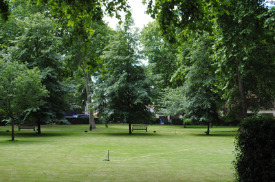
Baynard’s Castle actually refers to two buildings – a Norman fortification demolished in the early 13th century and a later medieval palace located to the east of the original structure. This week we’re looking at the first of those buildings – the Norman fortification.

Castle-BaynardThe first Baynard’s Castle was built in the late 11th century by Ralph Baynard (Baignard) and is believed to have replaced an earlier fortification at the site at the junction of the Thames and the Fleet rivers (the river now emerges into the Thames under Blackfriars Bridge).

Baynard (his name may be the origin of the name for Bayswater – Baynard’s Watering place – see our earlier post here), was the sheriff of Essex and a supporter of William the Conqueror.

The castle – which is said to have featured walls and parapets and which is generally said to have been on the waterfront (although some have said it was located inland) – remained in Baynard’s family until the reign of King Henry I when in 1111, his grandson William Baynard apparently forfeited his lands for supporting Henry’s eldest brother and would-be king, Robert Curthose.

It was later passed to the King’s steward Robert Fitz Richard, son of the Earl of Clare, and is known to have been inherited by his grandson, Robert Fitzwalter.

Fitzwalter, however, was a key opponent of King John and as early as 1212 he was in hot water for his part in a conspiracy against the king, although he stated it was because the king tried to seduce his daughter, Matilda the Fair. Either way, he escaped trial by heading to France and John seized the opportunity to raze the castle which he did on 14th January, 1213.

Fitzwalter was later forgiven under an amnesty and went on to play a leading role among the baronial opposition to Kong John – he was among 25 barons charged with enforcing the promises of the Magna Carta of 1215.

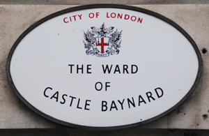
The name Baynard’s Castle is remembered in the London ward of Castle Baynard (pictured) which covers the area in which it once stood.

What’s in a name?…Bayswater

The origins of the name of this inner west London location on the northern side of Hyde Park and Kensington Gardens go back to at least the 14th century when it was recorded as Bayard’s or perhaps Baynard’s watering place.

Bayard was the word for a bay-coloured horse but it is thought that instead the name here comes from a local landowner – it’s been suggested he may be the same Baynard whose name is was remembered in the long gone Norman fortification Baynard’s Castle in the City.

The name probably referred to a site where people on their way out of or headed to London stopped for a rest and some water; the water aspect may relate to springs or to the Westbourne Stream which ran through the area.

It’s now known for its culturally diverse population and high concentration of hotels. It’s also known for Georgian terraces – many of which have been converted into flats, mansion blocks and garden squares.

Notable residents have included Peter Pan author JM Barrie and former PM’s Tony Blair and Winston Churchill while landmarks include Whiteleys, a department store which first opened in the mid 19th century (and was later rebuilt after burning down).

This Week in London – Celebrating the Year of the Bus; the British Library looks at WWI; medieval jousting and The Duke of Wellington; and, Blue Plaque nominations resumed…

BusesAlmost 50 buses, from a horse-drawn model of the 1820s to the New Routemasters of today, will come to Regent Street on Sunday in celebration of the Year of the Bus. The ‘Regent Street Bus Cavalcade’ – which will stretch from Piccadilly Circus to Oxford Circus and will see the iconic West End street closed to traffic – will also feature a variety of free family events including Lego workshops (there will be a bus shelter and bus stop made entirely out of Lego outside Hamley’s toy shop), children’s theatre performances, a pop-up London Transport canteen and the chance to have a personal message recorded by the voice of London’s buses, Emma Hignett. There will also be an exhibition – Battle Bus – which provides information about the B-type bus (a newly restored version of which will be on display) which was used during World War I to carry soldiers to the frontline as well as ambulances and mobile pigeon lofts while jewellery company Tatty Devine will feature a special range of bus-inspired jewellery and hold jewellery-making workshops on board a London bus. The cavalcade, supported by the Regent Street Association and The Crown Estate, is part of Transport for London’s celebrations marking the Year of the Bus, organised in partnership with the London Transport Museum and the capital’s bus operators. The free event runs from 11.30am to 6pm. For more information, see www.tfl.gov.uk/yearofthebus and www.ltmuseum.co.uk.

A new exhibition of materials showing how people coped at home and on the front during World War I opens at the British Library in King’s Cross today as part of efforts to mark the war’s centenary. Enduring War: Grief, Grit and Humour features personal objects such as letters, a handkerchief bearing the lyrics of It’s A Long, Long Way to Tipperary, Christmas cards, school essays about airship raids over London sit and recruitment posters, humorous magazines and even a knitting pattern for balaclavas. Highlights include a letter in which Sir Arthur Conan Doyle expresses his concern over his son serving at the front, manuscripts by war poets such as Rupert Brooke as well as Wilfred Owen’s manuscript for Anthem for Doomed Youth, Vaughan Williams’ A Pastoral Symphony and Laurence Binyon’s For the Fallen. A specially commissioned video and ‘soundscape’, Writing Home, features personal messages contained on postcards written to and from the front. A range of events accompanies the free exhibition. Runs until 12th October. For more on the exhibition, see www.bl.uk.

Armoured knights on horseback can be seen jousting at Eltham Palace in south London this weekend. The former childhood home of King Henry VIII will host a Grand Medieval Joust which will also include displays of foot combat, the antics of a court jester, medieval music performances and a series of children’s events including a knight’s school. Runs from 10am to 5pm on both Saturday and Sunday. Admission charge applies. For more, see www.english-heritage.org.uk/events. Meanwhile, the Battle of Waterloo is being remembered at the Duke of Wellington’s home of Apsley House near Hyde Park Corner. Visitors will come face-to-face with Wellington’s troops and their wives, having the chance to take a look inside a soldier’s knapsack, see the equipment he used and the drills he performed as well as see the Battle of Waterloo recreated in vegetables. The Waterloo Festival – this year marks 200 years since Napoleon’s abdication and exile to Elba – runs from 11am to 5pm on Saturday and Sunday. Admission charge applies. For more, see www.english-heritage.org.uk/apsley/.

Nominations have reopened for English Heritage’s Blue Plaques scheme in London. In 2012 nominations were temporarily suspended while new funding for the scheme was found and thanks to one individual’s donation and the creation of a new Blue Plaques Club to support the scheme on an ongoing basis, they have now reopened. There are 880 official Blue Plaques on London’s streets – remembering everyone from Florence Nightingale to Fred Perry and Charles Darwin. For more and details on nominations, see www.english-heritage.org.uk/discover/blue-plaques/.

Send all items of interest for inclusion to exploringlondon@gmail.com.

Lost London – The Steelyard…

The Thames-side property known as the Steelyard – the phrase comes from the Dutch-German word Stahlhof and relates either to a steel beam used for weighing goods or a courtyard where the goods were sold – was the main trading base of the Hanseatic League in London from the 13th century onward.

Located near where Walbrook flows out of the Thames on the north bank (the site is now at least partly covered by Cannon Street Station), the walled compound – which at some point housed as many as 400 people – was in some senses a mini city within a city complete with a hall, warehouses, a weighing house and counting houses as well as residences and a chapel.

While the community – which represented an alliance of towns and cities in northern Europe – was mentioned as far back as the late 1200s, it wasn’t until 1303 that King Edward I formerly confirmed the tax and customs concessions of the merchants (at some point, in return for privileges they were given, the group was charged with keeping up the maintenance of Bishopsgate).

The power of the trading post had grown substantially by the 15th century and the concessions the group had been granted meant there was inevitably considerable friction with English merchants. There was also some official friction and one example of it was when the Steelyard was closed temporarily in the 15th century when the Hanse cities were at war with England.

In 1598 Queen Elizabeth I took away the Steelyard’s trading privileges (after which the compound was apparently looted). It was subsequently allowed to reopen by King James I but never regained the prominence it had previously had.

Much of the compound was destroyed in the Great Fire of London but nonetheless, the Steelyard was rebuilt and continued to provide links between German cities and the English until the mid 1800s when the land was sold off and, in 1866, Cannon Street Station built on the site.

A couple of surviving objects from the Steelyard include a series of at least eight portraits of Hanse merchants painted by Hans Holbein the Younger and a stone model of the Hanseatic Arms which were placed over the gate into the compound can be seen at the Museum of London.

A Moment in London’s History – The Battle of Barnet helps to secure the throne for King Edward IV (again)…

It was exactly 543 years ago today that the Battle of Barnet – one of the key battles of the Wars of the Roses – was fought near what was then the small town of Barnet but is now an area on Greater London’s outer northern fringe.

Hadley-HighstoneKing Edward IV, returning from exile in Burgundy after he was ousted by the Lancastrians, led an estimated 10,000 Yorkists in an engagement with some 15,000 Lancastrians (who backed King Henry VI) under the command of Richard Neville, 16th Earl of Warwick and known as the Kingmaker, who had previously supported the Yorkists (and before that the Lancastrians).

The forces met on 14th April, 1471, at around dawn but thick fog sewed confusion in the Lancastrian ranks with allies attacking each other and the army eventually fell apart amid cries of treachery. Warwick was killed in the battle as he attempted to flee.

The exact site of the battle remains something of an unknown although it is thought to span the community of Monken Hadley just to the north of Barnet itself (that is the area marked on the official English Heritage Register of Historic Battlefields).

A stone monument to the battle, the Hadley Highstone, was erected in the 18th century and in the 1800s was moved to its current location at the junction of Kitts End Road with the Great North Road in Monken Hadley and was originally thought to have marked the spot on which Warwick died. The Battlefields Trust is currently developing a project to pin down the location further.

The battle was important because, along with the following Battle of Tewkesbury during which the Lancastrian heir Edward was killed (and the murder of King Henry VI shortly after), it secured the throne for King Edward IV for the next 14 years.

PICTURE: Nigel Cox/Wikipedia

London Pub Signs – The Minories…

The-MinoriesLocated close to Tower Hill in the eastern part of the City, this pub – and indeed the street in which it sits (at number 64-73) – takes its name from a former nunnery that was once located here.

Known as the Minoresses, the nuns – who belonged to the Order of St Clare (also known as the Poor Clares) – lived in a nunnery here. The institution was founded by in 1293 by Edmund, the brother to King Edward I (reigned 1272-1307), and the earl of Lancaster, Leicester, and Derby, to house nuns who had been brought to England from Spain by the earl’s wife, Blanche of Artois, the widow of King Henry I of Navarre.

As with the case of the Black Friars, the name came to be used to refer to the district in which the now long-gone nunnery once stood (it was dissolved in the Great Dissolution and later used as a residence by the likes of Henry, Duke of Suffolk and father of Lady Jane Grey) and lives on in the name of the street and the pub.

The pub, which has undergone a paint job since our picture was taken, is located under a railway bridge (and may have once been part of the former Minories Railway Station which closed in 1873. For more, see www.minories-london.co.uk.

10 significant sites from Georgian London – 4. St Martin-in-the-Fields…

This iconic church on the edge of Trafalgar Square, known for its musical associations, is another of the works of architect James Gibbs and, as with St Mary le Strand, the current building was constructed in the first half of the 18th century to replace an earlier building.

St-Martin-in-the-fieldsThe first references to a church on the site of the present building date back to the 13th century when, constructed upon a Roman burial site, it was apparently used by monks from Westminster. It was replaced by King Henry VIII around 1542 and enlarged in 1602 before finally being demolished in 1721.

Gibbs’ apparently first suggested the design feature a round nave with a dome over the top but the proposal was rejected as too expensive and a simpler, rectangle-shaped church was subsequently agreed upon and eventually completed in 1726. Part of the design inspiration comes from Sir Christopher Wren, although Gibbs’ integration of the tower into the church was a departure from Wren’s designs (the church spire rises 192 foot into the air).

Among the features of the interior are ceiling panels in the nave which feature cherubs and shells and are the work of ceiling experts Giuseppe Artari and Giovanni Bagutti. Other items of interest include Chaim Stephenson‘s sculpture, Victims of Injustice and Violence, remembering all victims during apartheid in South Africa (it was dedicated by Desmond Tutu in 1994), a statue of St Martin and the Beggar by James Butler, and, on the porch, Mike Chapman‘s sculpture marking the millennium, Christ Child. Paintings include one of James Gibbs himself by Andrea Soldi and dating from 1800.

Among those buried in the church are furniture-maker Thomas Chippendale, sculptor Louis-François Roubiliac and notorious robber Jack Sheppard (he’s buried in the churchyard). The crypt also contains a life-sized marble statue of Henry Croft, London’s first pearly king, which was moved there from St Pancras Cemetery in 2002.

As well as being the location of the first religious broadcast, its musical heritage includes performances by Handel and Mozart and being the location of the first performance of its namesake chamber orchestra, the Academy of St Martin in the Fields.

Since the early 20th century, the church has been noted for its work with the homeless (thanks in particular to the work of Vicar Dick Sheppard). Meanwhile, its connections with music – which date back to its rebuilding – continue in the concerts held in the crypt cafe. The crypt also hosts art exhibitions.

The church underwent a £36 million renewal project in the Noughties. Additions included the new east window by Shirazeh Houshiary.

WHERE: St Martin-in-the-Fields on the north-east corner of Trafalgar Square (nearest tube stations are Charing Cross, Leicester Square and Embankment); WHEN: Open weekdays and weekends – times vary, see website for details; COST: free; WEBSITE: www.stmartin-in-the-fields.org.

Lost London – Strand Cross…

Many of us are familiar with the story of Charing Cross and why it was so named (see our earlier post here), but maybe not so much with another of London’s ‘crosses’ – Strand Cross.

Earlier this week we posted a story on St Mary le Strand – one of the details we didn’t mention (deliberately, it has to be said) was that the current church now stands on the site once occupied by the cross.

Believed to have dated from at least Norman times, Strand Cross – which stood just outside the city gates – may have begun life as a market cross and it’s recorded that in the 13th century, justices held court in front of it.

By the early 14th century has been rather elaborately rebuilt in a fashion not unlike that of the Eleanor Crosses.

In the late 17th century, the cross – which had apparently already lost its top – was replaced by a windmill to pump water – apparently there was a well or spring nearby – and this in turn was later replaced by one of London’s most famous maypoles (we’ll be looking at maypoles in more detail in a later post).

Famous Londoners – Wynkyn de Worde…

Known as the “Father of Fleet Street”, Wynkyn de Worde was key figure in the early use of the printing press in England.

Wynkyn_de_WordeBorn on the continent (candidates include Wœrth in Alsace in north-east France and Wœrden in The Netherlands), Wynkyn – whose name comes in various spellings, although it is said to have originally been Jan van Wynkyn – is believed to have become apprenticed to a printer in Cologne before meeting with famed pioneering English printer William Caxton in the early 1470s.

He apparently accompanied Caxton from Cologne to Bruges and then back to London in the late 1470s or early 1480s where he started working with Caxton at his premises in Westminster. During this period he is said to have lived with his English wife Elizabeth in a premises located with the sanctuary of Westminster Abbey (they are known to have attended St Margaret’s Church and even rented a pew there until Elizabeth’s death in 1498, after which Wynkyn is believed to have remarried.)

After Caxton’s death in 1492, Wynkyn took over his printing business and, around 1500, he relocated his office from Caxton’s Westminster premises to the “sign of the Sun” in Fleet Street near Shoe Lane – in fact, he is credited as being the first printer to locate in the street which becomes famously associated with publishing. There’s a plaque (pictured below), on the wall of the hall of the Worshipful Company of Stationers, located off Ave Maria Lane near St Paul’s Cathedral, commemorating the move (although Shoe Lane is located some distance away). Wynkyn later also ran a shop in St Paul’s Churchyard.

Wynkyn-de-Worde2While Wynkyn, like Caxton before him, relied on the patronage of the rich and famous (Margaret Beaufort, mother of King Henry VII among them), he also printed relatively inexpensive books in a bid to capture a wider market. In all he published more than 400 different books in at least 750 editions ranging from religious texts and poetry to fictional romantic works, educational textbooks and books aimed at children. He is noted for his use of woodcuts illustrations while his other claims to fame include being the first English printer to use italic type and the first to print music from moveable type.

De Worde died around 1534 but his legacy lives on through the mass media publishing of today (albeit not longer from Fleet Street). There is a Wynkyn de Worde Society based in Suffolk which is aimed at furthering the printing industry.

PICTURE: Wikipedia

What’s in a name?…Fetter Lane…

The name of this central London thoroughfare – which runs from Fleet Street to a dead-end just shy of Holborn, with New Fetter Lane forking off to continue the journey to Holborn Circus – has nothing to do with fetters, chains or prisoners.

Fetter-LaneRather its name – a form of which apparently first starts to appear in the 14th century – is believed to be a derivation of one of a number of possible Anglo-French words – though which one is anyone’s guess.

The options include the word fewtor, which apparently means an idle person or a loafer, faitor, a word which means an imposter or deceiver (both it and fewtor may refer to a colony of beggars that lived here) feuterer, a word which describes a ‘keeper of dogs’, or even feutrier, another term for felt-makers.

Buildings of note in Fetter Lane include the former Public Records Office (now the Maughan Library, part of King’s College, it has a front on Chancery Lane but backs onto the lane), and the former Inns of Chancery, Clifford’s Inn and Barnard’s Inn (current home of Gresham College).

It was also in Fetter Lane, at number 33, that the Moravians, a Protestant denomination of Christianity, established the Fetter Lane Society in 1738 (members included John Wesley). The original chapel was destroyed in bombing in World War II ( a plaque now marks the building where it was)

And there’s a statue of MP, journalist and former Lord Mayor, John Wilkes, at the intersection with New Fetter Lane (pictured).

Where’s London’s oldest…public library?

While the designation of London’s oldest public library depends on your definition, for the purposes of this article we’re awarding the title to the Guildhall Library.

Its origins go back to about 1425 when town clerk John Carpenter and John Coventry founded a library – believed to initially consist of theological books for students, according to the terms of the will of former Lord Mayor, Richard (Dick) Whittington (for more on him, see our previous post here).

Guildhall2Housed in Guildhall (pictured above), this library apparently came to an end in the mid-1500s when Edward Seymour, the Duke of Somerset and Lord Protector for the young King Edward VI, apparently had the entire collection loaded onto carts and taken to Somerset House. They were not returned and only one of the library’s original texts, a 13th century metrical Latin version of the Bible, is in the library today.

Some 300 years passed until the library was re-established by the City of London Corporation. Reopened in  1828, it was initially reserved for members of the Corporation but the membership was soon expanded to include”literary men”.

By the 1870s, when the collection included some 60,000 books related to London, the library moved into a new purpose-built building, located to the east of Guildhall. Designed by City architect Horace Jones, it opened to the public in 1873.

The library lost some 25,000 books during World War II when some of the library’s storerooms were destroyed and after the war, it was decided to build a new library. It opened in 1974 in the west wing of the Guildhall where it remains (entered via Aldermanbury).

Today, the 200,000 item collection includes books, pamphlets, periodicals including the complete London Gazette from 1665 to the present, trade directories and poll books as well as the archive collections such as those of the livery companies, the Stock Exchange and St Paul’s Cathedral and special collections related to the likes of Samuel Pepys, Sir Thomas More, and the Charles Lamb Society.

The library also holds an ongoing series of exhibitions.

Where: Guildhall Library, Aldermanbury; WHEN: 9.30am to 5pm, Monday to Saturday; COST: Entry is free and no membership of registration is required but ID may be required to access rarer books; WEBSITE: www.cityoflondon.gov.uk/things-to-do/visiting-the-city/archives-and-city-history/guildhall-library/Pages/default.aspx.

Where’s London’s oldest…museum?

Power-House

London’s oldest museum is not the British Museum or any of the Kensington museums but is actually contained within one of the city’s iconic structures.

Located within the Tower of London, the Royal Armouries Museum takes the prize of being not only the city’s oldest museum but oldest museum in the whole of Britain.

It’s origins go back to medieval times when the tower housed the main royal arsenal and was a working armoury and, by the time of the Restoration, there was a permanent public display in the White Tower with the star attractions being the Spanish Armoury, a collection of weapons and torture instruments claimed to have been taken from the Spanish Armada of 1588, and the Line of Kings (see our earlier post on this here).

Other displays – including one focused on artillery and another on horses – were subsequently added in various buildings within the tower precincts including in the Grand Storehouse which, located to the north of the White Tower, destroyed by fire in 1841. Over the ensuing years, the displays were moved back into the White Tower.

As well as the revamped Line of Kings and the Power House exhibition looking at the people, institutions and history of the Tower, the current display includes a dragon made of more than 2,600 items of weaponry, following a long-standing tradition in the museum of creating displays out of masses of weapons.

As well as continuing its presence at the Tower of London, the museum is now also housed at Fort Nelson at Portsmouth – this opened in 1995 when it became home to the museum’s artillery collection – and in Leeds, which opened in 1996. There’s also some weapons on display in Louisville, Kentucky, in the US, under a  cooperative agreement with the Frazier International History Museum.

PICTURE: ‘Keeper’, the Dragon trophy – part of the Power House display in the Royal  Armouries Museum at the Tower of London. HRP newsteam.

WHERE: Tower of London (nearest Tube station Tower Hill); WHEN: 9am to 5.30pm, Tuesday to Saturday, 10am to 5.30pm Sunday to Monday; COST: £21.45 adults; £10.75 children under 15; £18.15 concessions; £57.20 for a family; WEBSITE: www.hrp.org.uk/toweroflondon/.  

Lost London – The Pillories…

Once a visible sign of London’s legal system, the city had several pillories which were used to degrade and humiliate those offenders put within them.

Titus-OatesOriginating in medieval times, the pillories were wooden contraptions in which a standing person’s head and hands were held in place and exposed to the ridicule of the crowd (not to mention their rotten foodstuffs and other less savoury things). They were a similar form of punishment to the stocks and were designed to humiliate those put within them.

They were used to punish a broad range of offenders including everyone from con-men and forgers to traders who didn’t play fair with their customers, people publishing unlicensed literature, and homosexuals.

Some people were pilloried repeatedly and additional punishments could be handed out to some put in the pillory – such as the nailing of the offender’s ears to the structure. There was cases of enraged mobs injuring the person locked in the pillory so badly that they died and the journey to the pillory – a formal parade of the malefactor before the people – was another chance for people to shout abuse and throw things at the offender.

As well as in Charing Cross where the pillory was located just to the south of Trafalgar Square, pillories were found at locations in Cheapside, Cornhill and Old Bailey in the City as well as Old Palace Yard and Tyburn in Westminster.

Among the most famous occupants of London’s pillories was the writer Daniel Defoe. The author of Robinson Crusoe and Moll Flanders, he was placed here on 31st July,1703, due to his publication of pamphlets criticising the church. It didn’t prove the harshest of punishments, however – Defoe was greeted with flowers, not stones, by a crowd rather sympathetic to his cause.

Others to suffer the punishment of the pillory included Titus Oates, who fabricated a plot to kill King Charles II, and puritan William Prynne, who lost both his ears when pilloried for libelling Queen Henrietta Maria  (although they were apparently sewed back on before he lost them again for a subsequent offence).

The punishment was formally abolished in 1837 – the last time it was used was in 1830.

PICTURE: Wikipedia. Image is from Robert Chambers’ Book of Days, 1st edition.

What’s in a name?…Gracechurch Street…

This central London thoroughfare runs through the heart of the City of London and has been a main thoroughfare since Roman times.

Gracechurch-StreetStretching from Eastcheap (near the Monument) to Leadenhall Street, the street runs over the site of what was Roman London’s forum and basilica (see our earlier post on the Roman buildings here).

The name, meanwhile, comes from the former medieval church of St Benet Gracechurch which was once located on the corner of Gracechurch and Fenchurch Streets.

The church, which was destroyed in the Great Fire of 1666 but rebuilt by Sir Christopher Wren before finally being demolished in 1876, was named for St Benedict (St Benet is a short form) while Gracechurch – which was used after the Great Fire – was a corruption of Grasschurch, a reference to it being located near a hay market (in fact, the church was also known as St Benet Grass). The street was also known as Gracious Street.

Landmarks along Gracechurch Street including the Leadenhall Market (see our earlier post here) and a 30s-inspired modern building of note which stands at number 20.

PICTURE: Looking down Gracechurch Street toward the Monument.

For more on London’s Wren churches, see John Christopher’s Wren’s City of London Churches.

Lost London – St Paul’s Cross…

Paul's-Cross-Memorial

Located in the north-east corner of the churchyard of St Paul’s Cathedral, St Paul’s Cross – also known simply as Paul’s Cross – was a large free-standing cross which served as an open-air pulpit for at least 500 years.

The history of the Cross goes back to at least the 12th century and it long served as a public gathering place for Londoners to hear sermons or matters of public importance. King Henry III met Londoners here in 1259 so they could swear their allegiance, people like 15th century chaplain Richard Walker appeared here to plead guilty for crimes against the church (in his case to charges of sorcery) and it was here that William Tyndale’s testaments were burnt in the 16th century.

Pauls-Cross2Conversely, it was also from here that the English Reformation was preached (there’s a painting in the Houses of Parliament of King Edward VI listening to a sermon preached from the Cross by reformist Bishop Latimer). It has been said that if all the sermons preached here had been collected, they would effectively make a history of the Church of England.

While it was a simpler structure in its earlier years, in the late 15th century, the then Bishop of London, Thomas Kempe, ordered the construction of a ‘preaching station’ on the site. It was an elevated small wooden structure with a lead roof topped by a cross under which a preacher and a couple of others could stand.

The cross and pulpit were destroyed during the English Civil War in 1643.

These days there’s a plaque marking the original site of the cross (above). In 1910, the St Paul’s Cross Memorial – a column topped with a gilt statue of St Paul designed by Sir Reginald Blomfield (pictured top), was installed nearby (as ordered by the will of HC Richards, according to a plaque on the site) and remains there today.

The Virtual Pauls Cross website, led by Professor John N Wall of North Carolina State University in the US, reconstructs what the site would have looked like when John Donne gave his Gunpowder Day sermon on 5th November, 1622.

Lost London – St Dunstan in the East…

St-Dunstan-in-the-East

The ruins of this medieval church can still be found in the eastern end of the City of London and now play host to a rather delightful little park.

Originally built around 1,100 in the Gothic style, the church – which stands between St Dunstan’s Hill and Idol Lane (off Great Tower Street) was enlarged and repaired in ensuing centuries before suffering severe damage in the Great Fire of London in 1666. Not enough to destroy the church, however, and it was repaired in the late 1660s with a new steeple and tower designed by Sir Christopher Wren to fit with the existing structure, was added in the late 1690s. Inside were carvings by Grinling Gibbons.

St-Dunstan-in-the-East-smallBut by the early 19th century, however, the weight of the roof had pushed the walls dramatically out of line and, after an unsuccessful attempt to repair the church, it was decided to demolish it (with the exception of Wren’s tower) and rebuild.

Built in the Perpendicular style to the designs of David Laing, the new church reopened in 1821.

The church lasted for more than 100 years before it was again severely damaged, this time during the Blitz of 1941. Wren’s spire and tower thankfully remained but other than that it was a shell with only the north and south walls remaining.

The Anglican Church decided not to rebuild – the parish was incorporated into that of All Hallows by the Tower – and the City of London Corporation opted to turn the (now) Grade I-Iisted remains into a public park. It was opened in 1971 by the then Lord Mayor of London, Sir Peter Studd.

It remains there today, with beautiful climbing foliage – including many exotic plants – and a fountain in the nave. The tower, meanwhile, is used by a complementary medical centre.

A great place to pass a lunch hour!

What’s in a name?…St Mary Axe

There’s several stories behind the rather odd name given to this narrow street which runs between Houndsditch and Leadenhall Street in the City of London – now famous for the gherkin-shaped skyscraper located within it.

St-Mary-AxeIt’s generally agreed that street’s name comes – at least partly – from a former church which it has been suggested once stood where the building known as Fitzwilliam House now stands.

Known as the Church of St Mary Axe (although its full name was apparently the somewhat longer Church of St Mary, St Ursula and her 11,000 Virgins), the medieval building was apparently demolished in the 1560s and the parish united with that of St Andrew Undershaft (this church still sits on the corner of St Mary Axe and Leadenhall Street).

The reasons for the church to be so named remain a matter of speculation. The most interesting version (and the one that would explain the church’s longer name) has it that the name was given due to an axe that was once on display in the church.

The axe had apparently come from Europe where legend says it was one of three axes used by the Huns (some say the three included Atilla himself) to slaughter 11,000 handmaidens who had been travelling in Europe with St Ursula. St Ursula herself was fatally shot with arrows by the Huns’ leader.

How and why the axe came to be on display in this particular church remains something of a mystery but so well did the church become identified with the gruesome relic that it became known as the church of St Mary Axe.

Another version we’ve come across states that the church took on the name because its patrons were the the Skinners’ Company who used such axes. Yet another suggests that the street was named after the church of St Mary and that of a nearby tavern which operated under a sign bearing the image of an axe (but it’s possible the tavern had such a sign because of its proximity to the church in the first place).

These days, as well as being the location of St Andrew Undershaft (now part of the parish of St Helen’s Bishopsgate) and the building known as the Gherkin (it’s official name is 30 St Mary Axe), St Mary Axe is also the place where, on 10th April, 1992, an IRA bomb exploded outside the Baltic Exchange, killing three people.

PICTURE: The Gherkin with St Andrew Undershaft in the foreground.

10 (more) curious London memorials…3. William Wallace Memorial…

William-Wallace-memorialHe was captured in Scotland but it was actually at Smithfield in London that the Scottish leader, Sir William Wallace, was put to death on 23rd August, 1305.

Erected in 1956 by “Scots and friends at home and abroad”, a plaque located on the wall of St Bartholomew’s Hospital overlooking the former execution ground commemorates the “Scottish patriot” Wallace, saying that from the year 1296 “fought dauntlessly in defence of his country’s liberty and independence in the face of fearful odds and great hardship”. It goes on to note that he was “eventually betrayed”, captured and executed “near this spot”.

Elsewhere the memorial reads: “His example, heroism and devotion inspired those who came after him to win victory from defeat and his memory remains for all time a source of pride, honour and inspiration to his countrymen”.

Having co-led the Scottish to victory against the army of King Edward I at the Battle of Stirling Bridge in 1297, Wallace was later knighted for his efforts and subsequently served as a Guardian of the Kingdom of Scotland.

Following his defeat at English hands in the Battle of Falkirk in 1298, he escaped and continued to evade capture until he was apprehended near Glasgow in August 1305. Brought to London where he was put on trial in Westminster Hall. Summarily found guilty of treason, he was stripped naked and dragged to Smithfield and it was there that he suffered the horrible death of being hung, drawn and quartered.

And while the 1995 movie, Braveheart, had Wallace crying out “Freedom” as he died, his last words are actually not recorded. His tarred head was subsequently displayed on a pike atop London Bridge while his limbs were sent to towns including Stirling in Scotland.

What’s in a name?…Old Bailey…

Running from Ludgate Hill to Newgate Street in the western part of the City, there are a couple of explanations behind the thoroughfare known as the Old Bailey.

Old-BaileyOne suggests that the name is derived from Latin word ballium which referred to a wall built for defence and which, in this instance, referred to the old Roman wall which surrounded the City.

Another, according to Antony Badsey-Ellis’ book What’s in a Street Name?, is that the name could be a corrupt form of ‘Bail Hill’ – a place where a bailiff held court.

For centuries the street’s name has also been used for that of a court based there. Now formally known as the Central Criminal Court, the first court – or sessions house – was built here in 1539 on part of the site now occupied by the court.

Built next to the Old Bailey court house – and pre-dating it was Newgate Prison – but when this was demolished in 1902, the Old Bailey (which itself had been rebuilt in the 1670s having been destroyed in the Great Fire of London and then subsequently remodelled) was again rebuilt and, opening in 1907, now covers the site.

For an archive of the court’s proceedings, check out www.oldbaileyonline.orgFor more on the history of The Old Bailey, check out Theresa Murphy’s The Old Bailey: Eight Hundred Years of Crime, Cruelty and Corruption.

10 Historic London Garden Squares…10. Charterhouse Square…

Charterhouse-Square-GardensThe final in our series on historic garden squares in London (for this year, anyway), we’re taking a look at Charterhouse Square.

The five sided square, located just to the east of Smithfield, takes its name from a Carthusian monastery which was established in 1371 on what is now its north side. Prior to this, what is now the square had from 1348 served as a location for a plaque burial pit (a number of skeletons from the plaque pit have been unearthed as part of the Crossrail project – for our earlier story on this, follow this link).

The monastery was dissolved in 1537 after the monk’s refused to recognise King Henry VIII’s Act of Supremacy (some were later executed at Tyburn) and it was subsequently transformed into a manor house with Thomas Howard, the 4th Duke of Norfolk, among its residents over the years (in fact he was imprisoned there around 1570 for allegedly plotting to marry Mary, Queen of Scots – he was later executed by Queen Elizabeth I for treason).

Under the will of Thomas Sutton, an almshouse and school was subsequently established on the site – the almshouse remains there while the school, whose students had included Methodism founder John Wesley and writer William Makepeace Thackeray, moved out to Godalming in Surrey in 1872. As well as the almshouse (which is open for guided tours, check this site for details), some of the buildings are now occupied by medical related institutions.

In the 1600s, the square was also home to numerous other large residences among them Rutland House, which had been the residence of the Venetian ambassador. It lost its aristocratic inhabitants in the ensuing centuries but remained mainly residential up until the late 19th century when it gradually became taken over by businesses and other organisations. Interesting to note is that the east side of the square is still home to the residential unit complex known as Florin Court, better known as Whitehaven Mansions, the home of Hercule Poirot in the TV series which bears his name.

The area of the garden square itself was variously referred to as the Charterhouse Churchyard, the Charterhouse Yard and Charterhouse Close over the years and has gone through numerous incarnations with efforts to improve and formalise its look dating back to at least the 16th century. It was at least partly enclosed by the late 1600s and the fences replaced several times, notably in 1742 when an Act of Parliament was passed allowing residents to fine those who entered without authorisation. The enclosing fences have since been modified several more times.

One of the major changes to the shape of the square occurred in 1860 when the Metropolitan Railway was extended between Farringdon and Moorgate. It was at this time that the road surface which surrounds the central garden, which has a Grade II heritage listing, was laid down.

Today the gardens in the centre of the square remain under the management of the Charterhouse (and hence aren’t open to the general public except on tours) but even without a tour it’s still a quiet place to walk around the outside of, evoking a strong sense of years gone past.